FAA INFORMATION EFFECTIVE 14 MAY 2026
Location
| FAA Identifier: | HPY |
| Lat/Long: | 29-47-09.9000N 094-57-09.6000W
29-47.165000N 094-57.160000W
29.7860833,-94.9526667
(estimated) |
| Elevation: | 33.8 ft. / 10.3 m (surveyed) |
| Variation: | 03E (2010) |
| From city: | 3 miles N of BAYTOWN, TX |
| Time zone: | UTC -5 (UTC -6 during Standard Time) |
| Zip code: | 77521 |
Airport Operations
| Airport use: | Open to the public |
| Activation date: | 12/1958 |
| Control tower: | no |
| ARTCC: | HOUSTON CENTER |
| FSS: | MONTGOMERY COUNTY FLIGHT SERVICE STATION |
| NOTAMs facility: | CXO (NOTAM-D service available) |
| Attendance: | 0800-1700 |
| Wind indicator: | lighted |
| Segmented circle: | yes |
| Lights: | ACTVT REIL RWY 14 & 32; PAPI RWY 14 & 32; MIRL RWY 14/32 - CTAF. |
| Beacon: | white-green (lighted land airport)
Operates sunset to sunrise. |
Airport Communications
| CTAF/UNICOM: | 122.8 |
| HOUSTON APPROACH: | 134.45 |
| HOUSTON DEPARTURE: | 134.45 |
| BLTWY RNAV DP: | 134.45 |
| BLUBELL STAR: | 124.225 |
| BORRN RNAV DP: | 134.45 |
| CESAN STAR: | 121.3 |
| DREMR DP: | 134.45 |
| HOODO RNAV DP: | 134.45 |
| HUDZY STAR: | 120.05 |
| INDIE RNAV DP: | 134.45 |
| KARRR RNAV DP: | 134.45 |
| LURIC DP: | 134.45 |
| MMALT RNAV DP: | 134.45 |
| OHIIO STAR: | 120.05 |
| SNDAY RNAV STAR: | 124.225 |
| STRYA DP: | 134.45 |
| STYCK DP: | 134.45 |
| TKNIQ STAR: | 119.625 |
| TSHIRT STAR: | 119.175 |
| TSHRT STAR: | 119.175 |
| WAPPL STAR: | 120.05 |
| WATFO DP: | 134.45 |
| WYLSN RNAV DP: | 134.45 |
| WX AWOS-3PT at T41 (9 nm SW): | 120.275 (281-471-2206) |
| WX AWOS-3 at EFD (15 nm SW): | 135.575 (713-847-4430) |
| WX ASOS at HOU (19 nm SW): | PHONE 713-847-1462 |
Nearby radio navigation aids
| VOR radial/distance | | VOR name | | Freq | | Var |
|---|
| MHFr316/17.9 | | TRINITY VOR/DME | | 114.75 | | 07E |
| IAHr112/22.9 | | HUMBLE VORTAC | | 116.60 | | 05E |
| DASr208/29.0 | | DAISETTA VORTAC | | 116.90 | | 05E |
| VUHr346/31.3 | | SCHOLES VOR/DME | | 113.00 | | 06E |
Airport Services
| Fuel available: | 100LL JET-A+ |
| Parking: | hangars and tiedowns |
| Airframe service: | MAJOR |
| Powerplant service: | MAJOR |
Runway Information
Runway 14/32
| Dimensions: | 4334 x 60 ft. / 1321 x 18 m |
| Surface: | asphalt, in good condition |
| Weight bearing capacity: | |
| Runway edge lights: | medium intensity |
| RUNWAY 14 | | RUNWAY 32 |
| Latitude: | 29-47.449667N | | 29-46.880667N |
| Longitude: | 094-57.408333W | | 094-56.912150W |
| Elevation: | 33.8 ft. | | 27.4 ft. |
| Traffic pattern: | left | | left |
| Runway heading: | 140 magnetic, 143 true | | 320 magnetic, 323 true |
| Displaced threshold: | 786 ft. | | 721 ft. |
| Declared distances: | TORA:4088 TODA:4088 ASDA:4088 LDA:3320 | | TORA:4003 TODA:4003 ASDA:4003 LDA:3283 |
| Markings: | nonprecision, in fair condition | | nonprecision, in fair condition |
| Visual slope indicator: | 2-light PAPI on left (3.00 degrees glide path) | | 2-light PAPI on left (3.00 degrees glide path) |
| Runway end identifier lights: | yes | | yes |
| Touchdown point: | yes, no lights | | yes, no lights |
| Obstructions: | 15 ft. road, 201 ft. from runway, 131 ft. left of centerline
15 FT RD 0 FT DSTC, 140 FT L ACRS APCH. | | 20 ft. pline, marked, 200 ft. from runway
15 FT RD 126 FT DSTC ACRS APCH. |
Airport Ownership and Management from official FAA records
| Ownership: | Privately-owned |
| Owner: | RACECO INC--BAYTOWN ARPT
5600 BARKALOO ROAD
BAYTOWN, TX 77520
Phone 281-421-1671 |
| Manager: | CHARLES DANLEY
5600 BARKALOO ROAD
BAYTOWN, TX 77521
Phone 713-303-8638
713-303-8638 MGR CELL. |
Additional Remarks
| - | FOR CD CTC HOUSTON APCH AT 281-443-5844 TO CNL IFR CALL 281-443-5888. |
Instrument Procedures
NOTE: All procedures below are presented as PDF files. If you need a reader for these files, you should download the free Adobe Reader.NOT FOR NAVIGATION. Please procure official charts for flight.
FAA instrument procedures published for use from 14 May 2026 at 0901Z to 11 June 2026 at 0900Z.
STARs - Standard Terminal Arrivals |
|---|
| CESAN FOUR (RNAV) | |
2 pages:
[1] [2] (406KB) |
| HUDZY FIVE | |
2 pages:
[1] [2] (284KB) |
| OHIIO FOUR | |
download (266KB) |
| SNDAY ONE (RNAV) | |
download (234KB) |
| TKNIQ THREE (RNAV) | |
2 pages:
[1] [2] (331KB) |
| TSHRT TWO | |
2 pages:
[1] [2] (342KB) |
| WAPPL SEVEN (RNAV) | |
2 pages:
[1] [2] (407KB) |
| WAPPL SEVEN (RNAV), CONT.2 | |
download (284KB) |
IAPs - Instrument Approach Procedures |
|---|
| RNAV (GPS) RWY 14 | |
download (208KB) |
| RNAV (GPS) RWY 32 | |
download (242KB) |
Departure Procedures |
|---|
| BLTWY SEVEN (RNAV) | |
download (147KB) |
| BORRN SIX (RNAV) | |
2 pages:
[1] [2] (292KB) |
| HOODO SEVEN (RNAV) | |
download (189KB) |
| INDIE EIGHT (RNAV) | |
download (173KB) |
| KARRR SEVEN (RNAV) | |
2 pages:
[1] [2] (238KB) |
| LURIC EIGHT (RNAV) | |
download (197KB) |
| MMALT SEVEN (RNAV) | |
download (202KB) |
| STRYA EIGHT (RNAV) | |
download (185KB) |
| STYCK EIGHT (RNAV) | |
download (173KB) |
| WATFO SIX (RNAV) | |
download (155KB) |
| WYLSN EIGHT (RNAV) | |
download (160KB) |
| NOTE: Special Take-Off Minimums/Departure Procedures apply | |
download (202KB) |
Other nearby airports with instrument procedures:
54T - RWJ Airpark (6 nm E)
T41 - La Porte Municipal Airport (9 nm SW)
T00 - Chambers County Airport (15 nm E)
KEFD - Ellington Airport (15 nm SW)
KHOU - William P Hobby Airport (19 nm SW)
|
|

Road maps at:
MapQuest
Bing
Google
| Aerial photo |
|---|
WARNING: Photo may not be current or correct
 Photo taken 30-May-2012
looking south.
Photo taken 30-May-2012
looking south.
Do you have a better or more recent aerial photo of Baytown Airport that you would like to share? If so, please send us your photo.
|
| Sectional chart |
|---|
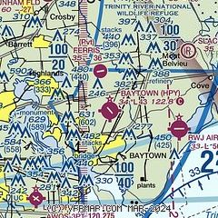
|
| Airport distance calculator |
|---|
|
|
| Sunrise and sunset |
|---|
|
Times for 18-May-2026
| | Local
(UTC-5) | | Zulu
(UTC) |
|---|
| Morning civil twilight | | 06:00 | | 11:00 |
| Sunrise | | 06:26 | | 11:26 |
| Sunset | | 20:06 | | 01:06 |
| Evening civil twilight | | 20:33 | | 01:33 |
|
| Current date and time |
|---|
| Zulu (UTC) | 19-May-2026 02:31:35 |
|---|
| Local (UTC-5) | 18-May-2026 21:31:35 |
|---|
|
| METAR |
|---|
KT41
9nm SW | 190215Z AUTO 15016KT 10SM SCT013 BKN018 OVC035 27/25 A2997 RMK AO2 T02700245
|
KEFD
16nm SW | 190154Z 14014KT 7SM BKN018 OVC030 27/24 A2993
|
KHOU
20nm SW | 190153Z 15011G21KT 8SM FEW017 BKN024 BKN036 27/24 A2994 RMK AO2 SLP141 T02720239 $
|
|
| TAF |
|---|
KHOU
20nm SW | 182031Z 1821/1918 15013G20KT P6SM BKN020 BKN050 FM190100 15012G19KT P6SM BKN015 BKN100 FM191000 15011KT P6SM OVC020 FM191600 16012G20KT P6SM SCT035 BKN045
|
|
| NOTAMs |
|---|
NOTAMs are issued by the DoD/FAA and will open in a separate window not controlled by AirNav.
|
|


