FAA INFORMATION EFFECTIVE 09 JULY 2026
Location
| FAA Identifier: | T00 |
| Lat/Long: | 29-46-11.3332N 094-39-48.5535W
29-46.188887N 094-39.809225W
29.7698148,-94.6634871
(estimated) |
| Elevation: | 21.2 ft. / 6.5 m (surveyed) |
| Variation: | 05E (1995) |
| From city: | 1 mile E of ANAHUAC, TX |
| Time zone: | UTC -5 (UTC -6 during Standard Time) |
| Zip code: | 77514 |
Airport Operations
| Airport use: | Open to the public |
| Activation date: | 10/1978 |
| Control tower: | no |
| ARTCC: | HOUSTON CENTER |
| FSS: | MONTGOMERY COUNTY FLIGHT SERVICE STATION |
| NOTAMs facility: | CXO (NOTAM-D service available) |
| Attendance: | MON-FRI 0800-1700 |
| Wind indicator: | lighted |
| Segmented circle: | yes |
| Lights: | DUSK-DAWN. MIRL RWY 12/30 PRESET LOW INTST; TO INCR INTST ACTVT - CTAF. |
| Beacon: | white-green (lighted land airport)
Operates sunset to sunrise. |
Airport Communications
| CTAF: | 122.9 |
| HOUSTON APPROACH: | 134.45 [0600-0000] |
| HOUSTON DEPARTURE: | 134.45 [0600-0000] |
| BLTWY RNAV DP: | 134.45 |
| BLUBELL STAR: | 124.225 |
| BORRN RNAV DP: | 134.45 |
| CESAN STAR: | 121.3 |
| DREMR DP: | 134.45 |
| HOODO RNAV DP: | 134.45 |
| HUDZY STAR: | 120.05 |
| INDIE RNAV DP: | 134.45 |
| KARRR RNAV DP: | 134.45 |
| LURIC DP: | 134.45 |
| MMALT RNAV DP: | 134.45 |
| OHIIO STAR: | 120.05 |
| SNDAY RNAV STAR: | 124.225 |
| STRYA DP: | 134.45 |
| STYCK DP: | 134.45 |
| TKNIQ STAR: | 119.625 |
| TSHIRT STAR: | 119.175 |
| TSHRT STAR: | 119.175 |
| WAPPL STAR: | 120.05 |
| WATFO DP: | 134.45 |
| WYLSN RNAV DP: | 134.45 |
| WX AWOS-3PT at T78 (19 nm N): | 120.775 (936-587-4150) |
Nearby radio navigation aids
| VOR radial/distance | | VOR name | | Freq | | Var |
|---|
| MHFr011/14.1 | | TRINITY VOR/DME | | 114.75 | | 07E |
| DASr177/25.2 | | DAISETTA VORTAC | | 116.90 | | 05E |
| VUHr014/31.9 | | SCHOLES VOR/DME | | 113.00 | | 06E |
| SBIr272/33.0 | | SABINE PASS VOR/DME | | 115.40 | | 07E |
| IAHr103/37.2 | | HUMBLE VORTAC | | 116.60 | | 05E |
| NDB name | | Hdg/Dist | | Freq | | Var | | ID |
|---|
| GOODHUE | | 226/29.6 | | 368 | | 07E | | GDE | --. -.. . |
Airport Services
| Fuel available: | 100LL JET-A JET-A1+
100LL:FUEL 24 HR SELF-SERVE. |
| Parking: | tiedowns |
| Bottled oxygen: | NONE |
| Bulk oxygen: | NONE |
Runway Information
Runway 12/30
| Dimensions: | 3005 x 60 ft. / 916 x 18 m |
| Surface: | asphalt, in poor condition |
| Weight bearing capacity: | |
| Runway edge lights: | medium intensity |
| Runway edge markings: | MKGS FADED. |
| RUNWAY 12 | | RUNWAY 30 |
| Latitude: | 29-46.363987N | | 29-46.053815N |
| Longitude: | 094-39.966058W | | 094-39.522763W |
| Elevation: | 20.4 ft. | | 20.4 ft. |
| Traffic pattern: | left | | right |
| Runway heading: | 124 magnetic, 129 true | | 304 magnetic, 309 true |
| Markings: | nonprecision, in poor condition | | nonprecision, in poor condition |
| Visual slope indicator: | 2-light PAPI on left (4.00 degrees glide path) | | |
| Touchdown point: | yes, no lights | | yes, no lights |
| Obstructions: | 34 ft. pole, 884 ft. from runway, 160 ft. left of centerline, 20:1 slope to clear | | 30 ft. tree, 880 ft. from runway, 280 ft. right of centerline, 22:1 slope to clear |
Runway 17/35
| Dimensions: | 1900 x 300 ft. / 579 x 91 m
MARKED 1660 FT LONG. |
| Surface: | turf, in good condition |
| RUNWAY 17 | | RUNWAY 35 |
| Latitude: | 29-46.313965N | | 29-46.000500N |
| Longitude: | 094-39.911733W | | 094-39.911733W |
| Elevation: | 20.0 ft. | | 20.0 ft. |
| Traffic pattern: | left | | right |
| Runway heading: | 175 magnetic, 180 true | | 355 magnetic, 000 true |
| Markings: | none, in good condition | | none, in good condition |
| Touchdown point: | yes, no lights | | yes, no lights |
| Obstructions: | 60 ft. trees, 890 ft. from runway, 90 ft. left of centerline, 14:1 slope to clear | | 17 ft. road, 230 ft. from runway, 13:1 slope to clear |
Airport Ownership and Management from official FAA records
| Ownership: | Publicly-owned |
| Owner: | CHAMBERS COUNTY
336 AIRPORT RD, PO BOX 938
ANAHUAC, TX 77514
Phone 409-267-2400 |
| Manager: | RONNIE BROWN
336 AIRPORT RD, PO BOX 938
ANAHUAC, TX 77514
Phone 409-267-2719 |
Additional Remarks
| - | RWY 17/35 SOFT WHEN WET. |
| - | RWY 17, PAPI RWY 12 IN RWY 17 APCH, DO NOT LAND BFR XNG RWY 12. |
| - | FOR CD CTC HOUSTON APCH AT 281-443-5844 TO CNL IFR CALL 281-443-5888. |
Instrument Procedures
NOTE: All procedures below are presented as PDF files. If you need a reader for these files, you should download the free Adobe Reader.NOT FOR NAVIGATION. Please procure official charts for flight.
FAA instrument procedures published for use from 09 July 2026 at 0901Z to 06 August 2026 at 0900Z.
STARs - Standard Terminal Arrivals |
|---|
| CESAN FOUR (RNAV) **CHANGED** | |
2 pages:
[1] [2] (405KB) |
| HUDZY FIVE **CHANGED** | |
2 pages:
[1] [2] (282KB) |
| OHIIO FOUR **CHANGED** | |
download (265KB) |
| SNDAY ONE (RNAV) **CHANGED** | |
download (233KB) |
| TKNIQ THREE (RNAV) **CHANGED** | |
2 pages:
[1] [2] (330KB) |
| TSHRT TWO **CHANGED** | |
2 pages:
[1] [2] (341KB) |
| WAPPL SEVEN (RNAV) **CHANGED** | |
2 pages:
[1] [2] (406KB) |
| WAPPL SEVEN (RNAV), CONT.2 **NEW** | |
download (283KB) |
IAPs - Instrument Approach Procedures |
|---|
| RNAV (GPS) RWY 12 | |
download (197KB) |
Departure Procedures |
|---|
| BLTWY SEVEN (RNAV) | |
download (153KB) |
| BORRN SIX (RNAV) | |
2 pages:
[1] [2] (299KB) |
| HOODO SEVEN (RNAV) | |
download (195KB) |
| INDIE EIGHT (RNAV) | |
download (180KB) |
| KARRR SEVEN (RNAV) | |
2 pages:
[1] [2] (247KB) |
| LURIC EIGHT (RNAV) | |
download (202KB) |
| MMALT SEVEN (RNAV) | |
download (207KB) |
| STRYA EIGHT (RNAV) | |
download (191KB) |
| STYCK EIGHT (RNAV) | |
download (178KB) |
| WATFO SIX (RNAV) | |
download (161KB) |
| WYLSN EIGHT (RNAV) | |
download (164KB) |
| NOTE: Special Take-Off Minimums/Departure Procedures apply | |
download (70KB) |
Other nearby airports with instrument procedures:
54T - RWJ Airpark (10 nm W)
T90 - Chambers County/Winnie Stowell Airport (12 nm E)
KHPY - Baytown Airport (15 nm W)
T78 - Liberty Municipal Airport (19 nm N)
T41 - La Porte Municipal Airport (22 nm W)
|
|

Road maps at:
MapQuest
Bing
Google
| Aerial photo |
|---|
WARNING: Photo may not be current or correct
 Photo taken 04-Mar-2007
on final for runway 30
Photo taken 04-Mar-2007
on final for runway 30
Do you have a better or more recent aerial photo of Chambers County Airport that you would like to share? If so, please send us your photo.
|
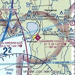
| Sectional chart |
|---|
|
| Airport distance calculator |
|---|
|
|
| Sunrise and sunset |
|---|
|
Times for 17-Jul-2026
| | Local
(UTC-5) | | Zulu
(UTC) |
|---|
| Morning civil twilight | | 06:04 | | 11:04 |
| Sunrise | | 06:30 | | 11:30 |
| Sunset | | 20:19 | | 01:19 |
| Evening civil twilight | | 20:46 | | 01:46 |
|
| Current date and time |
|---|
| Zulu (UTC) | 17-Jul-2026 10:02:09 |
|---|
| Local (UTC-5) | 17-Jul-2026 05:02:09 |
|---|
|
| METAR |
|---|
KT41
22nm W | 170955Z AUTO 16007KT 10SM SCT020 28/25 A3011 RMK AO2
|
KEFD
28nm W | 170954Z 12004KT 10SM FEW025 26/25 A3009
|
KBMT
29nm NE | 170955Z AUTO 00000KT 10SM CLR 25/24 A3012 RMK AO2 T02460235
|
KGLS
32nm S | 170952Z AUTO 17011KT 10SM FEW020 28/24 A3011 RMK AO2 SLP196 T02830244
|
KHOU
33nm W | 170953Z 14005KT 10SM FEW022 SCT250 27/25 A3009 RMK AO2 SLP194 T02670250
|
KLVJ
34nm SW | 170953Z AUTO 00000KT 9SM FEW021 27/25 A3011 RMK AO2 SLP196 T02670250
|
KBPT
35nm E | 170953Z AUTO 17003KT 10SM CLR 26/24 A3011 RMK AO2 SLP196 T02560244 $
|
KIAH
39nm W | 170953Z 16004KT 10SM SCT250 26/25 A3010 RMK AO2 SLP191 T02610250 $
|
K6R3
39nm NW | 170955Z AUTO 00000KT 5SM HZ CLR A3013 RMK AO2
|
|
| TAF |
|---|
KGLS
32nm S | 170520Z 1706/1806 16012KT P6SM FEW020
|
KHOU
33nm W | 170520Z 1706/1806 16004KT P6SM FEW025 BKN250 FM171400 18008KT P6SM SCT025 SCT035 SCT250 FM171800 17010KT P6SM SCT035 SCT050 SCT250 FM180200 16006KT P6SM FEW030 SCT250
|
KLVJ
34nm SW | 170520Z 1706/1806 VRB04KT P6SM FEW025 FM171400 17007KT P6SM SCT025 SCT035 FM171800 16009KT P6SM SCT035 SCT045 FM180200 16004KT P6SM SKC
|
KBPT
35nm E | 170525Z 1706/1806 16004KT P6SM BKN250 FM171500 18007KT P6SM BKN250
|
|
| NOTAMs |
|---|
NOTAMs are issued by the DoD/FAA and will open in a separate window not controlled by AirNav.
|
|

