FAA INFORMATION EFFECTIVE 16 APRIL 2026
Location
| FAA Identifier: | T90 |
| Lat/Long: | 29-49-08.0900N 094-25-51.8400W
29-49.134833N 094-25.864000W
29.8189139,-94.4310667
(estimated) |
| Elevation: | 24.2 ft. / 7.4 m (surveyed) |
| Variation: | 01E (2025) |
| From city: | 3 miles W of central business district of the associated city |
| Time zone: | UTC -5 (UTC -6 during Standard Time) |
| Zip code: | 77665 |
Airport Operations
| Airport use: | Open to the public |
| Activation date: | 07/1988 |
| Control tower: | no |
| ARTCC: | HOUSTON CENTER |
| FSS: | MONTGOMERY COUNTY FLIGHT SERVICE STATION |
| NOTAMs facility: | CXO (NOTAM-D service available) |
| Attendance: | UNATNDD |
| Wind indicator: | lighted |
| Segmented circle: | yes |
| Lights: | MIRL RWY 17/35 PRESET LOW INTST DUSK-2330, TO INCR INTST OR ACTVT AFT 2330 - CTAF. |
| Beacon: | white-green (lighted land airport)
Operates sunset to sunrise. |
Airport Communications
| CTAF: | 122.9 |
| HOUSTON APPROACH: | 121.3 [OPR 1200-0200Z++ MON-FRI; 1800-2300Z++ SUN; CLSD SAT AND HOL, OT CTC FORT WORTH CENTER 133.5 350.35.] |
| HOUSTON DEPARTURE: | 121.3 [OPR 1200-0200Z++ MON-FRI; 1800-2300Z++ SUN; CLSD SAT AND HOL, OT CTC FORT WORTH CENTER 133.5 350.35.] |
| WX AWOS-3PT at BMT (19 nm NE): | 118.425 (409-866-2832) |
Nearby radio navigation aids
| VOR radial/distance | | VOR name | | Freq | | Var |
|---|
| SBIr284/22.0 | | SABINE PASS VOR/DME | | 115.40 | | 07E |
| MHFr038/23.2 | | TRINITY VOR/DME | | 114.75 | | 07E |
| DASr148/24.9 | | DAISETTA VORTAC | | 116.90 | | 05E |
| NDB name | | Hdg/Dist | | Freq | | Var | | ID |
|---|
| GOODHUE | | 210/18.9 | | 368 | | 07E | | GDE | --. -.. . |
Airport Services
| Fuel available: | 100LL JET-A+
100LL:FUEL SELF-SVC. |
| Parking: | tiedowns |
Runway Information
Runway 17/35
| Dimensions: | 3600 x 75 ft. / 1097 x 23 m |
| Surface: | asphalt, in good condition |
| Runway edge lights: | medium intensity |
| RUNWAY 17 | | RUNWAY 35 |
| Latitude: | 29-49.431833N | | 29-48.837833N |
| Longitude: | 094-25.867333W | | 094-25.860500W |
| Elevation: | 24.2 ft. | | 22.6 ft. |
| Traffic pattern: | left | | left |
| Runway heading: | 178 magnetic, 179 true | | 358 magnetic, 359 true |
| Markings: | nonprecision, in fair condition | | nonprecision, in fair condition |
| Visual slope indicator: | 2-light PAPI on left (3.00 degrees glide path) | | 2-light PAPI on left (3.00 degrees glide path) |
| Touchdown point: | yes, no lights | | yes, no lights |
| Obstructions: | 47 ft. trees, 1380 ft. from runway, 250 ft. left of centerline, 25:1 slope to clear | | none |
Airport Ownership and Management from official FAA records
| Ownership: | Publicly-owned |
| Owner: | CHAMBERS CO COMMISSIONERS CT
404 WASHINGTON ST, PO BOX 939
ANAHUAC, TX 77514
Phone 409-267-2400 |
| Manager: | RONNIE BROWN
PO BOX 938
ANAHUAC, TX 77514
Phone 409-267-2719 |
Additional Remarks
| - | FOR CD CTC HOUSTON APCH AT 281-443-5844. TO CNL IFR CALL 281-443-5888. |
Instrument Procedures
NOTE: All procedures below are presented as PDF files. If you need a reader for these files, you should download the free Adobe Reader.NOT FOR NAVIGATION. Please procure official charts for flight.
FAA instrument procedures published for use from 16 April 2026 at 0901Z to 14 May 2026 at 0900Z.
IAPs - Instrument Approach Procedures |
|---|
| RNAV (GPS)-A | |
download (165KB) |
| NOTE: Special Take-Off Minimums/Departure Procedures apply | |
download (209KB) |
Other nearby airports with instrument procedures:
T00 - Chambers County Airport (12 nm W)
KBMT - Beaumont Municipal Airport (19 nm NE)
T78 - Liberty Municipal Airport (21 nm NW)
54T - RWJ Airpark (22 nm W)
KBPT - Jack Brooks Regional Airport (23 nm E)
|
|

Road maps at:
MapQuest
Bing
Google
| Aerial photo |
|---|
WARNING: Photo may not be current or correct
 Photo by Danny Schnautz
Photo taken 07-Nov-2020
looking northeast from 2,000
Photo by Danny Schnautz
Photo taken 07-Nov-2020
looking northeast from 2,000
Do you have a better or more recent aerial photo of Chambers County/Winnie Stowell Airport that you would like to share? If so, please send us your photo.
|
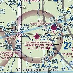
| Sectional chart |
|---|
|
| Airport distance calculator |
|---|
|
|
| Sunrise and sunset |
|---|
|
Times for 13-May-2026
| | Local
(UTC-5) | | Zulu
(UTC) |
|---|
| Morning civil twilight | | 06:01 | | 11:01 |
| Sunrise | | 06:27 | | 11:27 |
| Sunset | | 20:01 | | 01:01 |
| Evening civil twilight | | 20:27 | | 01:27 |
|
| Current date and time |
|---|
| Zulu (UTC) | 13-May-2026 18:35:07 |
|---|
| Local (UTC-5) | 13-May-2026 13:35:07 |
|---|
|
| METAR |
|---|
KBMT
19nm NE | 131815Z AUTO 31004KT 2 1/2SM HZ CLR 28/14 A3006 RMK AO2 VIS 1 1/2V5 T02820139
|
KBPT
22nm E | 131753Z 02009KT 10SM CLR 29/16 A3006 RMK AO2 SLP179 T02940156 10294 20178 58008
|
KT41
34nm W | 131815Z AUTO 05008KT 10SM CLR 30/14 A3008 RMK AO2 T03000136
|
KORG
36nm NE | 131815Z AUTO 01005KT 10SM CLR 29/14 A3008 RMK AO2 T02880144 PWINO
|
|
| TAF |
|---|
KBPT
22nm E | 131720Z 1318/1418 36007KT P6SM SKC FM140000 VRB03KT P6SM SKC FM140600 VRB02KT 5SM BR SKC FM141400 VRB05KT P6SM SKC
|
|
| NOTAMs |
|---|
NOTAMs are issued by the DoD/FAA and will open in a separate window not controlled by AirNav.
|
|

