FAA INFORMATION EFFECTIVE 25 DECEMBER 2025
Location
| FAA Identifier: | 54T |
| Lat/Long: | 29-45-42.8200N 094-50-52.5800W
29-45.713667N 094-50.876333W
29.7618944,-94.8479389
(estimated) |
| Elevation: | 33 ft. / 10 m (estimated) |
| Variation: | 05E (1985) |
| From city: | 7 miles E of BAYTOWN, TX |
| Time zone: | UTC -6 (UTC -5 during Daylight Saving Time) |
| Zip code: | 77520 |
Airport Operations
| Airport use: | Open to the public |
| Activation date: | 02/1977 |
| Control tower: | no |
| ARTCC: | HOUSTON CENTER |
| FSS: | MONTGOMERY COUNTY FLIGHT SERVICE STATION |
| NOTAMs facility: | CXO (NOTAM-D service available) |
| Attendance: | MON-FRI 0800-1800 |
| Wind indicator: | yes |
| Segmented circle: | no |
| Lights: | SS-SR |
| Beacon: | white-green (lighted land airport)
Operates sunset to sunrise. |
Airport Communications
| CTAF/UNICOM: | 122.7 |
| HOUSTON APPROACH: | 134.45 |
| HOUSTON DEPARTURE: | 134.45 |
| BLTWY RNAV DP: | 134.45 |
| BLUBELL STAR: | 124.225 |
| BORRN RNAV DP: | 134.45 |
| CESAN STAR: | 121.3 |
| DREMR DP: | 134.45 |
| HOODO RNAV DP: | 134.45 |
| HUDZY STAR: | 120.05 |
| KARRR RNAV DP: | 134.45 |
| LURIC DP: | 134.45 |
| MMALT RNAV DP: | 134.45 |
| OHIIO STAR: | 120.05 |
| SNDAY RNAV STAR: | 124.225 |
| STRYA DP: | 134.45 |
| STYCK DP: | 134.45 |
| TKNIQ STAR: | 119.625 |
| TSHIRT STAR: | 119.175 |
| TSHRT STAR: | 119.175 |
| WAPPL STAR: | 120.05 |
| WATFO DP: | 134.45 |
| WYLSN RNAV DP: | 134.45 |
| WX AWOS-3PT at T41 (13 nm SW): | 120.275 (281-471-2206) |
| WX AWOS-3 at EFD (19 nm SW): | 135.575 (713-847-4430) |
Nearby radio navigation aids
| VOR radial/distance | | VOR name | | Freq | | Var |
|---|
| MHFr331/14.0 | | TRINITY VOR/DME | | 114.75 | | 07E |
| DASr197/27.8 | | DAISETTA VORTAC | | 116.90 | | 05E |
| IAHr109/28.4 | | HUMBLE VORTAC | | 116.60 | | 05E |
| VUHr356/29.6 | | SCHOLES VOR/DME | | 113.00 | | 06E |
| NDB name | | Hdg/Dist | | Freq | | Var | | ID |
|---|
| GOODHUE | | 234/37.9 | | 368 | | 07E | | GDE | --. -.. . |
Airport Services
| Fuel available: | 100LL JET-A
100LL:FOR FUEL SERVICES CALL 281-383-2320. |
| Parking: | hangars and tiedowns |
| Airframe service: | NONE |
| Powerplant service: | NONE |
Runway Information
Runway 8/26
| Dimensions: | 5035 x 40 ft. / 1535 x 12 m
EAST 1100 FT 60 FT WIDE. |
| Surface: | asphalt, in fair condition |
| Weight bearing capacity: | |
| Runway edge lights: | low intensity
LIRL LCTD 15 FT FM RWY EDGE WEST, 4000 FT LGTD. |
| Runway edge markings: | DSPLCD THR MKGS NSTD, NRS 35 FT TALL, THR BAR 15 INS WIDE. |
| RUNWAY 8 | | RUNWAY 26 |
| Latitude: | 29-45.692283N | | 29-45.706400N |
| Longitude: | 094-51.266617W | | 094-50.314733W |
| Elevation: | 29.8 ft. | | 26.7 ft. |
| Traffic pattern: | left | | left |
| Runway heading: | 084 magnetic, 089 true | | 264 magnetic, 269 true |
| Displaced threshold: | no | | 939 ft. |
| Markings: | NSTD, in good condition | | NSTD, in good condition |
| Touchdown point: | yes, no lights | | yes, no lights |
| Obstructions: | 18 ft. bldg, 300 ft. from runway, 168 ft. left of centerline, 5:1 slope to clear | | 10 ft. road, 201 ft. from runway
+10 FT RD 0-200 FT FM THR 60 FT R CNTRLN; +4 FT FENCE 0-200 FT FM THR 92 FT R CNTRLN. |
Runway 14/32
| Dimensions: | 3532 x 100 ft. / 1077 x 30 m |
| Surface: | turf, in fair condition |
| Weight bearing capacity: | |
| RUNWAY 14 | | RUNWAY 32 |
| Latitude: | 29-45.980100N | | 29-45.488450N |
| Longitude: | 094-51.178733W | | 094-50.820383W |
| Elevation: | 33.0 ft. | | 28.0 ft. |
| Traffic pattern: | left | | left |
| Runway heading: | 143 magnetic, 148 true | | 323 magnetic, 328 true |
| Displaced threshold: | 340 ft. | | 600 ft. |
| Touchdown point: | yes, no lights | | yes, no lights |
| Obstructions: | 15 ft. road, 120 ft. left of centerline
APCH RATIO 15:1 TO DSPLCD THR OVER 36 FT BLDG, 565 FT DSTC, 45 FT L. | | 17 ft. road, 25 ft. from runway, 50 ft. both sides of centerline, 1:1 slope to clear |
Airport Ownership and Management from official FAA records
| Ownership: | Privately-owned |
| Owner: | RWJ PROPERTY OWNERS ASSOCIATION
15814 SUNDOWNER
MOUNT BELVIEU, TX 77580
Phone 281-573-9609 |
| Manager: | DENNIS J. COX
15506 SUNDOWNER
BEACH CITY, TX 77523
Phone 512-825-9771 |
Additional Remarks
| - | TWY TOO NARROW FOR SOME ACFT. |
| - | RWY 08 28 FT PLINE (MKD & LGTD), 468 FT FM RWY END. |
| - | FOR CD CTC HOUSTON APCH AT 281-443-5844 TO CNL IFR CALL 281-443-5888. |
Instrument Procedures
NOTE: All procedures below are presented as PDF files. If you need a reader for these files, you should download the free Adobe Reader.NOT FOR NAVIGATION. Please procure official charts for flight.
FAA instrument procedures published for use from 25 December 2025 at 0901z to 22 January 2026 at 0900z.
STARs - Standard Terminal Arrivals |
|---|
| CESAN FOUR (RNAV) | |
2 pages:
[1] [2] (403KB) |
| HUDZY FIVE | |
2 pages:
[1] [2] (281KB) |
| OHIIO FOUR | |
download (265KB) |
| SNDAY ONE (RNAV) | |
download (232KB) |
| TKNIQ THREE (RNAV) | |
2 pages:
[1] [2] (328KB) |
| TSHRT TWO | |
2 pages:
[1] [2] (339KB) |
| WAPPL SEVEN (RNAV) | |
2 pages:
[1] [2] (404KB) |
| WAPPL SEVEN (RNAV), CONT.2 | |
download (283KB) |
IAPs - Instrument Approach Procedures |
|---|
| RNAV (GPS)-A | |
download (162KB) |
Departure Procedures |
|---|
| BLTWY SEVEN (RNAV) | |
download (148KB) |
| BORRN SIX (RNAV) | |
2 pages:
[1] [2] (290KB) |
| HOODO SEVEN (RNAV) | |
download (191KB) |
| INDIE EIGHT (RNAV) | |
download (175KB) |
| KARRR SEVEN (RNAV) | |
2 pages:
[1] [2] (239KB) |
| LURIC EIGHT (RNAV) | |
download (199KB) |
| MMALT SEVEN (RNAV) | |
download (202KB) |
| STRYA EIGHT (RNAV) | |
download (187KB) |
| STYCK EIGHT (RNAV) | |
download (175KB) |
| WATFO SIX (RNAV) | |
download (158KB) |
| WYLSN EIGHT (RNAV) | |
download (161KB) |
| NOTE: Special Take-Off Minimums/Departure Procedures apply | |
download (118KB) |
Other nearby airports with instrument procedures:
KHPY - Baytown Airport (6 nm W)
T00 - Chambers County Airport (10 nm E)
T41 - La Porte Municipal Airport (13 nm SW)
KEFD - Ellington Airport (19 nm SW)
T78 - Liberty Municipal Airport (20 nm N)
|
|

Road maps at:
MapQuest
Bing
Google
| Aerial photo |
|---|
WARNING: Photo may not be current or correct
 Photo taken 20-Mar-2008
Do you have a better or more recent aerial photo of RWJ Airpark that you would like to share? If so, please send us your photo.
|
| Sectional chart |
|---|
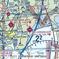
|
| Airport distance calculator |
|---|
|
|
| Sunrise and sunset |
|---|
|
Times for 14-Jan-2026
| | Local
(UTC-6) | | Zulu
(UTC) |
|---|
| Morning civil twilight | | 06:51 | | 12:51 |
| Sunrise | | 07:17 | | 13:17 |
| Sunset | | 17:40 | | 23:40 |
| Evening civil twilight | | 18:06 | | 00:06 |
|
| Current date and time |
|---|
| Zulu (UTC) | 14-Jan-2026 16:10:11 |
|---|
| Local (UTC-6) | 14-Jan-2026 10:10:11 |
|---|
|
| METAR |
|---|
KT41
13nm SW | 141555Z AUTO 28012KT 10SM CLR 15/06 A3005 RMK AO2 T01470064
|
KEFD
19nm SW | 141554Z 25012KT 10SM CLR 14/06 A3003
|
KHOU
24nm W | 141553Z 27014G21KT 10SM SCT250 14/06 A3004 RMK AO2 SLP177 T01440061
|
|
| TAF |
|---|
KEFD
19nm SW | 141200Z 1412/1518 VRB05KT 9999 SCT050 QNH3002INS BECMG 1419/1420 34010G25KT 9999 SKC QNH3001INS BECMG 1501/1502 33012KT 9999 FEW050 QNH3013INS TX18/1421Z TN07/1512Z
|
KHOU
24nm W | 141124Z 1412/1512 24006KT P6SM SCT080 FM141500 27010KT P6SM SCT250 FM141700 33015G27KT P6SM SKC FM150000 33010G20KT P6SM SKC FM150500 33010KT P6SM SKC
|
|
| NOTAMs |
|---|
NOTAMs are issued by the DoD/FAA and will open in a separate window not controlled by AirNav.
|
|

