FAA INFORMATION EFFECTIVE 19 FEBRUARY 2026
Location
| FAA Identifier: | PSX |
| Lat/Long: | 28-43-39.0000N 096-15-03.4000W
28-43.650000N 096-15.056667W
28.7275000,-96.2509444
(estimated) |
| Elevation: | 14.1 ft. / 4.3 m (surveyed) |
| Variation: | 03E (2015) |
| From city: | 3 miles NW of PALACIOS, TX |
| Time zone: | UTC -6 (UTC -5 during Daylight Saving Time) |
| Zip code: | 77465 |
Airport Operations
| Airport use: | Open to the public |
| Activation date: | 08/1943 |
| Control tower: | no |
| ARTCC: | HOUSTON CENTER |
| FSS: | MONTGOMERY COUNTY FLIGHT SERVICE STATION |
| NOTAMs facility: | PSX (NOTAM-D service available) |
| Attendance: | UNATNDD |
| Wind indicator: | lighted |
| Segmented circle: | yes |
| Lights: | MIRL RWY 13/31 PRESET ON LOW INTST; TO INCR INTST ACTVT - CTAF. |
| Beacon: | white-green (lighted land airport)
Operates sunset to sunrise. |
Airport Communications
| CTAF/UNICOM: | 122.8 |
| WX ASOS: | 118.025 (361-972-0101) |
- APCH/DEP CTL SVC PRVDD BY HOUSTON ARTCC (ZHU) ON FREQS 135.05/353.6 (VICTORIA RCAG).
Nearby radio navigation aids
| VOR radial/distance | | VOR name | | Freq | | Var |
|---|
| PSXr119/3.7 | | PALACIOS VORTAC | | 117.30 | | 08E |
| VCTr099/39.7 | | VICTORIA VOR/DME | | 109.00 | | 06E |
Airport Services
Runway Information
Runway 8/26
| Dimensions: | 5001 x 150 ft. / 1524 x 46 m |
| Surface: | concrete, in poor condition
TALL VEGETATION ON RWY. |
| Weight bearing capacity: | | Single wheel: | 46.0 | | Double wheel: | 58.0 | | Double tandem: | 105.0 |
|
| RUNWAY 8 | | RUNWAY 26 |
| Latitude: | 28-43.823265N | | 28-43.820233N |
| Longitude: | 096-15.725210W | | 096-14.788963W |
| Elevation: | 10.8 ft. | | 12.4 ft. |
| Traffic pattern: | left | | left |
| Runway heading: | 087 magnetic, 090 true | | 267 magnetic, 270 true |
| Markings: | , in poor condition | | , in poor condition |
| Touchdown point: | yes, no lights | | yes, no lights |
| Obstructions: | 18 ft. trees, 418 ft. from runway, 70 ft. left of centerline, 12:1 slope to clear
WINDMILL. | | 28 ft. tower, 688 ft. from runway, 290 ft. left of centerline, 17:1 slope to clear |
Runway 13/31
| Dimensions: | 5001 x 150 ft. / 1524 x 46 m |
| Surface: | concrete, in good condition |
| Weight bearing capacity: | | Single wheel: | 46.0 | | Double wheel: | 58.0 | | Double tandem: | 105.0 |
|
| Runway edge lights: | medium intensity |
| RUNWAY 13 | | RUNWAY 31 |
| Latitude: | 28-43.843450N | | 28-43.257858N |
| Longitude: | 096-15.441088W | | 096-14.781452W |
| Elevation: | 12.3 ft. | | 13.8 ft. |
| Traffic pattern: | left | | left |
| Runway heading: | 132 magnetic, 135 true | | 312 magnetic, 315 true |
| Markings: | nonprecision, in fair condition | | nonprecision, in fair condition |
| Runway end identifier lights: | yes | | yes |
| Touchdown point: | yes, no lights | | yes, no lights |
| Obstructions: | none | | 15 ft. tree, 463 ft. from runway, 300 ft. left and right of centerline, 17:1 slope to clear |
Runway 18/36
| Dimensions: | 5001 x 75 ft. / 1524 x 23 m |
| Surface: | concrete, in poor condition
TALL VEGETATION ON RWY. |
| Weight bearing capacity: | | Single wheel: | 46.0 | | Double wheel: | 58.0 | | Double tandem: | 105.0 |
|
| RUNWAY 18 | | RUNWAY 36 |
| Latitude: | 28-43.991812N | | 28-43.166562N |
| Longitude: | 096-14.802373W | | 096-14.805822W |
| Elevation: | 11.1 ft. | | 13.8 ft. |
| Traffic pattern: | left | | left |
| Runway heading: | 177 magnetic, 180 true | | 357 magnetic, 000 true |
| Markings: | basic, in fair condition | | basic, in fair condition |
| Touchdown point: | yes, no lights | | yes, no lights |
Airport Ownership and Management from official FAA records
| Ownership: | Publicly-owned |
| Owner: | CITY OF PALACIOS
PO BOX 845
PALACIOS, TX 77465
Phone 361-972-3605 |
| Manager: | MANUEL GUEVARA
PO BOX 845
PALACIOS, TX 77465
Phone 361-404-9909
MANUEL GUEVARA |
Additional Remarks
| - | VEGETATION ON TWY. |
| - | COURTESY CAR AVBL. |
| - | FOR CD IF UNA TO CTC ON FSS FREQ, CTC HOUSTON ARTCC AT 281-230-5622. |
| - | TWYS, RWYS 8/26, 18/36 UNMKD. |
Instrument Procedures
NOTE: All procedures below are presented as PDF files. If you need a reader for these files, you should download the free Adobe Reader.NOT FOR NAVIGATION. Please procure official charts for flight.
FAA instrument procedures published for use from 19 February 2026 at 0901Z to 19 March 2026 at 0900Z.
IAPs - Instrument Approach Procedures |
|---|
| RNAV (GPS) RWY 13 | |
download (239KB) |
| VOR RWY 13 | |
download (211KB) |
| NOTE: Special Alternate Minimums apply | |
download (134KB) |
| NOTE: Special Take-Off Minimums/Departure Procedures apply | |
download (92KB) |
Other nearby airports with instrument procedures:
KPKV - Calhoun County Airport (23 nm W)
26R - Jackson County Airport (24 nm NW)
KBYY - Bay City Regional Airport (25 nm NE)
KARM - Wharton Regional Airport (32 nm N)
KVCT - Victoria Regional Airport (36 nm W)
|
|

Road maps at:
MapQuest
Bing
Google
| Aerial photo |
|---|
WARNING: Photo may not be current or correct
 Photo taken 02-Jun-2012
looking east.
Photo taken 02-Jun-2012
looking east.
Do you have a better or more recent aerial photo of Palacios Municipal Airport that you would like to share? If so, please send us your photo.
|
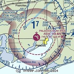
| Sectional chart |
|---|
|
| Airport distance calculator |
|---|
|
|
| Sunrise and sunset |
|---|
|
Times for 22-Feb-2026
| | Local
(UTC-6) | | Zulu
(UTC) |
|---|
| Morning civil twilight | | 06:34 | | 12:34 |
| Sunrise | | 06:58 | | 12:58 |
| Sunset | | 18:19 | | 00:19 |
| Evening civil twilight | | 18:43 | | 00:43 |
|
| Current date and time |
|---|
| Zulu (UTC) | 22-Feb-2026 19:40:32 |
|---|
| Local (UTC-6) | 22-Feb-2026 13:40:32 |
|---|
|
| METAR |
|---|
| KPSX | 221853Z AUTO 36017G24KT 10SM CLR 18/M03 A3056 RMK AO2 PK WND 03027/1817 SLP347 T01831033 $
|
|
| TAF |
|---|
KVCT
37nm W | 221720Z 2218/2318 02016G25KT P6SM SKC FM230000 VRB06KT P6SM SKC FM231500 04009KT P6SM SKC
|
|
| NOTAMs |
|---|
NOTAMs are issued by the DoD/FAA and will open in a separate window not controlled by AirNav.
|
|

