FAA INFORMATION EFFECTIVE 09 JULY 2026
Location
| FAA Identifier: | PKV |
| Lat/Long: | 28-39-11.9000N 096-40-57.8000W
28-39.198333N 096-40.963333W
28.6533056,-96.6827222
(estimated) |
| Elevation: | 32 ft. / 9.8 m (surveyed) |
| Variation: | 05E (2000) |
| From city: | 3 miles NW of PORT LAVACA, TX |
| Time zone: | UTC -5 (UTC -6 during Standard Time) |
| Zip code: | 77979 |
Airport Operations
| Airport use: | Open to the public |
| Control tower: | no |
| ARTCC: | HOUSTON CENTER |
| FSS: | MONTGOMERY COUNTY FLIGHT SERVICE STATION |
| NOTAMs facility: | PKV (NOTAM-D service available) |
| Attendance: | 0800-1700 |
| Wind indicator: | lighted |
| Segmented circle: | yes |
| Lights: | ACTVT MIRL RWY 14/32 - CTAF. |
| Beacon: | white-green (lighted land airport)
Operates sunset to sunrise. |
Airport Communications
| CTAF/UNICOM: | 122.8 |
| WX AWOS-3PT: | 118.275 (361-552-3060) |
| WX ASOS at VCT (17 nm NW): | PHONE 361-433-5979 |
- APCH/DEP CTL SVC PRVDD BY HOUSTON ARTCC (ZHU) ON FREQS 135.05/353.6 (VICTORIA RCAG).
Nearby radio navigation aids
| VOR radial/distance | | VOR name | | Freq | | Var |
|---|
| PSXr243/20.9 | | PALACIOS VORTAC | | 117.30 | | 08E |
| VCTr128/21.5 | | VICTORIA VOR/DME | | 109.00 | | 06E |
Airport Services
| Fuel available: | 100LL JET-A++
100LL:100LL AND JET A AVBL 24 HRS SELF SERVE. JET ALSO AVBL BY TRUCK. |
| Parking: | hangars and tiedowns |
| Airframe service: | MAJOR |
| Powerplant service: | MAJOR |
| Bottled oxygen: | NONE |
| Bulk oxygen: | HIGH/LOW |
Runway Information
Runway 14/32
| Dimensions: | 5004 x 75 ft. / 1525 x 23 m |
| Surface: | asphalt, in excellent condition |
| Weight bearing capacity: | |
| Runway edge lights: | medium intensity |
| RUNWAY 14 | | RUNWAY 32 |
| Latitude: | 28-39.577555N | | 28-38.905817N |
| Longitude: | 096-41.151127W | | 096-40.606763W |
| Elevation: | 29.9 ft. | | 28.5 ft. |
| Traffic pattern: | left | | right |
| Runway heading: | 139 magnetic, 144 true | | 319 magnetic, 324 true |
| Markings: | nonprecision, in good condition | | nonprecision, in good condition |
| Visual slope indicator: | 2-light PAPI on left (3.00 degrees glide path) | | 2-light PAPI on left (3.00 degrees glide path) |
| Touchdown point: | yes, no lights | | yes, no lights |
| Obstructions: | 13 ft. road, 560 ft. from runway, 290 ft. left and right of centerline, 27:1 slope to clear
22 FT TREES, 0-60 FT DSTC, 290 FT L. | | 15 ft. road, 475 ft. from runway, 290 ft. left and right of centerline, 18:1 slope to clear
22 FT TREES, 0-60==135 FT DSTC, 260 FT L. |
Runway 5/23
| Dimensions: | 2432 x 60 ft. / 741 x 18 m |
| Surface: | turf, in excellent condition |
| RUNWAY 5 | | RUNWAY 23 |
| Latitude: | 28-38.991252N | | 28-39.224778N |
| Longitude: | 096-41.320830W | | 096-40.950923W |
| Elevation: | 32.0 ft. | | 29.6 ft. |
| Traffic pattern: | left | | left |
| Runway heading: | 049 magnetic, 054 true | | 229 magnetic, 234 true |
| Displaced threshold: | no | | 428 ft. |
| Markings: | , in poor condition | | , in poor condition |
| Touchdown point: | yes, no lights | | yes, no lights |
| Obstructions: | 22 ft. tree, 141 ft. from runway, 70 ft. left of centerline, 6:1 slope to clear | | none |
Airport Ownership and Management from official FAA records
| Ownership: | Publicly-owned |
| Owner: | COUNTY OF CALHOUN
CALHOUN CO COURTHOUSE
PORT LAVACA, TX 77979
Phone 361-553-4600 |
| Manager: | LUDVIK SVETLIK
4876 FM 3084
PORT LAVACA, TX 77979
Phone 361-552-1228 |
Additional Remarks
| - | FOR CD CTC HOUSTON ARTCC AT 281-230-5622. |
| - | RC MODEL ACFT OPR AT RWY 5 END. |
Instrument Procedures
NOTE: All procedures below are presented as PDF files. If you need a reader for these files, you should download the free Adobe Reader.NOT FOR NAVIGATION. Please procure official charts for flight.
FAA instrument procedures published for use from 09 July 2026 at 0901Z to 06 August 2026 at 0900Z.
IAPs - Instrument Approach Procedures |
|---|
| RNAV (GPS) RWY 14 **CHANGED** | |
download (245KB) |
| RNAV (GPS) RWY 32 **CHANGED** | |
download (247KB) |
| VOR/DME-A **CHANGED** | |
download (217KB) |
| NOTE: Special Alternate Minimums apply | |
download (130KB) |
| NOTE: Special Take-Off Minimums/Departure Procedures apply | |
download (118KB) |
Other nearby airports with instrument procedures:
KVCT - Victoria Regional Airport (17 nm NW)
26R - Jackson County Airport (22 nm N)
KPSX - Palacios Municipal Airport (23 nm E)
KRKP - Aransas County Airport (39 nm SW)
KARM - Wharton Regional Airport (45 nm NE)
|
|

Road maps at:
MapQuest
Bing
Google
| Aerial photo |
|---|
WARNING: Photo may not be current or correct
 Taken in the Winter of 2006
Do you have a better or more recent aerial photo of Calhoun County Airport that you would like to share? If so, please send us your photo.
|
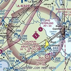
| Sectional chart |
|---|
|
| Airport distance calculator |
|---|
|
|
| Sunrise and sunset |
|---|
|
Times for 19-Jul-2026
| | Local
(UTC-5) | | Zulu
(UTC) |
|---|
| Morning civil twilight | | 06:16 | | 11:16 |
| Sunrise | | 06:42 | | 11:42 |
| Sunset | | 20:24 | | 01:24 |
| Evening civil twilight | | 20:50 | | 01:50 |
|
| Current date and time |
|---|
| Zulu (UTC) | 19-Jul-2026 12:16:02 |
|---|
| Local (UTC-5) | 19-Jul-2026 07:16:02 |
|---|
|
| METAR |
|---|
| KPKV | 191155Z AUTO 00000KT 4SM BR CLR 25/25 A3000 RMK AO2 T02500250 10258 20249 53008
|
KVCT
18nm NW | 191151Z 15005KT 6SM BR FEW020 24/24 A3002 RMK AO2 SLP164 T02440239 10256 20239 53006
|
|
| TAF |
|---|
KVCT
18nm NW | 190520Z 1906/2006 16007KT P6SM FEW025 TEMPO 1909/1913 5SM BR BKN025 FM192200 16012KT P6SM FEW030 FM200200 15008KT P6SM SKC
|
|
| NOTAMs |
|---|
NOTAMs are issued by the DoD/FAA and will open in a separate window not controlled by AirNav.
|
|

