FAA INFORMATION EFFECTIVE 30 OCTOBER 2025
Location
| FAA Identifier: | BAB |
| Lat/Long: | 39-08-09.9628N 121-26-11.7131W
39-08.166047N 121-26.195218W
39.1361008,-121.4365870
(estimated) |
| Elevation: | 112.9 ft. / 34.4 m (surveyed) |
| Variation: | 16E (1985) |
| From city: | 6 miles E of MARYSVILLE, CA |
| Time zone: | UTC -8 (UTC -7 during Daylight Saving Time) |
| Zip code: | 95903 |
Airport Operations
| Airport use: | Private use. Permission required prior to landing |
| Activation date: | 01/1960 |
| Control tower: | yes |
| ARTCC: | OAKLAND CENTER |
| FSS: | RANCHO MURIETA FLIGHT SERVICE STATION |
| NOTAMs facility: | BAB (NOTAM-D service available) |
| Attendance: | ALL
OPR H24 FR 1400Z++ MON THRU 0600Z++ SAT (2200L FRI), AND/OR BY NOTAM; CLSD WKEND AND HOL, OPENING AT 1400Z++ THE NEXT DUTY DAY. |
| Pattern altitude: | TFC PAT: RECTANGULAR PAT 1100 FT; OVHD PAT 2100 FT. FTR TYPE ACFT FLY RP RWY 15. |
| Wind indicator: | yes |
| Segmented circle: | no |
| Lights: | SS-SR |
| Beacon: | white-white-green (lighted military airport)
Operates sunset to sunrise. |
| International operations: | customs landing rights airport |
Airport Communications
| ATIS: | 124.55 273.5 ;OPR DUR WG OPR |
| BEALE GROUND: | 121.6 257.75 [OPR H24 FR 1400Z++ MON THRU 0600Z++ SAT, AND/OR BY NOTAM; CLSD WKEND AND HOL.] |
| BEALE TOWER: | 119.4 284.75 [OPR H24 FR 1400Z++ MON THRU 0600Z++ SAT, AND/OR BY NOTAM; CLSD WKEND AND HOL.] |
| NORCAL APPROACH: | 125.4 |
| NORCAL DEPARTURE: | 125.4 |
| CLASS C: | 125.4 |
| COMD POST: | 311.0 ;WING CMD POST 321.0 ;WING CMD POST |
| EMERG: | 121.5 243.0 |
| PTD: | 141.1 372.2 |
| SOF: | 139.6 240.225 |
| WX ASOS at MYV (7 nm W): | 118.475 (530-742-0695) |
| WX AWOS-3 at LHM (14 nm S): | 124.25 (916-645-0698) |
| WX AWOS-3 at AUN (20 nm SE): | 119.375 (530-888-8934) |
- WING COMD POST - 321.0 311.0 (321.0 INBD ACFT CTC COMD POST 35 MIN PRIOR ETA WITH INTENTIONS.)
- PTD-141.1 FOR USE ONLY WITHIN 16.2 NM, 15,000 FT OR BLW.
- RADAR - PAR - NO NOTAM MP: 1500-1730Z++ MON-FRI.
Nearby radio navigation aids
| VOR radial/distance | | VOR name | | Freq | | Var |
|---|
| MYVr055/6.7 | | MARYSVILLE VOR/DME | | 110.80 | | 16E |
| ILAr064/27.8 | | WILLIAMS VORTAC | | 114.40 | | 18E |
| MCCr340/28.2 | | MC CLELLAN VOR/DME | | 109.20 | | 17E |
Airport Services
| Parking: | hangars |
| Airframe service: | MINOR |
| Powerplant service: | MINOR |
| Bottled oxygen: | LOW |
| Bulk oxygen: | LOW |
Runway Information
Runway 15/33
| Dimensions: | 12001 x 300 ft. / 3658 x 91 m
RWY 300 FT WIDE MARKED AT 200 FT; FULL 300 FT WIDTH USBL. |
| Surface: | concrete/grooved |
| Weight bearing capacity: | |
| Runway edge lights: | high intensity |
| RUNWAY 15 | | RUNWAY 33 |
| Latitude: | 39-09.102622N | | 39-07.229470N |
| Longitude: | 121-26.601072W | | 121-25.789365W |
| Elevation: | 112.7 ft. | | 105.1 ft. |
| Traffic pattern: | left | | left |
| Runway heading: | 145 magnetic, 161 true | | 325 magnetic, 341 true |
| Markings: | precision, in good condition | | precision, in good condition |
| Visual slope indicator: | 4-light PAPI on left (2.75 degrees glide path) | | 4-light PAPI on left (3.00 degrees glide path) |
| RVR equipment: | touchdown | | touchdown |
| Approach lights: | ALSF1: standard 2,400 foot high intensity approach lighting system with centerline sequenced flashers (category I) | | ALSF1: standard 2,400 foot high intensity approach lighting system with centerline sequenced flashers (category I) |
| Runway end identifier lights: | no | | no |
| Touchdown point: | yes, no lights | | yes, no lights |
| Instrument approach: | LOC/GS | | LOC/GS |
Airport Ownership and Management from official FAA records
| Ownership: | U.S. Air Force |
| Owner: | USAF
BEALE AFB
MARYSVILLE, CA 95903 |
| Manager: | BASE OPERATIONS (USAF)
9TH CBAT SUP GP (SAC) BEALE AFB
MARYSVILLE, CA 95903
Phone 530-634-4823 |
Additional Remarks
| - | BEARING STRENGTH RWY 15/33: S160 T300 ST175 ST175 SBTT620 TT490 TDT840. |
| - | CSTMS/AG/IMG: 24 HR PN RQR FOR CSTMS AND AG. |
| - | MISC: TRAN ACFT EXP PROGRESSIVE TAXI. NO COMSEC MATERIAL AVBL. TRAN AIRCREW SHOULD PLAN TO ARR WITH APPROPRIATE COMSEC TO COMPLETE ENTIRE MSN. RWY 15-33 GROOVED. CLASS C AIRSPACE CONT. |
| - | RWY LGTS: RY 15, SF. |
| - | CAUTION: BEALE AFB IS LCTD ON A MAJ MIGRATORY BIRD FLYWAY. |
| - | BEARING STRENGTH RWY 15/33: S81, T122, ST175, SBTT590, TT490, TDT840. |
| - | PMSV METRO: WX OBSN AVBL H24 VIA AUTO OBSN SYS; WX SVC AVBL 1 HR PRIOR TO AFLD OPR HRS AND DUR FCST SEVERE WX DSN 368-9134, C530-634-9134. DUR WX FLT CLOSURES REMOTE BRIEFING SVC AVBL FROM 25 OP WX SQ DSN 228-6598/6599/6588. |
| - | JASU: (AM32A-60A) (A/M32A-86) 7(MC-1A) (MC-2A). |
| - | PMSV METRO: WHEN AUTO OBSN SYS INOP, OBST FR 325-060 DEG, 080-220 DEG, AND 245-280 DEG MAY IMPACT PREVAILING VIS. |
| - | CAUTION: USE EXTREME CAUTION FOR UNMANNED ACFT ACT IN VCNTY OF BEALE AFB. |
| - | CSTMS/AG/IMG: LTD CSTMS/AG AVBL TO MIL ACFT ONLY, 24 HR PN RQR. CTC AFLD MGT AT C530-634-2002 OR DSN 368-2002. |
| - | ATIS: OPR WHEN AERODROME IS OPEN. |
| - | FOR CD WHEN ATCT IS CLSD CTC NORCAL APCH AT 916-361-6874 |
| - | MISC: NO SPACE-A PAX SUPPORT AVBL ON WKENDS, HOL, AND ACC FAMILY DAYS. |
| - | RSTD: VIP PRKG RSTD TO ACFT WITH WINGSPAN 85 FT OR LESS. LRGR DV ACFT WILL PARK ON CARGO SPOTS. |
| - | MISC: WX SVC AVBL H24. CURRENT WX OBSN AVBL VIA ATIS OR CTC ATC. |
| - | FUEL: J8. |
| - | SVC TRAN ALERT: LAV CART AVBL FOR TSNT ACFT WITH PRIOR CDN. AIRCREW WILL HAVE TO PERFORM THEIR OWN LAV SVC AND CLEANUP. |
| - | SVC TRAN ALERT: NO POTABLE WATER OR ICE SVC. |
| - | AFRC: 940TH COMD POST, DSN 368-1960, C530-634-1960. |
| - | MISC: FOR SUPPORT OUTSIDE OF AIRFIELD OPR HRS (I.E., WKENDS, WING DOWN DAYS AND HOL) CTC BEALE 9RW COMMAND POST, DSN 368-5700, C530-634-5700. |
| - | MISC: STORAGE OF CLASSIFIED MTRL UNAVBL AT AIRFIELD MGMT; CTC COMMAND POST DSN 368-5700, C530-634-5700, H24 PRIOR. |
| - | FLUID: W SP LPOX LOX. |
| - | RWYLGTS: RY 33, SF. |
| - | OIL: O-128-133-148. |
| - | TRAN ALERT: SVC AVBL 1500-0600Z++ MON-FRI EXC FEDERAL HOL. ACFT THAT ARR AFTER 0600Z++ WILL NOT BE SVCD UNTIL NEXT DUTY DAY. FLEET SVC AVBL, 24 HR PN. |
| - | RSTD: PPR 24 HR PN, CTC BASE OPS DSN 368-2002/9120, C530-634-2002/9120. ISSUED PPR VALID 1 HR +/- ETA, EARLY/LATE ARR/DEP MUST RE-COORD. |
| - | RSTD: NO UNANNOUNCED ACFT PRACTICE APCH. INBOUND TSNT ACFT OBTAIN APVL FROM CTL TWR DSN 368-9140 FOR ACFT PRACTICE APCH PRIOR TO FLT. LTD PRKG AVBL. |
Instrument Procedures
NOTE: All procedures below are presented as PDF files. If you need a reader for these files, you should download the free Adobe Reader.NOT FOR NAVIGATION. Please procure official charts for flight.
FAA instrument procedures published for use from 30 October 2025 at 0901Z to 27 November 2025 at 0900Z.
IAPs - Instrument Approach Procedures |
|---|
| HI-ILS OR LOC Z RWY 15 | |
download (112KB) |
| HI-ILS OR LOC Z RWY 33 | |
download (110KB) |
| ILS OR LOC Y RWY 15 | |
download (89KB) |
| ILS OR LOC Y RWY 33 | |
download (104KB) |
| RNAV (GPS) RWY 15 | |
download (91KB) |
| RNAV (GPS) RWY 33 | |
download (87KB) |
| HI-TACAN Z RWY 15 | |
download (131KB) |
| HI-TACAN Z RWY 33 | |
download (101KB) |
| TACAN Y RWY 15 | |
download (85KB) |
| TACAN Y RWY 33 | |
download (100KB) |
Departure Procedures |
|---|
| PYNUN SEVEN | |
download (94KB) |
| NOTE: Special Take-Off Minimums/Departure Procedures apply | |
download (354KB) |
Other nearby airports with instrument procedures:
KMYV - Yuba County Airport (7 nm W)
KLHM - Lincoln Regional Airport/Karl Harder Field (14 nm S)
KAUN - Auburn Municipal Airport (20 nm SE)
KGOO - Nevada County Airport (21 nm E)
KOVE - Oroville Municipal Airport (23 nm N)
|
|

Road maps at:
MapQuest
Bing
Google
| Aerial photo |
|---|
WARNING: Photo may not be current or correct
 Photo by Chris Leipelt
Photo taken 12-Feb-2017
looking southeast.
Photo by Chris Leipelt
Photo taken 12-Feb-2017
looking southeast.
Do you have a better or more recent aerial photo of Beale Air Force Base that you would like to share? If so, please send us your photo.
|
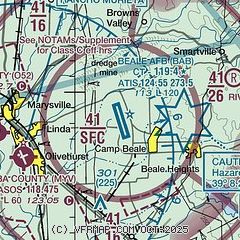
| Sectional chart |
|---|
|
 Download PDF
of official airport diagram from the FAA
| Airport distance calculator |
|---|
|
|
| Sunrise and sunset |
|---|
|
Times for 21-Nov-2025
| | Local
(UTC-8) | | Zulu
(UTC) |
|---|
| Morning civil twilight | | 06:28 | | 14:28 |
| Sunrise | | 06:57 | | 14:57 |
| Sunset | | 16:47 | | 00:47 |
| Evening civil twilight | | 17:16 | | 01:16 |
|
| Current date and time |
|---|
| Zulu (UTC) | 21-Nov-2025 08:55:56 |
|---|
| Local (UTC-8) | 21-Nov-2025 00:55:56 |
|---|
|
| METAR |
|---|
| KBAB | 210836Z 16003KT 1/8SM R33/0600V0900FT FG BKN001 OVC011 08/07 A2993 RMK TWR VIS 1/2SM SLP138 $
|
KMYV
6nm W | 210835Z AUTO 16003KT 3/4SM BR VV002 08/08 A2995 RMK AO2 T00830078 $
|
KLHM
14nm S | 210835Z AUTO 00000KT 3/4SM BKN002 BKN014 OVC021 09/09 A2995 RMK AO1
|
KAUN
20nm SE | 210835Z AUTO 11005KT 10SM OVC010 08/08 A2995 RMK A01
|
|
| TAF |
|---|
| KBAB | 210800Z 2108/2209 VRB04KT 0100 FG SKC QNH2994INS BECMG 2110/2111 VRB04KT 3200 BR SKC QNH2996INS BECMG 2113/2114 36010G15KT 4800 BR SKC QNH2998INS BECMG 2123/2124 30012KT 9999 NSW SKC QNH3000INS BECMG 2204/2205 14006KT 4800 BR SCT010 QNH3003INS TX19/2122Z TN07/2115Z
|
|
| NOTAMs |
|---|
NOTAMs are issued by the DoD/FAA and will open in a separate window not controlled by AirNav.
|
|


