FAA INFORMATION EFFECTIVE 09 JULY 2026
Location
| FAA Identifier: | BCE |
| Lat/Long: | 37-42-23.2090N 112-08-44.8790W
37-42.386817N 112-08.747983W
37.7064469,-112.1457997
(estimated) |
| Elevation: | 7589.9 ft. / 2313.4 m (surveyed) |
| Variation: | 14E (1980) |
| From city: | 4 miles N of BRYCE CANYON, UT |
| Time zone: | UTC -6 (UTC -7 during Standard Time) |
| Zip code: | 84759 |
Airport Operations
| Airport use: | Open to the public |
| Activation date: | 11/1938 |
| Control tower: | no |
| ARTCC: | SALT LAKE CITY CENTER |
| FSS: | CEDAR CITY FLIGHT SERVICE STATION |
| NOTAMs facility: | BCE (NOTAM-D service available) |
| Attendance: | 0800-1630 |
| Wind indicator: | lighted |
| Segmented circle: | yes |
| Lights: | ACTVT REIL RWY 03 & 21; PAPI RWY 03 & 21; MIRL RWY 03/21 - CTAF. |
| Beacon: | white-green (lighted land airport)
Operates sunset to sunrise. |
Airport Communications
| CTAF/UNICOM: | 122.8 |
| WX ASOS: | 135.475 (435-834-5270) |
| WX AWOS-3 at U55 (14 nm NW): | 133.125 (435-676-8784) |
- APCH/DEP CTL SVC PRVDD BY SALT LAKE CITY ARTCC (ZLC) ON FREQS 133.6/269.25 (BRYCE CANYON RCAG).
Nearby radio navigation aids
| VOR radial/distance | | VOR name | | Freq | | Var |
|---|
| BCEr067/7.6 | | BRYCE CANYON VORTAC | | 112.80 | | 15E |
Airport Services
| Fuel available: | 100LL JET-A
100LL:AFT HRS FUEL CALL 435-690-9498. $50 CALL-IN FEE. |
| Parking: | tiedowns |
| Airframe service: | NONE |
| Powerplant service: | NONE |
| Bottled oxygen: | NONE |
| Bulk oxygen: | NONE |
Runway Information
Runway 3/21
| Dimensions: | 7395 x 75 ft. / 2254 x 23 m |
| Surface: | asphalt/porous friction courses, in good condition |
| Weight bearing capacity: | |
| Runway edge lights: | medium intensity |
| RUNWAY 3 | | RUNWAY 21 |
| Latitude: | 37-41.969342N | | 37-42.804238N |
| Longitude: | 112-09.306058W | | 112-08.189813W |
| Elevation: | 7589.9 ft. | | 7553.6 ft. |
| Traffic pattern: | left | | left |
| Runway heading: | 033 magnetic, 047 true | | 213 magnetic, 227 true |
| Markings: | nonprecision, in fair condition | | nonprecision, in fair condition |
| Visual slope indicator: | 2-light PAPI on left (3.00 degrees glide path) | | 2-light PAPI on left (3.00 degrees glide path) |
| Runway end identifier lights: | yes | | yes |
| Touchdown point: | yes, no lights | | yes, no lights |
| Obstructions: | 13 ft. road, 615 ft. from runway, 133 ft. both sides of centerline, 30:1 slope to clear | | none |
Airport Ownership and Management from official FAA records
| Ownership: | Publicly-owned |
| Owner: | GARFIELD COUNTY
55 S MAIN ST., P.O. BOX 77
PANGUITCH, UT 84759
Phone 435-676-8826 |
| Manager: | TYE RAMSAY
450 NORTH AIRPORT ROAD, PO BOX 640037
BRYCE, UT 84764
Phone 435-834-5239 |
Additional Remarks
| - | FOR CD IF UNA TO CTC ON FSS FREQ, CTC SALT LAKE ARTCC AT 801-320-2568. |
Instrument Procedures
NOTE: All procedures below are presented as PDF files. If you need a reader for these files, you should download the free Adobe Reader.NOT FOR NAVIGATION. Please procure official charts for flight.
FAA instrument procedures published for use from 09 July 2026 at 0901Z to 06 August 2026 at 0900Z.
IAPs - Instrument Approach Procedures |
|---|
| RNAV (GPS) RWY 03 | |
download (220KB) |
| RNAV (GPS) RWY 21 | |
download (266KB) |
|
|---|
| BRYCE TWO (OBSTACLE) (RNAV) | |
download (202KB) |
| NOTE: Special Take-Off Minimums/Departure Procedures apply | |
download (113KB) |
Other nearby airports with instrument procedures:
U55 - Panguitch Municipal Airport (14 nm NW)
1L7 - Escalante Municipal Airport (27 nm E)
U52 - Beaver Municipal Airport (40 nm NW)
KCDC - Cedar City Regional Airport (45 nm W)
KKNB - Kanab Municipal Airport (46 nm SW)
|
|

Road maps at:
MapQuest
Bing
Google
| Aerial photo |
|---|
WARNING: Photo may not be current or correct
 Photo by Andreas Lauschke
Photo taken 28-Dec-2024
looking west.
Photo by Andreas Lauschke
Photo taken 28-Dec-2024
looking west.
Do you have a better or more recent aerial photo of Bryce Canyon Airport that you would like to share? If so, please send us your photo.
|
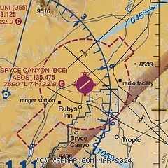
| Sectional chart |
|---|
|
| Airport distance calculator |
|---|
|
|
| Sunrise and sunset |
|---|
|
Times for 28-Jul-2026
| | Local
(UTC-6) | | Zulu
(UTC) |
|---|
| Morning civil twilight | | 06:01 | | 12:01 |
| Sunrise | | 06:30 | | 12:30 |
| Sunset | | 20:40 | | 02:40 |
| Evening civil twilight | | 21:10 | | 03:10 |
|
| Current date and time |
|---|
| Zulu (UTC) | 28-Jul-2026 20:53:53 |
|---|
| Local (UTC-6) | 28-Jul-2026 14:53:53 |
|---|
|
| METAR |
|---|
| KBCE | 281953Z AUTO 24006G15KT 10SM SCT090 28/06 A3032 RMK AO2 SLP130 T02830056
|
KU55
14nm NW | 282035Z AUTO 27007G15KT 250V320 10SM 32/05 A3022 RMK A01
|
|
| NOTAMs |
|---|
NOTAMs are issued by the DoD/FAA and will open in a separate window not controlled by AirNav.
|
|

