FAA INFORMATION EFFECTIVE 17 APRIL 2025
Location
| FAA Identifier: | U52 |
| Lat/Long: | 38-13-50.1000N 112-40-31.5000W
38-13.835000N 112-40.525000W
38.2305833,-112.6754167
(estimated) |
| Elevation: | 5863.3 ft. / 1787.1 m (surveyed) |
| Variation: | 14E (1985) |
| From city: | 4 miles SW of BEAVER, UT |
| Time zone: | UTC -6 (UTC -7 during Standard Time) |
| Zip code: | 84713 |
Airport Operations
| Airport use: | Open to the public |
| Activation date: | 05/1944 |
| Control tower: | no |
| ARTCC: | SALT LAKE CITY CENTER |
| FSS: | CEDAR CITY FLIGHT SERVICE STATION |
| NOTAMs facility: | CDC (NOTAM-D service available) |
| Attendance: | UNATNDD |
| Wind indicator: | yes |
| Segmented circle: | yes |
| Lights: | ACTVT REIL RWY 13 & 31; PAPI RWY 13 & 31; MIRL RWY 13/31 - CTAF. |
| Beacon: | white-green (lighted land airport)
Operates sunset to sunrise. |
Airport Communications
| CTAF: | 122.9 |
| WX AWOS-3PT: | 119.925 (435-438-5829) |
| WX ASOS at MLF (20 nm NW): | 135.025 (435-387-5201) |
- APCH/DEP CTL SVC PRVDD BY SALT LAKE CITY ARTCC (ZLC) ON FREQS 125.575/379.275 (CEDAR CITY RCAG).
Nearby radio navigation aids
| VOR radial/distance | | VOR name | | Freq | | Var |
|---|
| MLFr100/17.7 | | MILFORD VORTAC | | 112.10 | | 16E |
| EHKr019/32.4 | | ENOCH VOR/DME | | 117.30 | | 16E |
| BCEr317/36.9 | | BRYCE CANYON VORTAC | | 112.80 | | 15E |
Airport Services
| Fuel available: | 100LL
100LL:24 HR SELF SVC. |
| Parking: | tiedowns |
| Airframe service: | NONE |
| Powerplant service: | NONE |
| Bottled oxygen: | NONE |
| Bulk oxygen: | NONE |
Runway Information
Runway 13/31
| Dimensions: | 4984 x 75 ft. / 1519 x 23 m |
| Surface: | asphalt, in excellent condition |
| Weight bearing capacity: | |
| Runway edge lights: | medium intensity |
| RUNWAY 13 | | RUNWAY 31 |
| Latitude: | 38-14.252297N | | 38-13.558003N |
| Longitude: | 112-40.762922W | | 112-40.207952W |
| Elevation: | 5790.7 ft. | | 5863.3 ft. |
| Traffic pattern: | left | | left |
| Runway heading: | 134 magnetic, 148 true | | 314 magnetic, 328 true |
| Markings: | nonprecision, in good condition | | nonprecision, in good condition |
| Visual slope indicator: | 2-light PAPI on left (3.00 degrees glide path) | | 2-light PAPI on right (4.00 degrees glide path)
PAPI UNUSBL BYD 2.7 NM FM THLD DUE TO TRRN OCS PENETRATION AT 3.2 NM. |
| Runway end identifier lights: | yes | | yes |
| Touchdown point: | yes, no lights | | yes, no lights |
Runway 7/25
| Dimensions: | 2150 x 50 ft. / 655 x 15 m |
| Surface: | dirt, in fair condition |
| RUNWAY 7 | | RUNWAY 25 |
| Latitude: | 38-13.664172N | | 38-13.683223N |
| Longitude: | 112-40.839983W | | 112-40.391553W |
| Elevation: | 5842.3 ft. | | 5844.5 ft. |
| Traffic pattern: | left | | left |
| Runway heading: | 073 magnetic, 087 true | | 253 magnetic, 267 true |
| Markings: | none, in poor condition | | none, in poor condition |
| Touchdown point: | yes, no lights | | yes, no lights |
Airport Ownership and Management from official FAA records
| Ownership: | Publicly-owned |
| Owner: | BEAVER CITY
PO BOX 271
BEAVER, UT 84713
Phone 435-438-2451 |
| Manager: | JASON BROWN
30 WEST 300 NORTH, PO BOX 271
BEAVER, UT 84713
Phone (435) 421-1008 |
Additional Remarks
| A53-07 | 2 FT DELIMINATORS ACRS RWY 180 FT FM AER 25. |
| - | BIRDS ON & INVOF ARPT. |
| - | FOR CD CTC SALT LAKE ARTCC AT 801-320-2568. |
Instrument Procedures
NOTE: All procedures below are presented as PDF files. If you need a reader for these files, you should download the free Adobe Reader.NOT FOR NAVIGATION. Please procure official charts for flight.
FAA instrument procedures published for use from 17 April 2025 at 0901Z to 15 May 2025 at 0900z.
IAPs - Instrument Approach Procedures |
|---|
| RNAV (GPS)-A | |
download (257KB) |
| NOTE: Special Alternate Minimums apply | |
download (38KB) |
| NOTE: Special Take-Off Minimums/Departure Procedures apply | |
download (113KB) |
Other nearby airports with instrument procedures:
KMLF - Milford Municipal Airport/Ben and Judy Briscoe Field (20 nm NW)
U55 - Panguitch Municipal Airport (27 nm SE)
KCDC - Cedar City Regional Airport (38 nm SW)
KBCE - Bryce Canyon Airport (40 nm SE)
KRIF - Richfield Municipal Airport (40 nm NE)
|
|

Road maps at:
MapQuest
Bing
Google
| Aerial photo |
|---|
WARNING: Photo may not be current or correct

Do you have a better or more recent aerial photo of Beaver Municipal Airport that you would like to share? If so, please send us your photo.
|
| Sectional chart |
|---|
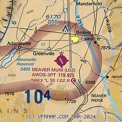
|
| Airport distance calculator |
|---|
|
|
| Sunrise and sunset |
|---|
|
Times for 25-Apr-2025
| | Local
(UTC-6) | | Zulu
(UTC) |
|---|
| Morning civil twilight | | 06:14 | | 12:14 |
| Sunrise | | 06:42 | | 12:42 |
| Sunset | | 20:15 | | 02:15 |
| Evening civil twilight | | 20:43 | | 02:43 |
|
| Current date and time |
|---|
| Zulu (UTC) | 25-Apr-2025 14:32:47 |
|---|
| Local (UTC-6) | 25-Apr-2025 08:32:47 |
|---|
|
| METAR |
|---|
KMLF
20nm NW | 251352Z AUTO 19003KT 10SM CLR 07/M02 A2989 RMK AO2 SLP085 T00671022
|
KCDC
38nm SW | 251353Z AUTO 16003KT 10SM CLR 11/M04 A2992 RMK AO2 SLP082 T01061039
|
|
| TAF |
|---|
KCDC
38nm SW | 251120Z 2512/2612 12006KT P6SM FEW200 FM251800 20020G30KT P6SM FEW200 FM260300 14009KT P6SM FEW200
|
KBCE
40nm SE | 251120Z 2512/2612 27007KT P6SM SCT200 FM251600 15014G22KT P6SM FEW200 FM251900 17016G26KT P6SM FEW090 FM260300 27007KT P6SM FEW090
|
|
| NOTAMs |
|---|
NOTAMs are issued by the DoD/FAA and will open in a separate window not controlled by AirNav.
|
|


