FAA INFORMATION EFFECTIVE 16 APRIL 2026
Location
| FAA Identifier: | BKD |
| Lat/Long: | 32-43-07.5220N 098-53-29.7470W
32-43.125367N 098-53.495783W
32.7187561,-98.8915964
(estimated) |
| Elevation: | 1284.2 ft. / 391.4 m (surveyed) |
| Variation: | 07E (1985) |
| From city: | 2 miles S of BRECKENRIDGE, TX |
| Time zone: | UTC -5 (UTC -6 during Standard Time) |
| Zip code: | 76424 |
Airport Operations
| Airport use: | Open to the public |
| Activation date: | 10/1937 |
| Control tower: | no |
| ARTCC: | FORT WORTH CENTER |
| FSS: | FORT WORTH FLIGHT SERVICE STATION |
| NOTAMs facility: | FTW (NOTAM-D service available) |
| Attendance: | MON-FRI 0800-1700
AFTR HRS ON CALL. |
| Wind indicator: | lighted |
| Segmented circle: | yes |
| Lights: | MIRL RWY 17/35 PRESET LOW INTST; TO INCR INTST & ACTVT PAPI RWYS 17 & 35 - CTAF. |
| Beacon: | white-green (lighted land airport)
Operates sunset to sunrise. |
Airport Communications
| CTAF/UNICOM: | 122.8 |
| WX AWOS-3: | 120.175 (254-559-5525) |
| WX AWOS-3PT at ETN (19 nm S): | 118.45 (254-631-0493) |
- APCH/DEP CTL SVC PRVDD BY FORT WORTH ARTCC (ZFW) ON FREQS 127.0/360.6 (MINERAL WELLS RCAG).
Airport Services
| Fuel available: | 100LL JET-A |
| Parking: | tiedowns |
| Airframe service: | MAJOR |
| Powerplant service: | MAJOR |
| Bottled oxygen: | NONE |
Runway Information
Runway 17/35
| Dimensions: | 5002 x 100 ft. / 1525 x 30 m |
| Surface: | asphalt, in good condition |
| Weight bearing capacity: | |
| Runway edge lights: | medium intensity |
| RUNWAY 17 | | RUNWAY 35 |
| Latitude: | 32-43.542198N | | 32-42.717308N |
| Longitude: | 098-53.459703W | | 098-53.453305W |
| Elevation: | 1255.0 ft. | | 1284.0 ft. |
| Traffic pattern: | left | | left |
| Runway heading: | 173 magnetic, 180 true | | 353 magnetic, 360 true |
| Markings: | nonprecision, in good condition | | nonprecision, in good condition |
| Visual slope indicator: | 2-light PAPI on left (3.00 degrees glide path) | | 2-light PAPI on left (3.00 degrees glide path) |
| Touchdown point: | yes, no lights | | yes, no lights |
| Obstructions: | 22 ft. trees, 528 ft. from runway, 275 ft. right of centerline, 14:1 slope to clear
APCH SLOPE 8:1 TO DSPLCD THR OVR 25 FT TREE, 218 FT DSTC. | | 17 ft. trees, 201 ft. from runway, 170 ft. right of centerline
21 FT TREES 89 DSTC, 130 FT R. |
Runway 13/31
| Dimensions: | 2401 x 50 ft. / 732 x 15 m |
| Surface: | asphalt, in fair condition |
| Weight bearing capacity: | |
| RUNWAY 13 | | RUNWAY 31 |
| Latitude: | 32-43.236880N | | 32-42.958892N |
| Longitude: | 098-53.730045W | | 098-53.396728W |
| Elevation: | 1246.9 ft. | | 1272.4 ft. |
| Traffic pattern: | left | | left |
| Runway heading: | 128 magnetic, 135 true | | 308 magnetic, 315 true |
| Displaced threshold: | no | | 120 ft. |
| Markings: | basic, in good condition | | basic, in good condition |
| Touchdown point: | yes, no lights | | yes, no lights |
| Obstructions: | 25 ft. trees, 305 ft. from runway, 250 ft. left of centerline, 4:1 slope to clear
4 FT FENCE 39-141 FT DSTC; 125 FT R. | | 20 ft. trees, 200 ft. from runway
5 FT FENCE 150 FT DSTC ACRS APCH; 20 FT TREES AND BRUSH 150 FT DSTC. |
Runway 4/22
| Dimensions: | 2398 x 50 ft. / 731 x 15 m |
| Surface: | asphalt, in fair condition |
| Weight bearing capacity: | |
| RUNWAY 4 | | RUNWAY 22 |
| Latitude: | 32-43.003028N | | 32-43.284392N |
| Longitude: | 098-53.674447W | | 098-53.345712W |
| Elevation: | 1263.0 ft. | | 1254.3 ft. |
| Traffic pattern: | left | | left |
| Runway heading: | 038 magnetic, 045 true | | 218 magnetic, 225 true |
| Markings: | basic, in good condition | | basic, in good condition |
| Touchdown point: | yes, no lights | | yes, no lights |
| Obstructions: | 20 ft. tree, 250 ft. from runway, 85 ft. right of centerline, 2:1 slope to clear
4 FT FENCE 150 FT DSTC ACRS APCH; 18 FT TREES 150 FT - 200 FT DSTC. | | 25 ft. trees, 400 ft. from runway, 8:1 slope to clear
10 FT BRUSH, FT 0-199 FT DSTC, 85 FT L. |
Airport Ownership and Management from official FAA records
| Ownership: | Publicly-owned |
| Owner: | STEPHENS COUNTY
STEPHENS COUNTY COURTHOUSE, 200 WEST WALKER
BRECKENRIDGE, TX 76424
Phone 254-559-2190 |
| Manager: | MICHAEL ROACH
STEPHENS COUNTY COURTHOUSE, 200 WEST WALKER
BRECKENRIDGE, TX 76424
Phone 254-559-2190 |
Instrument Procedures
NOTE: All procedures below are presented as PDF files. If you need a reader for these files, you should download the free Adobe Reader.NOT FOR NAVIGATION. Please procure official charts for flight.
FAA instrument procedures published for use from 16 April 2026 at 0901Z to 14 May 2026 at 0900Z.
IAPs - Instrument Approach Procedures |
|---|
| RNAV (GPS) RWY 17 | |
download (220KB) |
| RNAV (GPS) RWY 35 | |
download (223KB) |
| NOTE: Special Alternate Minimums apply | |
download (28KB) |
| NOTE: Special Take-Off Minimums/Departure Procedures apply | |
download (113KB) |
Other nearby airports with instrument procedures:
KETN - Eastland Municipal Airport (19 nm S)
T23 - Albany Municipal Airport (19 nm W)
KGZN - Gregory M Simmons Memorial Airport (22 nm S)
F35 - Possum Kingdom Airport (26 nm NE)
KRPH - Graham Municipal Airport (29 nm NE)
|
|

Road maps at:
MapQuest
Bing
Google
| Aerial photo |
|---|
WARNING: Photo may not be current or correct
 Photo by Sunandan Subramaniam
Photo taken 07-Sep-2008
Photo by Sunandan Subramaniam
Photo taken 07-Sep-2008
Do you have a better or more recent aerial photo of Stephens County Airport that you would like to share? If so, please send us your photo.
|
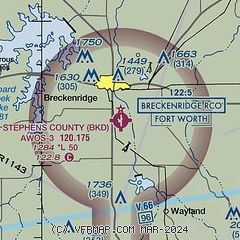
| Sectional chart |
|---|
|
| Airport distance calculator |
|---|
|
|
| Sunrise and sunset |
|---|
|
Times for 03-May-2026
| | Local
(UTC-5) | | Zulu
(UTC) |
|---|
| Morning civil twilight | | 06:21 | | 11:21 |
| Sunrise | | 06:48 | | 11:48 |
| Sunset | | 20:17 | | 01:17 |
| Evening civil twilight | | 20:44 | | 01:44 |
|
| Current date and time |
|---|
| Zulu (UTC) | 03-May-2026 07:00:22 |
|---|
| Local (UTC-5) | 03-May-2026 02:00:22 |
|---|
|
| METAR |
|---|
| KBKD | 030635Z AUTO 00000KT 7SM CLR 15/08 A3014 RMK AO2 T01530076
|
KETN
19nm S | 030635Z AUTO 19003KT 10SM CLR 12/08 A3016 RMK AO2 T01210078
|
|
| TAF |
|---|
KABI
44nm SW | 030520Z 0306/0406 19007KT P6SM SKC FM031600 19012G20KT P6SM SKC
|
|
| NOTAMs |
|---|
NOTAMs are issued by the DoD/FAA and will open in a separate window not controlled by AirNav.
|
|


