FAA INFORMATION EFFECTIVE 09 JULY 2026
Location
| FAA Identifier: | BZN |
| Lat/Long: | 45-46-38.0488N 111-09-00.9370W
45-46.634147N 111-09.015617W
45.7772358,-111.1502603
(estimated) |
| Elevation: | 4473.4 ft. / 1363.5 m (surveyed) |
| Variation: | 13E (2010) |
| From city: | 7 miles NW of BOZEMAN, MT |
| Time zone: | UTC -6 (UTC -7 during Standard Time) |
| Zip code: | 59714 |
Airport Operations
| Airport use: | Open to the public |
| Activation date: | 07/1942 |
| Control tower: | yes |
| ARTCC: | SALT LAKE CITY CENTER |
| FSS: | GREAT FALLS FLIGHT SERVICE STATION |
| NOTAMs facility: | BZN (NOTAM-D service available) |
| Attendance: | 0430-0100 |
| Wind indicator: | lighted |
| Segmented circle: | no |
| Lights: | WHEN ATCT CLSD ACTVT MALSR RWY 12 & 30; HIRL RWY 12/30; MIRL RWY 11/29 - CTAF. PAPI RWY 12 & 30 OPR CONSLY. |
| Beacon: | white-green (lighted land airport)
Operates sunset to sunrise. |
| Landing fee: | yes |
| Fire and rescue: | ARFF index C |
| International operations: | U.S. CUSTOMS AVBL 1600Z-2400Z THU-MON. |
Airport Communications
| CTAF: | 118.2 |
| UNICOM: | 122.95 |
| ATIS: | 135.425 |
| WX ASOS: | PHONE 406-388-4882 |
| BOZEMAN GROUND: | 121.8 [0530-0030] |
| BOZEMAN TOWER: | 118.2 [0530-0030] |
| BIG SKY APPROACH: | 118.975 |
| BIG SKY DEPARTURE: | 118.975 |
| CLEARANCE DELIVERY: | 124.05 |
- COMMUNICATIONS PRVDD BY GREAT FALLS RADIO ON FREQ 122.5 (BOZEMAN RCO).
- APCH/DEP CTL SVC PRVDD BY BIG SKY APCH CTL (BOI) ON FREQ 118.975/226.675 FM 0600-0015 LCL. SALT LAKE ARTCC (ZLC) PRVDD'S APCH/DEP SVC ON 118.975/226.675 ( BOZEMAN A RCAG) FM 0015-0600 LCL.
Nearby radio navigation aids
| VOR radial/distance | | VOR name | | Freq | | Var |
|---|
| BZN at field | | BOZEMAN VOR/DME | | 112.40 | | 18E |
| LVMr264/30.0 | | LIVINGSTON VOR/DME | | 116.10 | | 15E |
Airport Services
| Fuel available: | 100 100LL JET-A |
| Parking: | hangars and tiedowns |
| Airframe service: | MAJOR |
| Powerplant service: | MAJOR |
| Bottled oxygen: | HIGH/LOW |
| Bulk oxygen: | HIGH/LOW |
Runway Information
Runway 12/30
| Dimensions: | 8994 x 150 ft. / 2741 x 46 m |
| Surface: | asphalt/grooved, in good condition |
| Weight bearing capacity: | | Single wheel: | 120.0 | | Double wheel: | 250.0 | | Double tandem: | 550.0 | | Dual double tandem: | 1120.0 |
|
| Runway edge lights: | high intensity |
| RUNWAY 12 | | RUNWAY 30 |
| Latitude: | 45-47.285123N | | 45-46.224863N |
| Longitude: | 111-09.988903W | | 111-08.513370W |
| Elevation: | 4424.9 ft. | | 4462.3 ft. |
| Traffic pattern: | left | | left |
| Runway heading: | 123 magnetic, 136 true | | 303 magnetic, 316 true |
| Declared distances: | TORA:8994 TODA:8994 ASDA:8994 LDA:8994 | | TORA:8994 TODA:8994 ASDA:8994 LDA:8994 |
| Markings: | precision, in good condition | | precision, in good condition |
| Visual slope indicator: | 4-light PAPI on left (3.00 degrees glide path) | | 4-light PAPI on left (3.20 degrees glide path) |
| RVR equipment: | touchdown, midfield, rollout | | touchdown, midfield, rollout |
| Approach lights: | MALSR: 1,400 foot medium intensity approach lighting system with runway alignment indicator lights | | MALSR: 1,400 foot medium intensity approach lighting system with runway alignment indicator lights |
| Runway end identifier lights: | | | no |
| Touchdown point: | yes, no lights | | yes, no lights |
| Instrument approach: | ILS | | |
Runway 11/29
| Dimensions: | 5050 x 75 ft. / 1539 x 23 m |
| Surface: | asphalt/grooved, in good condition |
| Weight bearing capacity: | |
| Runway edge lights: | medium intensity |
| RUNWAY 11 | | RUNWAY 29 |
| Latitude: | 45-46.889333N | | 45-46.294000N |
| Longitude: | 111-09.129167W | | 111-08.301167W |
| Elevation: | 4441.8 ft. | | 4461.4 ft. |
| Traffic pattern: | left | | left |
| Runway heading: | 123 magnetic, 136 true | | 303 magnetic, 316 true |
| Declared distances: | TORA:5050 TODA:5050 ASDA:5050 LDA:5050 | | TORA:5050 TODA:5050 ASDA:5050 LDA:5050 |
| Markings: | basic, in good condition | | basic, in good condition |
| Visual slope indicator: | 4-light PAPI on left (3.00 degrees glide path) | | 4-light PAPI on left (3.00 degrees glide path) |
| Touchdown point: | yes, no lights | | yes, no lights |
Runway 3/21
| Dimensions: | 2650 x 75 ft. / 808 x 23 m |
| Surface: | asphalt/grooved, in good condition |
| Weight bearing capacity: | |
| RUNWAY 3 | | RUNWAY 21 |
| Latitude: | 45-46.130968N | | 45-46.435012N |
| Longitude: | 111-09.153152W | | 111-08.707232W |
| Elevation: | 4473.4 ft. | | 4454.7 ft. |
| Traffic pattern: | left | | left |
| Runway heading: | 033 magnetic, 046 true | | 213 magnetic, 226 true |
| Declared distances: | TORA:2650 TODA:2650 ASDA:2650 LDA:2650 | | TORA:2650 TODA:2650 ASDA:2650 LDA:2650 |
| Markings: | basic, in good condition | | basic, in good condition |
| Touchdown point: | yes, no lights | | yes, no lights |
Runway 11G/29G
| Dimensions: | 2802 x 80 ft. / 854 x 24 m |
| Surface: | turf, in good condition |
| Runway edge markings: | CONES. |
| Operational restrictions: | 240 FT S OF RWY 11/29; AVBL WHEN DRY WITH ATC APVL. |
| RUNWAY 11G | | RUNWAY 29G |
| Latitude: | 45-46.819833N | | 45-46.490000N |
| Longitude: | 111-09.112000W | | 111-08.651833W |
| Elevation: | 4444.2 ft. | | 4453.2 ft. |
| Traffic pattern: | left | | left |
| Runway heading: | 123 magnetic, 136 true | | 303 magnetic, 316 true |
| Markings: | NSTD | | NSTD |
| Touchdown point: | yes, no lights | | yes, no lights |
Airport Ownership and Management from official FAA records
| Ownership: | Publicly-owned |
| Owner: | GALLATIN AIRPORT AUTHORITY
850 GALLATIN FIELD RD, SUITE 6
BELGRADE, MT 59714
Phone 406-388-6632 |
| Manager: | BRIAN SPRENGER
850 GALLATIN FIELD RD, SUITE 6
BELGRADE, MT 59714
Phone 406-388-6632 |
Additional Remarks
| A39-12/30 | PCR VALUE: 1410/F/A/X/U |
| A39-11/29 | PCR VALUE: 260/F/A/X/U |
| A39-03/21 | PCR VALUE: 465/F/A/X/U |
| A30A-21 | LCTD BTN RWY 12/30 & TWY A; AVBL GTR THAN 12500 LB DAY/VFR ONLY. |
| A30A-03 | TKOF NA UNTIL CFMG NO TFC USING RWY 12. |
| A30A-12 | ARR & DEP OPS WHEN WIND LESS THAN 10 KT; OTR RWY MAY BE USED; EXPC DLA. |
| - | BIRDS INVOF ARPT. |
| - | STUDENT TRNG ACT WI 15 MI. |
| - | 180 DEG TURN NA ON TRML RAMP. |
| - | PILOTS CONDUCTING EFVS OPS; BE AWARE LED ALS IN USE RWY 12. |
| - | FOR CD WHEN ATCT CLSD CTC BIG SKY APCH AT 208-364-5860, WHEN ATCT AND APCH CLSD CTC SALT LAKE ARTCC AT 801-320-2568. |
| - | NOISE: TRAINING TRAFFIC - CHECK VOLUNTARY NOISE ABATEMENT PRO |
| - | SNOW REMOVAL EQUIP - CTAF. |
| - | COLD TEMPERATURE AIRPORT. ALTITUDE CORRECTION REQUIRED AT OR BELOW -21C. |
Instrument Procedures
NOTE: All procedures below are presented as PDF files. If you need a reader for these files, you should download the free Adobe Reader.NOT FOR NAVIGATION. Please procure official charts for flight.
FAA instrument procedures published for use from 09 July 2026 at 0901Z to 06 August 2026 at 0900Z.
STARs - Standard Terminal Arrivals |
|---|
| BGMAN ONE (RNAV) **NEW** | |
download (170KB) |
| EATZZ ONE (RNAV) **NEW** | |
download (163KB) |
| LOSST ONE (RNAV) **NEW** | |
download (179KB) |
| POWDA TWO (RNAV) **NEW** | |
download (140KB) |
| SUBKY ONE (RNAV) **NEW** | |
download (125KB) |
IAPs - Instrument Approach Procedures |
|---|
| ILS Y OR LOC Y RWY 12 | |
download (353KB) |
| ILS Z OR LOC Z RWY 12 | |
download (338KB) |
| ILS Y RWY 12 (SA CAT II) | |
download (327KB) |
| ILS Z RWY 12 (SA CAT II) | |
download (310KB) |
| RNAV (RNP) Z RWY 12 | |
download (335KB) |
| RNAV (RNP) Z RWY 30 | |
download (499KB) |
| RNAV (GPS) Y RWY 12 | |
download (335KB) |
| RNAV (GPS) Y RWY 30 | |
download (282KB) |
| RNAV (GPS)-A | |
download (612KB) |
| VOR RWY 12 | |
download (290KB) |
| NOTE: Special Alternate Minimums apply | |
download (211KB) |
Departure Procedures |
|---|
| BGSKY TWO (RNAV) | |
download (163KB) |
| BGSKY TWO (RNAV) | |
download (163KB) |
| BOBKT FIVE (RNAV) | |
download (166KB) |
| MEADO TWO (RNAV) | |
download (189KB) |
| MEADO TWO (RNAV) | |
download (189KB) |
| WHITEHALL FIVE | |
download (140KB) |
|
|---|
| BOZEMAN SIX (OBSTACLE) | |
download (155KB) |
| NOTE: Special Take-Off Minimums/Departure Procedures apply | |
download (376KB) |
Other nearby airports with instrument procedures:
KLVM - Mission Field Airport (30 nm E)
KEKS - Ennis - Big Sky Airport (37 nm SW)
7S6 - White Sulphur Springs Airport (44 nm N)
6S0 - Big Timber at Howard Field Airport (49 nm E)
KRVF - Ruby Valley Field Airport (50 nm W)
|
|

Road maps at:
MapQuest
Bing
Google
| Aerial photo |
|---|
WARNING: Photo may not be current or correct
 looking northwest.
Do you have a better or more recent aerial photo of Bozeman Yellowstone International Airport that you would like to share? If so, please send us your photo.
|
| Sectional chart |
|---|
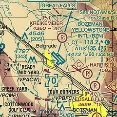
|
CAUTION: Diagram may not be current
 Download PDF
of official airport diagram from the FAA
| Airport distance calculator |
|---|
|
|
| Sunrise and sunset |
|---|
|
Times for 24-Jul-2026
| | Local
(UTC-6) | | Zulu
(UTC) |
|---|
| Morning civil twilight | | 05:24 | | 11:24 |
| Sunrise | | 06:00 | | 12:00 |
| Sunset | | 21:02 | | 03:02 |
| Evening civil twilight | | 21:38 | | 03:38 |
|
| Current date and time |
|---|
| Zulu (UTC) | 24-Jul-2026 23:40:48 |
|---|
| Local (UTC-6) | 24-Jul-2026 17:40:48 |
|---|
|
| METAR |
|---|
| KBZN | 242256Z 03008KT 10SM CLR 36/09 A2996 RMK AO2 SLP091 T03560094
|
|
| TAF |
|---|
| KBZN | 241745Z 2418/2524 VRB04KT P6SM SKC FM242100 27011G21KT P6SM FEW100 FM250200 23009KT P6SM SKC FM252000 VRB04KT P6SM SCT100
|
|
| NOTAMs |
|---|
NOTAMs are issued by the DoD/FAA and will open in a separate window not controlled by AirNav.
|
|


