FAA INFORMATION EFFECTIVE 16 APRIL 2026
Location
| FAA Identifier: | CEY |
| Lat/Long: | 36-39-52.4920N 088-22-21.9920W
36-39.874867N 088-22.366533W
36.6645811,-88.3727756
(estimated) |
| Elevation: | 577.3 ft. / 176.0 m (surveyed) |
| Variation: | 02W (2010) |
| From city: | 4 miles NW of MURRAY, KY |
| Time zone: | UTC -5 (UTC -6 during Standard Time) |
| Zip code: | 42071 |
Airport Operations
| Airport use: | Open to the public |
| Activation date: | 01/1962 |
| Control tower: | no |
| ARTCC: | MEMPHIS CENTER |
| FSS: | LOUISVILLE FLIGHT SERVICE STATION |
| NOTAMs facility: | LOU (NOTAM-D service available) |
| Attendance: | MON-SAT 0800-1700, ALL SUN 1300-1700
SVC AFT HR - AMGR. |
| Wind indicator: | lighted |
| Segmented circle: | yes |
| Lights: | ACTVT ODALS RWY 23; REIL RWY 05; PAPI RWY 05 & 23; MIRL RWY 05/23 - CTAF. |
| Beacon: | white-green (lighted land airport)
Operates sunset to sunrise. |
Airport Communications
| CTAF/UNICOM: | 122.7 |
| WX AWOS-3: | 119.975 (270-489-2424) |
| WX AWOS-3 at M25 (12 nm NW): | 120.625 (270-247-2094) |
| WX AWOS-3 at PHT (20 nm S): | 118.825 (731-644-0451) |
- APCH/DEP SVC PRVDD BY MEMPHIS ARTCC ON FREQS 133.65/292.15 (PADUCAH RCAG).
Nearby radio navigation aids
| VOR radial/distance | | VOR name | | Freq | | Var |
|---|
| CNGr130/30.4 | | CUNNINGHAM VOR/DME | | 113.10 | | 03E |
Airport Services
| Fuel available: | 100LL JET-A+ |
| Parking: | hangars and tiedowns |
| Airframe service: | MAJOR |
| Powerplant service: | MAJOR |
| Bottled oxygen: | NONE |
Runway Information
Runway 5/23
| Dimensions: | 6202 x 100 ft. / 1890 x 30 m |
| Surface: | asphalt/aggregate friction seal coat, in fair condition |
| Weight bearing capacity: | | PCN 37 /F/C/X/T | | Single wheel: | 95.0 | | Double wheel: | 131.0 |
|
| Runway edge lights: | medium intensity |
| RUNWAY 5 | | RUNWAY 23 |
| Latitude: | 36-39.545535N | | 36-40.204182N |
| Longitude: | 088-22.851558W | | 088-21.881442W |
| Elevation: | 577.3 ft. | | 567.1 ft. |
| Traffic pattern: | left | | left |
| Runway heading: | 052 magnetic, 050 true | | 232 magnetic, 230 true |
| Markings: | nonprecision, in good condition | | nonprecision, in good condition |
| Visual slope indicator: | 4-light PAPI on left (3.00 degrees glide path) | | 4-light PAPI on left (3.50 degrees glide path) |
| Approach lights: | | | ODALS: omnidirectional approach lighting system |
| Runway end identifier lights: | yes | | no |
| Touchdown point: | yes, no lights | | yes, no lights |
| Instrument approach: | | | LOCALIZER |
| Obstructions: | 58 ft. trees, 1207 ft. from runway, 639 ft. left of centerline, 17:1 slope to clear | | 35 ft. trees, 559 ft. from runway, 411 ft. left of centerline, 10:1 slope to clear |
Airport Ownership and Management from official FAA records
| Ownership: | Publicly-owned |
| Owner: | MURRAY CITY-CALLOWAY CO BOARD
544 AIRFIELD LN.
MURRAY, KY 42071
Phone 270-489-2414 |
| Manager: | ANTHONY YOUNG
544 AIRFIELD LN.
MURRAY, KY 42071
Phone (270) 978-0345 |
Additional Remarks
| - | FOR CD CTC MEMPHIS ARTCC AT 901-368-8453/8449. |
Instrument Procedures
NOTE: All procedures below are presented as PDF files. If you need a reader for these files, you should download the free Adobe Reader.NOT FOR NAVIGATION. Please procure official charts for flight.
FAA instrument procedures published for use from 16 April 2026 at 0901Z to 14 May 2026 at 0900Z.
IAPs - Instrument Approach Procedures |
|---|
| RNAV (GPS) RWY 05 | |
download (212KB) |
| RNAV (GPS) RWY 23 | |
download (265KB) |
| NOTE: Special Alternate Minimums apply | |
download (138KB) |
| NOTE: Special Take-Off Minimums/Departure Procedures apply | |
download (371KB) |
Other nearby airports with instrument procedures:
M25 - Mayfield Graves County Airport (12 nm NW)
KPHT - Henry County Airport (20 nm S)
M34 - Kentucky Dam State Park Airport (21 nm N)
1M7 - Fulton Airport (28 nm W)
KPAH - Barkley Regional Airport (31 nm NW)
|
|

Road maps at:
MapQuest
Bing
Google
| Aerial photo |
|---|
WARNING: Photo may not be current or correct
 Photo by Eve Cascella
Photo taken 20-Aug-2008
from the south looking north
Photo by Eve Cascella
Photo taken 20-Aug-2008
from the south looking north
Do you have a better or more recent aerial photo of Kyle-Oakley Field Airport that you would like to share? If so, please send us your photo.
|
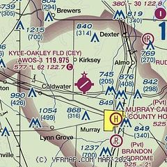
| Sectional chart |
|---|
|
| Airport distance calculator |
|---|
|
|
| Sunrise and sunset |
|---|
|
Times for 05-May-2026
| | Local
(UTC-5) | | Zulu
(UTC) |
|---|
| Morning civil twilight | | 05:28 | | 10:28 |
| Sunrise | | 05:56 | | 10:56 |
| Sunset | | 19:44 | | 00:44 |
| Evening civil twilight | | 20:12 | | 01:12 |
|
| Current date and time |
|---|
| Zulu (UTC) | 05-May-2026 22:07:47 |
|---|
| Local (UTC-5) | 05-May-2026 17:07:47 |
|---|
|
| METAR |
|---|
| KCEY | 052155Z AUTO 17008G16KT 140V210 1SM -DZ BR BKN007 OVC011 17/17 A2977 RMK AO2 P0014
|
KM25
12nm NW | 052155Z AUTO 20009G18KT 5SM -RA BR BKN004 OVC015 17/17 A2974 RMK AO2 CIG 003V006 P0000 T01740174
|
KPHT
20nm S | 052150Z AUTO 18009KT 1SM BR BKN007 BKN013 17/17 A2976 RMK A01
|
|
| TAF |
|---|
KPAH
31nm NW | 051730Z 0518/0618 18007KT P6SM -SHRA OVC012 TEMPO 0518/0521 4SM -SHRA BR BKN009 FM052100 20011KT P6SM -SHRA OVC012 PROB30 0521/0603 36008KT 3SM -TSRA OVC007CB FM060300 01009KT 5SM -SHRA BR OVC007 FM060900 02008KT P6SM OVC020 FM061400 02009KT P6SM BKN035
|
|
| NOTAMs |
|---|
NOTAMs are issued by the DoD/FAA and will open in a separate window not controlled by AirNav.
|
|

