FAA INFORMATION EFFECTIVE 09 JULY 2026
Location
| FAA Identifier: | M25 |
| Lat/Long: | 36-46-10.6650N 088-35-04.8050W
36-46.177750N 088-35.080083W
36.7696292,-88.5846681
(estimated) |
| Elevation: | 522.4 ft. / 159.2 m (surveyed) |
| Variation: | 02W (2015) |
| From city: | 3 miles NE of MAYFIELD, KY |
| Time zone: | UTC -5 (UTC -6 during Standard Time) |
| Zip code: | 42066 |
Airport Operations
| Airport use: | Open to the public |
| Activation date: | 12/1945 |
| Control tower: | no |
| ARTCC: | MEMPHIS CENTER |
| FSS: | LOUISVILLE FLIGHT SERVICE STATION |
| NOTAMs facility: | LOU (NOTAM-D service available) |
| Attendance: | 0700-1500 |
| Wind indicator: | lighted |
| Segmented circle: | yes |
| Lights: | REIL RWY 01 & 19; PAPI RWY 01 & 19; MIRL RWY 01/19 OPR DUSK-DAWN & ACTVT REIL RWY 01 & 19; PAPI RWY 01 & 19; MIRL RWY 01/19 CTAF. |
| Beacon: | white-green (lighted land airport)
Operates sunset to sunrise. |
Airport Communications
| CTAF/UNICOM: | 122.8 |
| WX AWOS-3: | 120.625 (270-247-2094) |
| WX AWOS-3 at CEY (12 nm SE): | 119.975 (270-489-2424) |
| WX ASOS at PAH (20 nm NW): | 118.375 (270-366-0642) |
- APCH/DEP SVC PRVDD BY MEMPHIS ARTCC ON FREQS 133.65/292.15 (PADUCAH RCAG).
Nearby radio navigation aids
| VOR radial/distance | | VOR name | | Freq | | Var |
|---|
| CNGr137/18.8 | | CUNNINGHAM VOR/DME | | 113.10 | | 03E |
Airport Services
| Fuel available: | 100LL JET-A+
100LL:AVBL H24 WITH CREDIT CARD. |
| Parking: | hangars and tiedowns |
| Airframe service: | MINOR |
| Powerplant service: | MAJOR |
| Bottled oxygen: | LOW |
Runway Information
Runway 1/19
| Dimensions: | 5002 x 100 ft. / 1525 x 30 m |
| Surface: | asphalt, in fair condition |
| Weight bearing capacity: | | PCN 6 /F/D/X/T | | Single wheel: | 16.5 |
|
| Runway edge lights: | medium intensity |
| RUNWAY 1 | | RUNWAY 19 |
| Latitude: | 36-45.766887N | | 36-46.588627N |
| Longitude: | 088-35.119982W | | 088-35.040193W |
| Elevation: | 519.2 ft. | | 522.3 ft. |
| Traffic pattern: | left | | left |
| Runway heading: | 006 magnetic, 004 true | | 186 magnetic, 184 true |
| Markings: | nonprecision, in good condition | | nonprecision, in good condition |
| Visual slope indicator: | 2-light PAPI on left (3.00 degrees glide path) | | 4-light PAPI on left (3.00 degrees glide path) |
| Runway end identifier lights: | yes | | yes |
| Touchdown point: | yes, no lights | | yes, no lights |
| Obstructions: | 31 ft. trees, 756 ft. from runway, 144 ft. left of centerline, 17:1 slope to clear | | 57 ft. tree, 1722 ft. from runway, 428 ft. right of centerline, 26:1 slope to clear |
Airport Ownership and Management from official FAA records
| Ownership: | Publicly-owned |
| Owner: | MAYFIELD & GRAVES COUNTY ARPT BOARD
227 AIRPORT ROAD
MAYFIELD, KY 42066
Phone (270) 970-2754
TODD MCBEE - 270-519-5586. |
| Manager: | BRENT ROBERTSON
227 AIRPORT ROAD
MAYFIELD, KY 42066
Phone 270-247-6878 |
Additional Remarks
| - | FOR CD CTC MEMPHIS ARTCC AT 901-368-8453/8449. |
Instrument Procedures
NOTE: All procedures below are presented as PDF files. If you need a reader for these files, you should download the free Adobe Reader.NOT FOR NAVIGATION. Please procure official charts for flight.
FAA instrument procedures published for use from 09 July 2026 at 0901Z to 06 August 2026 at 0900Z.
IAPs - Instrument Approach Procedures |
|---|
| RNAV (GPS) RWY 19 | |
download (244KB) |
| RNAV (GPS) Y RWY 01 | |
download (209KB) |
| RNAV (GPS) Z RWY 01 | |
download (202KB) |
| NOTE: Special Alternate Minimums apply | |
download (159KB) |
| NOTE: Special Take-Off Minimums/Departure Procedures apply | |
download (127KB) |
Other nearby airports with instrument procedures:
KCEY - Kyle-Oakley Field Airport (12 nm SE)
KPAH - Barkley Regional Airport (20 nm NW)
M34 - Kentucky Dam State Park Airport (20 nm NE)
1M7 - Fulton Airport (22 nm SW)
KPHT - Henry County Airport (28 nm S)
|
|

Road maps at:
MapQuest
Bing
Google
| Aerial photo |
|---|
WARNING: Photo may not be current or correct
 Photo by Rupert H. Holmes III
Photo taken 09-Sep-2017
looking northwest.
Photo by Rupert H. Holmes III
Photo taken 09-Sep-2017
looking northwest.
Do you have a better or more recent aerial photo of Mayfield Graves County Airport that you would like to share? If so, please send us your photo.
|
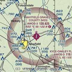
| Sectional chart |
|---|
|
| Airport distance calculator |
|---|
|
|
| Sunrise and sunset |
|---|
|
Times for 25-Jul-2026
| | Local
(UTC-5) | | Zulu
(UTC) |
|---|
| Morning civil twilight | | 05:26 | | 10:26 |
| Sunrise | | 05:55 | | 10:55 |
| Sunset | | 20:06 | | 01:06 |
| Evening civil twilight | | 20:35 | | 01:35 |
|
| Current date and time |
|---|
| Zulu (UTC) | 25-Jul-2026 23:09:04 |
|---|
| Local (UTC-5) | 25-Jul-2026 18:09:04 |
|---|
|
| METAR |
|---|
| KM25 | 252235Z AUTO VRB04KT 10SM SCT019 BKN026 OVC100 29/29 A2997 RMK AO2 T02870287
|
KCEY
12nm SE | 252255Z AUTO 15004KT 10SM SCT017 BKN110 28/27 A2999 RMK AO2
|
KPAH
20nm NW | 252253Z 00000KT 9SM FEW110 29/26 A2996 RMK AO2 SLP139 T02940256 $
|
|
| TAF |
|---|
KPAH
20nm NW | 251733Z 2518/2618 VRB04KT P6SM SCT015 OVC025 TEMPO 2518/2520 BKN015 FM260000 VRB02KT P6SM FEW100 FM260600 00000KT 4SM BR BKN150 FM261300 00000KT P6SM SCT200
|
|
| NOTAMs |
|---|
NOTAMs are issued by the DoD/FAA and will open in a separate window not controlled by AirNav.
|
|


