FAA INFORMATION EFFECTIVE 09 JULY 2026
Location
| FAA Identifier: | CFD |
| Lat/Long: | 30-42-56.5000N 096-19-52.9000W
30-42.941667N 096-19.881667W
30.7156944,-96.3313611
(estimated) |
| Elevation: | 366.7 ft. / 111.8 m (surveyed) |
| Variation: | 04E (2010) |
| From city: | 3 miles NE of BRYAN, TX |
| Time zone: | UTC -5 (UTC -6 during Standard Time) |
| Zip code: | 77808 |
Airport Operations
| Airport use: | Open to the public |
| Activation date: | 05/1942 |
| Control tower: | no |
| ARTCC: | HOUSTON CENTER |
| FSS: | MONTGOMERY COUNTY FLIGHT SERVICE STATION |
| NOTAMs facility: | CFD (NOTAM-D service available) |
| Attendance: | MON-FRI 0700-1800, ALL SAT-SUN 0900-1730 |
| Wind indicator: | lighted, UNLGTD SUPPLEMENTAL WINDSOCK 460 FT SW AER 15. |
| Segmented circle: | yes |
| Lights: | SR-SS MIRL RWY 15/33 PRESET LOW INTST; TO ACTVT OR INCR INTST - CTAF. |
| Beacon: | white-green (lighted land airport)
Operates sunset to sunrise. |
Airport Communications
| CTAF/UNICOM: | 123.0 |
| WX AWOS-3PT: | 125.975 (979-778-2544) |
| HOUSTON APPROACH: | 134.3 |
| HOUSTON DEPARTURE: | 134.3 |
| WX ASOS at CLL (8 nm S): | PHONE 979-846-1708 |
| WX AWOS-3PT at LHB (18 nm NW): | 118.675 (979-280-5596) |
Nearby radio navigation aids
| VOR radial/distance | | VOR name | | Freq | | Var |
|---|
| CLLr027/8.1 | | COLLEGE STATION VORTAC | | 113.30 | | 08E |
| TNVr323/29.3 | | NAVASOTA VOR/DME | | 115.90 | | 08E |
| LOAr209/30.8 | | LEONA VORTAC | | 110.80 | | 08E |
| NDB name | | Hdg/Dist | | Freq | | Var | | ID |
|---|
| ROWDY | | 358/13.3 | | 260 | | 03E | | CL | -.-. .-.. |
Airport Services
| Fuel available: | 100LL JET-A+ |
| Parking: | tiedowns |
| Airframe service: | MAJOR |
| Powerplant service: | MAJOR |
| Bulk oxygen: | NONE |
Runway Information
Runway 15/33
| Dimensions: | 4000 x 75 ft. / 1219 x 23 m |
| Surface: | asphalt, in fair condition |
| Runway edge lights: | medium intensity |
| RUNWAY 15 | | RUNWAY 33 |
| Latitude: | 30-43.231617N | | 30-42.650933N |
| Longitude: | 096-20.062367W | | 096-19.699633W |
| Elevation: | 357.2 ft. | | 366.7 ft. |
| Traffic pattern: | left | | left |
| Runway heading: | 148 magnetic, 152 true | | 328 magnetic, 332 true |
| Markings: | nonprecision, in fair condition | | nonprecision, in fair condition |
| Visual slope indicator: | 2-light PAPI on left (3.50 degrees glide path) | | 2-light PAPI on left (3.50 degrees glide path) |
| Runway end identifier lights: | yes | | yes |
| Touchdown point: | yes, no lights | | yes, no lights |
| Obstructions: | 27 ft. trees, lighted, 625 ft. from runway, 304 ft. left of centerline, 15:1 slope to clear | | 8 ft. road, 300 ft. from runway, 365 ft. right of centerline, 12:1 slope to clear |
Airport Ownership and Management from official FAA records
| Ownership: | Publicly-owned |
| Owner: | CITY OF BRYAN
P. O. BOX 1000
BRYAN, TX 77803
Phone 979-209-5233 |
| Manager: | BRANDON REID
6120 SH 21E
BRYAN, TX 77808
Phone 979-209-5233 |
Additional Remarks
| - | UNLGTD HNGRS 450 FT SW AER 15. |
| - | FOR CD CTC HOUSTON APCH AT 281-443-5844 TO CNL IFR CALL 281-443-5888. |
Instrument Procedures
NOTE: All procedures below are presented as PDF files. If you need a reader for these files, you should download the free Adobe Reader.NOT FOR NAVIGATION. Please procure official charts for flight.
FAA instrument procedures published for use from 09 July 2026 at 0901Z to 06 August 2026 at 0900Z.
IAPs - Instrument Approach Procedures |
|---|
| RNAV (GPS) RWY 15 | |
download (199KB) |
| RNAV (GPS) RWY 33 | |
download (187KB) |
| NOTE: Special Alternate Minimums apply | |
download (149KB) |
| NOTE: Special Take-Off Minimums/Departure Procedures apply | |
download (209KB) |
Other nearby airports with instrument procedures:
KCLL - Easterwood Field Airport (8 nm S)
KLHB - Hearne Municipal Airport (18 nm NW)
KRWV - Caldwell Municipal Airport (23 nm SW)
51R - Madisonville Municipal Airport (23 nm NE)
60R - Navasota Municipal Airport (24 nm SE)
|
|

Road maps at:
MapQuest
Bing
Google
| Aerial photo |
|---|
WARNING: Photo may not be current or correct
 Photo taken 14-Apr-2007
Do you have a better or more recent aerial photo of Coulter Field Airport that you would like to share? If so, please send us your photo.
|
| Sectional chart |
|---|
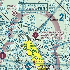
|
CAUTION: Diagram may not be current

| Airport distance calculator |
|---|
|
|
| Sunrise and sunset |
|---|
|
Times for 30-Jul-2026
| | Local
(UTC-5) | | Zulu
(UTC) |
|---|
| Morning civil twilight | | 06:16 | | 11:16 |
| Sunrise | | 06:43 | | 11:43 |
| Sunset | | 20:21 | | 01:21 |
| Evening civil twilight | | 20:47 | | 01:47 |
|
| Current date and time |
|---|
| Zulu (UTC) | 30-Jul-2026 10:12:47 |
|---|
| Local (UTC-5) | 30-Jul-2026 05:12:47 |
|---|
|
| METAR |
|---|
| KCFD | 300955Z AUTO 19005KT 10SM CLR 26/24 A2996 RMK AO2 T02550244 PWINO
|
KCLL
8nm S | 300953Z AUTO 19004KT 10SM CLR 25/24 A2994 RMK AO2 SLP133 T02500239
|
KLHB
18nm NW | 300955Z AUTO 14003KT 8SM BKN010 25/25 A2993 RMK AO2
|
|
| TAF |
|---|
KCLL
8nm S | 300524Z 3006/3106 19005KT P6SM SCT015 TEMPO 3013/3015 BKN015 FM301600 21010KT P6SM SCT030 FM301900 17010KT P6SM FEW250
|
|
| NOTAMs |
|---|
NOTAMs are issued by the DoD/FAA and will open in a separate window not controlled by AirNav.
|
|


