FAA INFORMATION EFFECTIVE 14 MAY 2026
Location
| FAA Identifier: | RWV |
| Lat/Long: | 30-30-55.7074N 096-42-14.7088W
30-30.928457N 096-42.245147W
30.5154743,-96.7040858
(estimated) |
| Elevation: | 390.6 ft. / 119.1 m (surveyed) |
| Variation: | 06E (1990) |
| From city: | 1 mile SW of CALDWELL, TX |
| Time zone: | UTC -5 (UTC -6 during Standard Time) |
| Zip code: | 77836 |
Airport Operations
| Airport use: | Open to the public |
| Activation date: | 05/1967 |
| Control tower: | no |
| ARTCC: | HOUSTON CENTER |
| FSS: | MONTGOMERY COUNTY FLIGHT SERVICE STATION |
| NOTAMs facility: | RWV (NOTAM-D service available) |
| Attendance: | UNATNDD |
| Wind indicator: | lighted |
| Segmented circle: | yes |
| Lights: | DUSK-DAWN, MIRL RWY 15/33 PRESET LOW INTST; TO INCR INTST AND ACTVT PAPI RWY 15 - CTAF. |
| Beacon: | white-green (lighted land airport)
Operates sunset to sunrise. |
Airport Communications
| CTAF: | 122.9 |
| WX AWOS-3PT: | 118.35 (979-567-6784) |
| HOUSTON APPROACH: | 134.3 |
| HOUSTON DEPARTURE: | 134.3 |
| WX ASOS at CLL (18 nm E): | PHONE 979-846-1708 |
Nearby radio navigation aids
| VOR radial/distance | | VOR name | | Freq | | Var |
|---|
| CLLr242/15.6 | | COLLEGE STATION VORTAC | | 113.30 | | 08E |
| TNVr284/36.1 | | NAVASOTA VOR/DME | | 115.90 | | 08E |
Airport Services
| Fuel available: | 100LL |
| Parking: | tiedowns |
| Airframe service: | NONE |
| Powerplant service: | NONE |
| Bottled oxygen: | NONE |
| Bulk oxygen: | NONE |
Runway Information
Runway 15/33
| Dimensions: | 3252 x 50 ft. / 991 x 15 m |
| Surface: | asphalt, in good condition |
| Weight bearing capacity: | |
| Runway edge lights: | medium intensity
PHOTOCELL SENSOR. |
| RUNWAY 15 | | RUNWAY 33 |
| Latitude: | 30-31.166067N | | 30-30.690843N |
| Longitude: | 096-42.388910W | | 096-42.101395W |
| Elevation: | 390.6 ft. | | 362.7 ft. |
| Traffic pattern: | left | | left |
| Runway heading: | 146 magnetic, 152 true | | 326 magnetic, 332 true |
| Displaced threshold: | no | | 242 ft. |
| Markings: | basic, in good condition | | basic, in good condition |
| Visual slope indicator: | 2-light PAPI on left (3.00 degrees glide path) | | |
| Touchdown point: | yes, no lights | | yes, no lights |
| Obstructions: | 35 ft. trees, 201 ft. from runway, 190 ft. left of centerline
30 FT TREES, 131-201 FT DSTC, 189-250 FT L. | | 50 ft. trees, 585 ft. from runway, 100 ft. left of centerline, 7:1 slope to clear
20 FT TREES, 120 FT DSTC, 200 FT L. |
Airport Ownership and Management from official FAA records
| Ownership: | Publicly-owned |
| Owner: | CITY OF CALDWELL
107 S HILL
CALDWELL, TX 77836
Phone 979-567-3271 |
| Manager: | THOMAS TRNKA
107 S HILL
CALDWELL, TX 77836
Phone 979-599-4639
EXT 102. MGR CELL 979-406-0465 |
Additional Remarks
| - | FOR CD CTC HOUSTON APCH AT 281-443-5844 TO CNL IFR CALL 281-443-5888. |
| - | RWY 15, 17 FT BLDG. PENETRATES TRSN SFC, 104 FT FM RWY END, 260 FT R. |
Instrument Procedures
NOTE: All procedures below are presented as PDF files. If you need a reader for these files, you should download the free Adobe Reader.NOT FOR NAVIGATION. Please procure official charts for flight.
FAA instrument procedures published for use from 14 May 2026 at 0901Z to 11 June 2026 at 0900Z.
IAPs - Instrument Approach Procedures |
|---|
| RNAV (GPS) RWY 15 | |
download (182KB) |
| RNAV (GPS) RWY 33 | |
download (188KB) |
| NOTE: Special Alternate Minimums apply **CHANGED** | |
download (149KB) |
| NOTE: Special Take-Off Minimums/Departure Procedures apply | |
download (70KB) |
Other nearby airports with instrument procedures:
KCLL - Easterwood Field Airport (18 nm E)
KLHB - Hearne Municipal Airport (22 nm N)
KCFD - Coulter Field Airport (23 nm NE)
11R - Brenham Municipal Airport (25 nm SE)
KGYB - Giddings-Lee County Airport (25 nm SW)
|
|

Road maps at:
MapQuest
Bing
Google
| Aerial photo |
|---|
WARNING: Photo may not be current or correct

Do you have a better or more recent aerial photo of Caldwell Municipal Airport that you would like to share? If so, please send us your photo.
|
| Sectional chart |
|---|
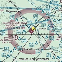
|
CAUTION: Diagram may not be current

| Airport distance calculator |
|---|
|
|
| Sunrise and sunset |
|---|
|
Times for 19-May-2026
| | Local
(UTC-5) | | Zulu
(UTC) |
|---|
| Morning civil twilight | | 06:04 | | 11:04 |
| Sunrise | | 06:31 | | 11:31 |
| Sunset | | 20:16 | | 01:16 |
| Evening civil twilight | | 20:42 | | 01:42 |
|
| Current date and time |
|---|
| Zulu (UTC) | 19-May-2026 06:03:37 |
|---|
| Local (UTC-5) | 19-May-2026 01:03:37 |
|---|
|
| METAR |
|---|
| KRWV | 190555Z AUTO 16014G21KT 10SM OVC015 26/23 A2992 RMK AO2 LTG DSNT SW
|
KCLL
18nm E | 190553Z AUTO 15015KT 10SM BKN015 OVC030 27/24 A2989 RMK AO2 SLP117 T02670239 10306 20261 403280250 56006
|
|
| TAF |
|---|
KCLL
18nm E | 182031Z 1821/1918 16017G26KT P6SM FEW040 FEW060 SCT070 FM190300 15012G18KT P6SM BKN015 BKN100 FM191600 15010G17KT P6SM BKN035
|
|
| NOTAMs |
|---|
NOTAMs are issued by the DoD/FAA and will open in a separate window not controlled by AirNav.
|
|


