FAA INFORMATION EFFECTIVE 09 JULY 2026
Location
| FAA Identifier: | CRS |
| Lat/Long: | 32-01-41.0000N 096-24-02.1000W
32-01.683333N 096-24.035000W
32.0280556,-96.4005833
(estimated) |
| Elevation: | 448.6 ft. / 136.7 m (surveyed) |
| Variation: | 06E (1990) |
| From city: | 5 miles SE of CORSICANA, TX |
| Time zone: | UTC -5 (UTC -6 during Standard Time) |
| Zip code: | 75110 |
Airport Operations
| Airport use: | Open to the public |
| Activation date: | 09/1941 |
| Control tower: | no |
| ARTCC: | FORT WORTH CENTER |
| FSS: | FORT WORTH FLIGHT SERVICE STATION |
| NOTAMs facility: | CRS (NOTAM-D service available) |
| Attendance: | MON-FRI 0830-1630, ALL SAT 0830-1530 |
| Wind indicator: | lighted |
| Segmented circle: | yes |
| Lights: | MIRL RWY 14/32 PRESET MED INTST; TO INCR INTST & ACTVT - CTAF. |
| Beacon: | white-green (lighted land airport)
Operates sunset to sunrise. |
Airport Communications
| CTAF/UNICOM: | 122.8 |
| WX ASOS: | 120.675 (903-872-9321) |
- APCH/DEP CTL SVC PRVDD BY FORT WORTH ARTCC (ZFW) ON FREQS 126.725/289.85 (CEDAR CREEK RCAG).
Nearby radio navigation aids
| VOR radial/distance | | VOR name | | Freq | | Var |
|---|
| CQYr218/13.2 | | CEDAR CREEK VORTAC | | 114.80 | | 06E |
| NDB name | | Hdg/Dist | | Freq | | Var | | ID |
|---|
| PYRAMID | | 308/14.3 | | 418 | | 06E | | PYF | .--. -.-- ..-. |
| CROSSROADS | | 263/22.6 | | 215 | | 02E | | CSZ | -.-. ... --.. |
Airport Services
| Fuel available: | 100LL JET-A MOGAS
100LL:100 LL AVBL SELF-SERVE ONLY. |
| Parking: | hangars and tiedowns |
| Airframe service: | NONE |
| Powerplant service: | NONE |
| Bulk oxygen: | NONE |
Runway Information
Runway 14/32
| Dimensions: | 5004 x 75 ft. / 1525 x 23 m |
| Surface: | asphalt, in good condition |
| Weight bearing capacity: | |
| Runway edge lights: | medium intensity |
| RUNWAY 14 | | RUNWAY 32 |
| Latitude: | 32-01.986727N | | 32-01.310093N |
| Longitude: | 096-24.159355W | | 096-23.604687W |
| Elevation: | 448.6 ft. | | 431.9 ft. |
| Traffic pattern: | left | | left |
| Runway heading: | 139 magnetic, 145 true | | 319 magnetic, 325 true |
| Markings: | nonprecision, in good condition | | nonprecision, in good condition |
| Visual slope indicator: | 4-box VASI on right (3.00 degrees glide path) | | 2-light PAPI on left (3.00 degrees glide path) |
| Runway end identifier lights: | yes | | yes |
| Touchdown point: | yes, no lights | | yes, no lights |
| Obstructions: | 17 ft. road, 480 ft. from runway, 280 ft. right of centerline, 16:1 slope to clear | | 50 ft. trees, 383 ft. from runway, 290 ft. right of centerline, 3:1 slope to clear |
Runway 2/20
| Dimensions: | 3200 x 75 ft. / 975 x 23 m |
| Surface: | turf, in fair condition |
| Runway edge markings: | RWY 2 & 20 ENDS MKD W/8 WHITE SQUARES. |
| RUNWAY 2 | | RUNWAY 20 |
| Latitude: | 32-01.494668N | | 32-01.984000N |
| Longitude: | 096-24.388898W | | 096-24.156833W |
| Elevation: | 438.0 ft. | | 448.0 ft. |
| Traffic pattern: | left | | left |
| Runway heading: | 016 magnetic, 022 true | | 196 magnetic, 202 true |
| Obstructions: | 45 ft. pline, marked, 930 ft. from runway, 225 ft. left and right of centerline, 20:1 slope to clear
40 FT MKD PLINE, 918 FT DSTC, 205 FT L, OBSTN CLNC SLOPE 16:1. | | 32 ft. tree, 674 ft. from runway, 170 ft. left of centerline, 21:1 slope to clear |
Airport Ownership and Management from official FAA records
| Ownership: | Publicly-owned |
| Owner: | CITY OF CORSICANA
200 N. 12TH
CORSICANA, TX 75110
Phone 903-654-4884 |
| Manager: | SAMUEL ZAMORA
9000 NAVARO DR.
CORSICANA, TX 75109
Phone 903-654-4857
ALSO 903-654-4878. 430-236-9042, AMGR CELL. |
Additional Remarks
| - | RWY 02, 45 FT MKD PLINE AT 935 FT ACRS EXTDD CNTRLN. |
| - | BIRDS & WILDLIFE ON & INVOF ARPT. |
| - | FOR CD CTC FORT WORTH ARTCC AT 817-858-7584. |
Instrument Procedures
NOTE: All procedures below are presented as PDF files. If you need a reader for these files, you should download the free Adobe Reader.NOT FOR NAVIGATION. Please procure official charts for flight.
FAA instrument procedures published for use from 09 July 2026 at 0901Z to 06 August 2026 at 0900Z.
IAPs - Instrument Approach Procedures |
|---|
| RNAV (GPS) RWY 14 | |
download (184KB) |
| RNAV (GPS) RWY 32 | |
download (177KB) |
| VOR/DME-A | |
download (199KB) |
| NOTE: Special Alternate Minimums apply | |
download (118KB) |
| NOTE: Special Take-Off Minimums/Departure Procedures apply | |
download (302KB) |
Other nearby airports with instrument procedures:
F41 - Ennis Municipal Airport (23 nm NW)
KLXY - Mexia-Limestone County Airport (24 nm S)
F44 - Athens Municipal Airport (30 nm E)
KINJ - Hillsboro Municipal Airport (36 nm W)
KJWY - Mid-Way Regional Airport (37 nm NW)
|
|

Road maps at:
MapQuest
Bing
Google
| Aerial photo |
|---|
WARNING: Photo may not be current or correct
 Photo by Dr. John H. Dorsett
Taken in November 2007
Photo by Dr. John H. Dorsett
Taken in November 2007
Do you have a better or more recent aerial photo of C David Campbell Field-Corsicana Municipal Airport that you would like to share? If so, please send us your photo.
|
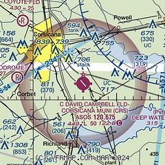
| Sectional chart |
|---|
|
| Airport distance calculator |
|---|
|
|
| Sunrise and sunset |
|---|
|
Times for 29-Jul-2026
| | Local
(UTC-5) | | Zulu
(UTC) |
|---|
| Morning civil twilight | | 06:13 | | 11:13 |
| Sunrise | | 06:40 | | 11:40 |
| Sunset | | 20:24 | | 01:24 |
| Evening civil twilight | | 20:51 | | 01:51 |
|
| Current date and time |
|---|
| Zulu (UTC) | 30-Jul-2026 03:46:41 |
|---|
| Local (UTC-5) | 29-Jul-2026 22:46:41 |
|---|
|
| METAR |
|---|
| KCRS | 300253Z AUTO 13004KT 10SM CLR 30/23 A2989 RMK AO2 SLP115 T03000228 53009
|
|
| TAF |
|---|
KACT
49nm SW | 292046Z 2921/3018 18010KT P6SM SCT040
|
|
| NOTAMs |
|---|
NOTAMs are issued by the DoD/FAA and will open in a separate window not controlled by AirNav.
|
|


