FAA INFORMATION EFFECTIVE 14 MAY 2026
Location
| FAA Identifier: | DEN |
| Lat/Long: | 39-51-42.0000N 104-40-23.4000W
39-51.700000N 104-40.390000W
39.8616667,-104.6731667
(estimated) |
| Elevation: | 5433.8 ft. / 1656.2 m (surveyed) |
| Variation: | 08E (2015) |
| From city: | 16 miles NE of DENVER, CO |
| Time zone: | UTC -6 (UTC -7 during Standard Time) |
| Zip code: | 80249 |
Airport Operations
| Airport use: | Open to the public |
| Activation date: | 08/1993 |
| Control tower: | yes |
| ARTCC: | DENVER CENTER |
| FSS: | DENVER FLIGHT SERVICE STATION |
| NOTAMs facility: | DEN (NOTAM-D service available) |
| Attendance: | CONTINUOUS |
| Wind indicator: | yes |
| Segmented circle: | no |
| Lights: | SS-SR |
| Beacon: | white-green (lighted land airport)
Operates sunset to sunrise. |
| Landing fee: | yes |
| Fire and rescue: | ARFF index E |
| International operations: | customs landing rights airport |
Airport Communications
| UNICOM: | 122.95 |
| WX ASOS: | PHONE 719-204-1223 |
| DENVER GROUND: | 121.35 ;WEST 121.85 ;EAST 377.1 ;EAST 379.175 ;WEST |
| DENVER TOWER: | 124.3 ;RWY 17R/35L 128.75 ;RWY 07/25 132.35 ;RWY 08/26, 17L/35R 135.3 ;RWY 16L/34R, 16R/34L 239.275 ;RWY 08/26, 17L/35R 273.55 ;RWY 07/25 322.45 ;RWY 17R/35L 351.95 ;RWY 16L/34R, 16R/34L |
| DENVER APPROACH: | 119.3 ;NORTH 120.35 ;SOUTH 124.95 ;NORTH 126.55 ;SOUTH |
| DENVER DEPARTURE: | 126.1 ;WEST 127.05 ;NORTH 128.25 ;EAST 128.45 ;SOUTH |
| CLEARANCE DELIVERY: | 118.75 |
| AALLE RNAV STAR: | 124.95 |
| CLASH STAR: | 126.55 |
| CLASS B: | 126.1 ;WEST 128.25 ;EAST 128.45 ;SOUTH 134.85 ;NORTH |
| D-ATIS: | 125.6 ;ARR 134.025 ;DEP 379.9 ;ARR |
| DANDD STAR: | 120.35 |
| EMERG: | 121.5 243.0 |
| FINAL CTL: | 120.8 |
| FLATI STAR: | 119.3 |
| IC: | 119.3 ;NORTH 120.35 ;SOUTH |
| LANDR STAR: | 124.95 |
| LARKS: | 120.35 |
| LAWGR STAR: | 124.95 |
| LONGZ STAR: | 119.3 |
| NIIXX STAR: | 126.55 |
| PINNR STAR: | 127.05 |
| POWDR STAR: | 120.35 |
| QUAIL STAR: | 120.35 |
| RAMMS STAR: | 120.35 |
| SSKII STAR: | 120.35 |
| TBARR STAR: | 120.35 |
| TOMSN STAR: | 119.3 |
| WX AWOS-3 at CFO (8 nm SE): | 119.025 (303-261-9104) |
| WX ASOS at APA (19 nm SW): | PHONE 720-873-2799 |
| WX AWOS-3PT at EIK (19 nm NW): | 133.825 (303-604-4339) |
- TA35 MINIMUM SAFE ALTITUDE WARNING (MSAW) ADVISORIES UNAVBL WITHIN 35 NM OF GRAND JUNCTION VORTAC BLO 14000 FT MSL.
- RY REDESIGNATION EFFECTIVE 28 NOV 02, CONSULT NOTAMS.
- ASDE-X IN USE. OPERATE TRANSPONDERS WITH ALTITUDE REPORTING MODE AND ADS-B (IF EQUIPPED) ENABLED ON ALL AIRPORT SURFACES.
Nearby radio navigation aids
| VOR radial/distance | | VOR name | | Freq | | Var |
|---|
| DVVr221/3.0 | | MILE HIGH VORTAC | | 114.70 | | 08E |
| DENr341/3.0 | | DENVER VOR/DME | | 117.90 | | 08E |
| FQFr336/10.6 | | FALCON VORTAC | | 116.30 | | 11E |
| BJCr087/21.7 | | JEFFCO VOR/DME | | 115.40 | | 11E |
| GLLr175/38.9 | | GILL VOR/DME | | 114.20 | | 13E |
Airport Services
| Fuel available: | 100LL JET-A |
| Parking: | hangars |
| Airframe service: | MAJOR |
| Powerplant service: | MAJOR |
| Bottled oxygen: | HIGH |
| Bulk oxygen: | HIGH |
Runway Information
Runway 16R/34L
| Dimensions: | 16000 x 200 ft. / 4877 x 61 m |
| Surface: | concrete/grooved, in good condition |
| Weight bearing capacity: | | Single wheel: | 116.0 | | Double wheel: | 240.0 | | Double tandem: | 515.0 | | Dual double tandem: | 1085.0 |
|
| Runway edge lights: | high intensity |
| RUNWAY 16R | | RUNWAY 34L |
| Latitude: | 39-53.747817N | | 39-51.113210N |
| Longitude: | 104-41.765010W | | 104-41.795277W |
| Elevation: | 5321.8 ft. | | 5327.0 ft. |
| Traffic pattern: | left | | left |
| Runway heading: | 173 magnetic, 181 true | | 353 magnetic, 001 true |
| Declared distances: | TORA:16000 TODA:16000 ASDA:16000 LDA:16000 | | TORA:16000 TODA:16000 ASDA:16000 LDA:16000 |
| Markings: | precision, in good condition | | precision, in good condition |
| Visual slope indicator: | 4-light PAPI on right (3.00 degrees glide path) | | 4-light PAPI on left (3.00 degrees glide path) |
| RVR equipment: | touchdown, midfield, rollout | | touchdown, midfield, rollout |
| Approach lights: | MALSR: 1,400 foot medium intensity approach lighting system with runway alignment indicator lights | | ALSF2: standard 2,400 foot high intensity approach lighting system with centerline sequenced flashers (category II or III) |
| Centerline lights: | yes | | yes |
| Touchdown point: | yes, lighted | | yes, lighted |
| Instrument approach: | ILS/DME | | ILS/DME |
Runway 7/25
| Dimensions: | 12000 x 150 ft. / 3658 x 46 m |
| Surface: | concrete/grooved, in good condition |
| Weight bearing capacity: | | Single wheel: | 116.0 | | Double wheel: | 240.0 | | Double tandem: | 515.0 | | Dual double tandem: | 1085.0 |
|
| Runway edge lights: | high intensity |
| RUNWAY 7 | | RUNWAY 25 |
| Latitude: | 39-50.456703N | | 39-50.439445N |
| Longitude: | 104-43.599383W | | 104-41.036187W |
| Elevation: | 5350.2 ft. | | 5355.0 ft. |
| Traffic pattern: | left | | left |
| Runway heading: | 082 magnetic, 090 true | | 263 magnetic, 271 true |
| Declared distances: | TORA:12000 TODA:12000 ASDA:12000 LDA:12000 | | TORA:12000 TODA:13000 ASDA:12000 LDA:12000 |
| Markings: | precision, in good condition | | precision, in good condition |
| Visual slope indicator: | 4-light PAPI on right (3.00 degrees glide path) | | 4-light PAPI on left (3.00 degrees glide path) |
| RVR equipment: | touchdown, rollout | | touchdown, rollout |
| Approach lights: | MALSR: 1,400 foot medium intensity approach lighting system with runway alignment indicator lights | | MALSR: 1,400 foot medium intensity approach lighting system with runway alignment indicator lights |
| Centerline lights: | yes | | yes |
| Touchdown point: | yes, lighted | | yes, no lights |
| Instrument approach: | ILS/DME | | ILS/DME |
| Obstructions: | none | | 117 ft. pole, 5100 ft. from runway, 500 ft. left of centerline, 41:1 slope to clear |
Runway 8/26
| Dimensions: | 12000 x 150 ft. / 3658 x 46 m |
| Surface: | concrete/grooved, in good condition |
| Weight bearing capacity: | | Single wheel: | 116.0 | | Double wheel: | 240.0 | | Double tandem: | 515.0 | | Dual double tandem: | 1085.0 |
|
| Runway edge lights: | high intensity |
| RUNWAY 8 | | RUNWAY 26 |
| Latitude: | 39-52.653348N | | 39-52.634615N |
| Longitude: | 104-39.733778W | | 104-37.169132W |
| Elevation: | 5354.3 ft. | | 5294.4 ft. |
| Traffic pattern: | left | | left |
| Runway heading: | 083 magnetic, 091 true | | 263 magnetic, 271 true |
| Declared distances: | TORA:12000 TODA:13000 ASDA:12000 LDA:12000 | | TORA:12000 TODA:12000 ASDA:12000 LDA:12000 |
| Markings: | precision, in good condition | | precision, in good condition |
| Visual slope indicator: | 4-light PAPI on left (3.00 degrees glide path) | | 4-light PAPI on left (3.00 degrees glide path) |
| RVR equipment: | touchdown, rollout | | touchdown, rollout |
| Approach lights: | MALSR: 1,400 foot medium intensity approach lighting system with runway alignment indicator lights | | MALSR: 1,400 foot medium intensity approach lighting system with runway alignment indicator lights |
| Centerline lights: | yes | | yes |
| Touchdown point: | yes, no lights | | yes, lighted |
| Instrument approach: | ILS/DME | | ILS/DME |
Runway 16L/34R
| Dimensions: | 12000 x 150 ft. / 3658 x 46 m |
| Surface: | concrete/grooved, in good condition |
| Weight bearing capacity: | | Single wheel: | 116.0 | | Double wheel: | 240.0 | | Double tandem: | 515.0 | | Dual double tandem: | 1085.0 |
|
| Runway edge lights: | high intensity |
| RUNWAY 16L | | RUNWAY 34R |
| Latitude: | 39-53.822168N | | 39-51.846238N |
| Longitude: | 104-41.208330W | | 104-41.231303W |
| Elevation: | 5349.9 ft. | | 5353.7 ft. |
| Traffic pattern: | left | | left |
| Runway heading: | 173 magnetic, 181 true | | 353 magnetic, 001 true |
| Declared distances: | TORA:12000 TODA:12000 ASDA:12000 LDA:12000 | | TORA:12000 TODA:13000 ASDA:12000 LDA:12000 |
| Markings: | precision, in good condition | | precision, in good condition |
| Visual slope indicator: | 4-light PAPI on left (3.00 degrees glide path) | | 4-light PAPI on left (3.00 degrees glide path) |
| RVR equipment: | touchdown, midfield, rollout | | touchdown, midfield, rollout |
| Approach lights: | MALSR: 1,400 foot medium intensity approach lighting system with runway alignment indicator lights | | ALSF2: standard 2,400 foot high intensity approach lighting system with centerline sequenced flashers (category II or III) |
| Centerline lights: | yes | | yes |
| Touchdown point: | yes, lighted | | yes, lighted |
| Instrument approach: | ILS/DME | | ILS/DME |
Runway 17L/35R
| Dimensions: | 12000 x 150 ft. / 3658 x 46 m |
| Surface: | concrete/grooved, in good condition |
| Weight bearing capacity: | | Single wheel: | 116.0 | | Double wheel: | 240.0 | | Double tandem: | 515.0 | | Dual double tandem: | 1085.0 |
|
| Runway edge lights: | high intensity |
| RUNWAY 17L | | RUNWAY 35R |
| Latitude: | 39-51.897145N | | 39-49.921178N |
| Longitude: | 104-38.478265W | | 104-38.502590W |
| Elevation: | 5328.1 ft. | | 5370.0 ft. |
| Traffic pattern: | left | | left |
| Runway heading: | 173 magnetic, 181 true | | 353 magnetic, 001 true |
| Declared distances: | TORA:12000 TODA:12000 ASDA:12000 LDA:12000 | | TORA:12000 TODA:12000 ASDA:12000 LDA:12000 |
| Markings: | precision, in good condition | | precision, in good condition |
| Visual slope indicator: | 4-light PAPI on left (3.00 degrees glide path) | | 4-light PAPI on right (3.00 degrees glide path) |
| RVR equipment: | touchdown, midfield, rollout | | touchdown, midfield, rollout |
| Approach lights: | MALSR: 1,400 foot medium intensity approach lighting system with runway alignment indicator lights | | ALSF2: standard 2,400 foot high intensity approach lighting system with centerline sequenced flashers (category II or III) |
| Centerline lights: | yes | | yes |
| Touchdown point: | yes, no lights | | yes, lighted |
| Instrument approach: | ILS/DME | | ILS/DME |
Runway 17R/35L
| Dimensions: | 12000 x 150 ft. / 3658 x 46 m |
| Surface: | concrete/grooved, in good condition |
| Weight bearing capacity: | | Single wheel: | 116.0 | | Double wheel: | 240.0 | | Double tandem: | 515.0 | | Dual double tandem: | 1085.0 |
|
| Runway edge lights: | high intensity |
| RUNWAY 17R | | RUNWAY 35L |
| Latitude: | 39-51.674702N | | 39-49.698770N |
| Longitude: | 104-39.609268W | | 104-39.633068W |
| Elevation: | 5377.9 ft. | | 5433.8 ft. |
| Traffic pattern: | left | | left |
| Runway heading: | 173 magnetic, 181 true | | 353 magnetic, 001 true |
| Declared distances: | TORA:12000 TODA:12000 ASDA:12000 LDA:12000 | | TORA:12000 TODA:12000 ASDA:12000 LDA:12000 |
| Markings: | precision, in good condition | | precision, in good condition |
| Visual slope indicator: | 4-light PAPI on left (3.00 degrees glide path) | | 4-light PAPI on right (3.00 degrees glide path) |
| RVR equipment: | touchdown, midfield, rollout | | touchdown, midfield, rollout |
| Approach lights: | MALSR: 1,400 foot medium intensity approach lighting system with runway alignment indicator lights | | ALSF2: standard 2,400 foot high intensity approach lighting system with centerline sequenced flashers (category II or III) |
| Centerline lights: | yes | | yes |
| Touchdown point: | yes, lighted | | yes, lighted |
| Instrument approach: | ILS/DME | | ILS/DME |
Airport Ownership and Management from official FAA records
| Ownership: | Publicly-owned |
| Owner: | CITY & COUNTY OF DENVER
DEPT OF AVIATION
DENVER, CO 80249
Phone 303-342-2200 |
| Manager: | PHIL WASHINGTON
ADMIN BLDG, 8500 PENA BLVD
DENVER, CO 80249
Phone (303) 342-2206 |
Additional Remarks
| A39-16L/34R | PCR VALUE: 1050/R/B/W/T |
| A39-16R/34L | PCR VALUE: 1050/R/B/W/T |
| A39-17L/35R | PCR VALUE: 1050/R/B/W/T |
| A39-07/25 | PCR VALUE: 1050/R/B/W/T |
| A39-17R/35L | PCR VALUE: 1050/R/B/W/T |
| A39-08/26 | PCR VALUE: 1050/R/B/W/T |
| - | DEP RWY 08, 25 & 34R HAS MNTND CWY 500 X 1000 FT 1.25 SLOPE. |
| - | TWY F7 CLSD TO ACFT WINGSPAN MORE THAN 118 FT. |
| - | OVHD PAX BRIDGE S SIDE OF CONCOURSE-A PRVDS 42 FT TAIL & 118 FT WINGSPAN CLNC WHEN ON TWY CNTRLN. |
| - | CUSTOMS AVBL PPR. |
| - | INFORMAL RWY USE PROGRAM IN EFCT H24; NOISE ABATEMENT INFO - ARPT MGMT 303-342-4200. |
| - | WATERFOWL & BIRDS INVOF ARPT. |
Instrument Procedures
NOTE: All procedures below are presented as PDF files. If you need a reader for these files, you should download the free Adobe Reader.NOT FOR NAVIGATION. Please procure official charts for flight.
FAA instrument procedures published for use from 14 May 2026 at 0901Z to 11 June 2026 at 0900Z.
STARs - Standard Terminal Arrivals |
|---|
| AALLE FOUR (RNAV) | |
2 pages:
[1] [2] (503KB) |
| AALLE FOUR (RNAV), CONT.2 | |
download (241KB) |
| CLASH FIVE (RNAV) | |
2 pages:
[1] [2] (444KB) |
| CLASH FIVE (RNAV), CONT.2 | |
download (330KB) |
| DANDD ONE | |
2 pages:
[1] [2] (325KB) |
| FLATI FIVE (RNAV) | |
2 pages:
[1] [2] (432KB) |
| FLATI FIVE (RNAV), CONT.2 | |
download (292KB) |
| LANDR THREE | |
2 pages:
[1] [2] (347KB) |
| LARKS THREE | |
2 pages:
[1] [2] (353KB) |
| LAWGR FOUR (RNAV) | |
2 pages:
[1] [2] (448KB) |
| LAWGR FOUR (RNAV), CONT.2 | |
download (261KB) |
| LONGZ FOUR (RNAV) | |
2 pages:
[1] [2] (477KB) |
| LONGZ FOUR (RNAV), CONT.2 | |
download (320KB) |
| NIIXX FOUR (RNAV) | |
2 pages:
[1] [2] (394KB) |
| NIIXX FOUR (RNAV), CONT.2 | |
download (259KB) |
| POWDR ONE | |
2 pages:
[1] [2] (326KB) |
| QUAIL ONE | |
download (250KB) |
| RAMMS EIGHT | |
2 pages:
[1] [2] (310KB) |
| SSKII FOUR (RNAV) | |
2 pages:
[1] [2] (494KB) |
| SSKII FOUR (RNAV), CONT.2 | |
download (271KB) |
| TBARR FOUR (RNAV) | |
2 pages:
[1] [2] (459KB) |
| TBARR FOUR (RNAV), CONT.2 | |
download (260KB) |
| TOMSN NINE | |
2 pages:
[1] [2] (339KB) |
IAPs - Instrument Approach Procedures |
|---|
| ILS OR LOC RWY 07 | |
download (320KB) |
| ILS OR LOC RWY 08 | |
download (299KB) |
| ILS OR LOC RWY 16L | |
download (311KB) |
| ILS OR LOC RWY 16R | |
download (331KB) |
| ILS OR LOC RWY 17L | |
download (340KB) |
| ILS OR LOC RWY 17R | |
download (330KB) |
| ILS OR LOC RWY 25 | |
download (284KB) |
| ILS OR LOC RWY 26 | |
download (289KB) |
| ILS OR LOC RWY 34L | |
download (343KB) |
| ILS OR LOC RWY 34R | |
download (334KB) |
| ILS OR LOC RWY 35L | |
download (327KB) |
| ILS OR LOC RWY 35R | |
download (345KB) |
| ILS RWY 34L (SA CAT I) | |
download (325KB) |
| ILS RWY 34R (SA CAT I) | |
download (315KB) |
| ILS RWY 35L (SA CAT I) | |
download (315KB) |
| ILS RWY 35R (SA CAT I) | |
download (327KB) |
| ILS RWY 34L (CAT II - III) | |
download (336KB) |
| ILS RWY 34R (CAT II - III) | |
download (327KB) |
| ILS RWY 35L (CAT II - III) | |
download (325KB) |
| ILS RWY 35R (CAT II - III) | |
download (338KB) |
| RNAV (RNP) Z RWY 07 | |
download (256KB) |
| RNAV (RNP) Z RWY 16L | |
download (232KB) |
| RNAV (RNP) Z RWY 16R | |
download (274KB) |
| RNAV (RNP) Z RWY 17L | |
download (249KB) |
| RNAV (RNP) Z RWY 17R | |
download (259KB) |
| RNAV (RNP) Z RWY 26 | |
download (245KB) |
| RNAV (RNP) Z RWY 34L | |
download (237KB) |
| RNAV (RNP) Z RWY 34R | |
download (268KB) |
| RNAV (RNP) Z RWY 35L | |
download (240KB) |
| RNAV (RNP) Z RWY 35R | |
download (245KB) |
| RNAV (GPS) Y RWY 07 | |
download (256KB) |
| RNAV (GPS) Y RWY 08 | |
download (254KB) |
| RNAV (GPS) Y RWY 16L | |
download (264KB) |
| RNAV (GPS) Y RWY 16R | |
download (306KB) |
| RNAV (GPS) Y RWY 17L | |
download (275KB) |
| RNAV (GPS) Y RWY 17R | |
download (267KB) |
| RNAV (GPS) Y RWY 25 | |
download (255KB) |
| RNAV (GPS) Y RWY 26 | |
download (258KB) |
| RNAV (GPS) Y RWY 34L | |
download (247KB) |
| RNAV (GPS) Y RWY 34R | |
download (267KB) |
| RNAV (GPS) Y RWY 35L | |
download (272KB) |
| RNAV (GPS) Y RWY 35R | |
download (260KB) |
Departure Procedures |
|---|
| BAYLR SIX (RNAV) | |
2 pages:
[1] [2] (523KB) |
| CHUWY ONE (RNAV) | |
2 pages:
[1] [2] (485KB) |
| CONNR EIGHT (RNAV) | |
2 pages:
[1] [2] (433KB) |
| COORZ SEVEN (RNAV) | |
2 pages:
[1] [2] (464KB) |
| DDRTH ONE (RNAV) | |
2 pages:
[1] [2] (523KB) |
| DENVER THREE | |
2 pages:
[1] [2] (263KB) |
| EEONS EIGHT (RNAV) | |
2 pages:
[1] [2] (544KB) |
| EMMYS EIGHT (RNAV) | |
2 pages:
[1] [2] (590KB) |
| EPKEE SEVEN (RNAV) | |
2 pages:
[1] [2] (472KB) |
| EXTAN SEVEN (RNAV) | |
2 pages:
[1] [2] (489KB) |
| HHOTH TWO (RNAV) | |
2 pages:
[1] [2] (535KB) |
| PIKES THREE | |
2 pages:
[1] [2] (296KB) |
| PLAINS TWO | |
2 pages:
[1] [2] (424KB) |
| ROCKIES SEVEN | |
2 pages:
[1] [2] (372KB) |
| SABTH TWO (RNAV) | |
2 pages:
[1] [2] (481KB) |
| SLEEK TWO (RNAV) | |
2 pages:
[1] [2] (457KB) |
| SMMUR TWO (RNAV) | |
2 pages:
[1] [2] (512KB) |
| SUDDZ ONE (RNAV) | |
2 pages:
[1] [2] (524KB) |
| XXWNG ONE (RNAV) | |
2 pages:
[1] [2] (514KB) |
| YELLOWSTONE FIVE | |
2 pages:
[1] [2] (374KB) |
| ZIMMR FOUR (RNAV) | |
2 pages:
[1] [2] (516KB) |
| NOTE: Special Take-Off Minimums/Departure Procedures apply | |
download (105KB) |
Other nearby airports with instrument procedures:
KCFO - Colorado Air and Space Port Airport (8 nm SE)
KBKF - Buckley Space Force Base (10 nm S)
KAPA - Centennial Airport (19 nm SW)
KEIK - Erie Municipal Airport (19 nm NW)
KBJC - Rocky Mountain Metro Airport (21 nm W)
|
|

Road maps at:
MapQuest
Bing
Google
| Aerial photo |
|---|
WARNING: Photo may not be current or correct
 Photo by Matt Beyer and Kyle Strunk
Taken in April 2020
looking south-southeast from an altitude of 10000ft.
Photo by Matt Beyer and Kyle Strunk
Taken in April 2020
looking south-southeast from an altitude of 10000ft.
Do you have a better or more recent aerial photo of Denver International Airport that you would like to share? If so, please send us your photo.
|
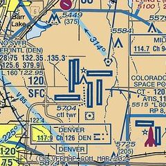
| Sectional chart |
|---|
|
 Download PDF
of official airport diagram from the FAA
| Airport distance calculator |
|---|
|
|
| Sunrise and sunset |
|---|
|
Times for 09-Jun-2026
| | Local
(UTC-6) | | Zulu
(UTC) |
|---|
| Morning civil twilight | | 04:58 | | 10:58 |
| Sunrise | | 05:31 | | 11:31 |
| Sunset | | 20:25 | | 02:25 |
| Evening civil twilight | | 20:57 | | 02:57 |
|
| Current date and time |
|---|
| Zulu (UTC) | 09-Jun-2026 18:16:13 |
|---|
| Local (UTC-6) | 09-Jun-2026 12:16:13 |
|---|
|
| METAR |
|---|
KDEN
2nm SE | 091753Z 33009KT 10SM FEW100 SCT160 BKN220 23/13 A2988 RMK AO2 SLP045 T02280128 10239 20133 56016
|
KCFO
8nm SE | 091547Z 15009KT 10SM CLR 26/09 A2994
|
KBKF
9nm S | 091758Z 33008KT 10SM FEW090 SCT150 BKN220 25/11 A2988 RMK AO2A SLP039 T02470109 10279 20133 57017
|
KEIK
19nm NW | 091755Z AUTO VRB06KT 9SM CLR 21/14 A2988 RMK AO2 T02120143 $
|
KAPA
19nm SW | 091753Z 00000KT 10SM FEW100 BKN150 BKN220 27/08 A2991 RMK AO2 SLP050 T02670083 10267 20139 58015
|
|
| TAF |
|---|
KDEN
2nm SE | 091738Z 0918/1024 33007KT P6SM FEW100 SCT150 BKN220 TEMPO 0918/0919 21020G30KT FM091900 22020G32KT P6SM VCSH SCT120 BKN150 TEMPO 0920/0924 23028G40KT FM100000 25017G26KT P6SM SCT120 BKN220 FM100300 29010KT P6SM SCT120 FM100600 02012KT P6SM FEW120 FM100900 15008KT P6SM FEW120 FM101800 28014G24KT P6SM FEW120
|
KBKF
9nm S | 091700Z 0917/1023 29010KT 9999 FEW090 SCT150 BKN220 QNH2989INS BECMG 0918/0919 22010G25KT 9999 VCSH SCT120 BKN150 QNH2981INS TEMPO 0920/0924 22020G35KT BECMG 1000/1001 24010G20KT 9999 NSW SCT120 BKN220 QNH2981INS BECMG 1002/1003 VRB06KT 9999 FEW140 FEW200 QNH2977INS TX31/0922Z TN15/1012Z
|
KAPA
19nm SW | 091738Z 0918/1018 VRB05KT P6SM FEW120 SCT150 BKN220 TEMPO 0918/0919 21022G31KT P6SM FEW120 SCT200 FM091900 22020G32KT P6SM VCSH SCT120 BKN150 TEMPO 0920/0924 23030G42KT FM100000 24017G26KT P6SM SCT120 BKN220 FM100300 22010KT P6SM SCT130 FM100800 VRB06KT P6SM FEW130 FM101300 17010KT P6SM FEW130 FM101700 28012G22KT P6SM FEW130
|
|
| NOTAMs |
|---|
NOTAMs are issued by the DoD/FAA and will open in a separate window not controlled by AirNav.
|
|


