FAA INFORMATION EFFECTIVE 11 JUNE 2026
Location
| FAA Identifier: | BJC |
| Lat/Long: | 39-54-31.7000N 105-07-01.9000W
39-54.528333N 105-07.031667W
39.9088056,-105.1171944
(estimated) |
| Elevation: | 5673.4 ft. / 1729.3 m (surveyed) |
| Variation: | 09E (2015) |
| From city: | 9 miles NW of DENVER, CO |
| Time zone: | UTC -6 (UTC -7 during Standard Time) |
| Zip code: | 80021 |
Airport Operations
| Airport use: | Open to the public |
| Activation date: | 10/1960 |
| Control tower: | yes |
| ARTCC: | DENVER CENTER |
| FSS: | DENVER FLIGHT SERVICE STATION |
| NOTAMs facility: | BJC (NOTAM-D service available) |
| Attendance: | CONTINUOUS |
| Wind indicator: | lighted |
| Segmented circle: | yes |
| Lights: | WHEN ATCT CLSD ACTVT MALSR RWY 30R; REIL RWY 12L, 12R & 30L; PAPI RWY 03, 12L, 12R, 21, 30L & 30R; MIRL RWY 03/21 & 12R/30L; HIRL RWY 12L/30R - CTAF. |
| Beacon: | white-green (lighted land airport)
Operates sunset to sunrise. |
| Fire and rescue: | ARFF index A |
| Airline operations: | 24 HR PPR FOR UNSKED ACR OPS WITH MORE THAN 30 PAX SEATS - 720-352-0395. |
| International operations: | US CUSTOMS USER FEE ARPT. |
Airport Communications
| CTAF: | 118.6 |
| ATIS: | 126.25 |
| WX AWOS-3: | PHONE 720-887-8067 |
| METRO GROUND: | 121.7 [0600-2200] |
| METRO TOWER: | 118.6 233.7 123.95 [0600-2200] |
| DENVER APPROACH: | 125.125 |
| DENVER DEPARTURE: | 125.125 |
| CLEARANCE DELIVERY: | 132.6 |
| BRNKO RNAV STAR: | 127.05 |
| DANDD STAR: | 120.35 |
| DUNNN RNAV STAR: | 128.45 |
| IC: | 233.7 |
| LARKS: | 120.35 |
| POWDR STAR: | 120.35 |
| QUAIL STAR: | 120.35 |
| RAMMS STAR: | 120.35 |
| TOMSN STAR: | 119.3 |
| WX AWOS-3PT at EIK (7 nm NE): | 133.825 (303-604-4339) |
| WX AWOS-3 at BDU (9 nm NW): | 118.825 (303-541-9540) |
| WX AWOS-3 at LMO (15 nm N): | 120.0 (303-684-7545) |
Nearby radio navigation aids
| VOR radial/distance | | VOR name | | Freq | | Var |
|---|
| BJCr093/1.0 | | JEFFCO VOR/DME | | 115.40 | | 11E |
| DENr277/21.8 | | DENVER VOR/DME | | 117.90 | | 08E |
| DVVr264/22.7 | | MILE HIGH VORTAC | | 114.70 | | 08E |
| FQFr289/26.4 | | FALCON VORTAC | | 116.30 | | 11E |
Airport Services
| Fuel available: | 100LL JET-A UL94
100LL:100LL SELF SVC. |
| Parking: | hangars and tiedowns |
| Airframe service: | MAJOR |
| Powerplant service: | MAJOR |
| Bottled oxygen: | HIGH/LOW |
| Bulk oxygen: | HIGH/LOW |
Runway Information
Runway 12L/30R
| Dimensions: | 9000 x 100 ft. / 2743 x 30 m |
| Surface: | asphalt/grooved, in good condition |
| Weight bearing capacity: | | Single wheel: | 65.0 | | Double wheel: | 105.0 | | Double tandem: | 150.0 |
|
| Runway edge lights: | high intensity |
| RUNWAY 12L | | RUNWAY 30R |
| Latitude: | 39-54.917572N | | 39-54.082433N |
| Longitude: | 105-07.704788W | | 105-06.115085W |
| Elevation: | 5660.5 ft. | | 5565.9 ft. |
| Traffic pattern: | left | | right |
| Runway heading: | 115 magnetic, 124 true | | 295 magnetic, 304 true |
| Declared distances: | TORA:9000 TODA:9000 ASDA:9000 LDA:9000 | | TORA:9000 TODA:9000 ASDA:9000 LDA:9000 |
| Markings: | precision, in fair condition | | precision, in fair condition |
| Visual slope indicator: | 4-light PAPI on left (3.00 degrees glide path) | | 4-light PAPI on left (3.00 degrees glide path) |
| Approach lights: | | | MALSR: 1,400 foot medium intensity approach lighting system with runway alignment indicator lights |
| Runway end identifier lights: | yes | | |
| Touchdown point: | yes, no lights | | yes, no lights |
| Instrument approach: | | | ILS |
Runway 12R/30L
| Dimensions: | 7002 x 75 ft. / 2134 x 23 m |
| Surface: | asphalt/grooved, in good condition |
| Weight bearing capacity: | | Single wheel: | 47.0 | | Double wheel: | 61.0 |
|
| Runway edge lights: | medium intensity |
| RUNWAY 12R | | RUNWAY 30L |
| Latitude: | 39-54.851695N | | 39-54.202043N |
| Longitude: | 105-07.892430W | | 105-06.655562W |
| Elevation: | 5673.3 ft. | | 5595.4 ft. |
| Traffic pattern: | right | | left |
| Runway heading: | 115 magnetic, 124 true | | 295 magnetic, 304 true |
| Declared distances: | TORA:7002 TODA:7002 ASDA:7002 LDA:7002 | | TORA:7002 TODA:7002 ASDA:7002 LDA:7002 |
| Markings: | nonprecision, in fair condition | | nonprecision, in fair condition |
| Visual slope indicator: | 2-light PAPI on left (3.00 degrees glide path) | | 2-light PAPI on left (3.00 degrees glide path) |
| Runway end identifier lights: | yes | | yes |
| Touchdown point: | yes, no lights | | yes, no lights |
Runway 3/21
| Dimensions: | 3600 x 75 ft. / 1097 x 23 m |
| Surface: | asphalt, in fair condition |
| Weight bearing capacity: | | Single wheel: | 40.0 | | Double wheel: | 45.0 | | Double tandem: | 65.0 |
|
| Runway edge lights: | medium intensity |
| RUNWAY 3 | | RUNWAY 21 |
| Latitude: | 39-54.352708N | | 39-54.842223N |
| Longitude: | 105-07.084615W | | 105-06.650683W |
| Elevation: | 5616.0 ft. | | 5600.0 ft. |
| Traffic pattern: | left | | right |
| Runway heading: | 025 magnetic, 034 true | | 205 magnetic, 214 true |
| Declared distances: | TORA:3600 TODA:3600 ASDA:3600 LDA:3600 | | TORA:3600 TODA:3600 ASDA:3600 LDA:3600 |
| Markings: | basic, in fair condition | | basic, in fair condition |
| Visual slope indicator: | 2-light PAPI on left (3.00 degrees glide path) | | 2-light PAPI on left (3.00 degrees glide path) |
| Touchdown point: | yes, no lights | | yes, no lights |
Airport Ownership and Management from official FAA records
| Ownership: | Publicly-owned |
| Owner: | JEFFERSON COUNTY
100 JEFFERSON CO PKWY
GOLDEN, CO 80419
Phone (303) 271-4850 |
| Manager: | ERICK DAHL
11755 AIRPORT WAY
BROOMFIELD, CO 80021
Phone (303) 271-4851 |
Additional Remarks
| A39-12L/30R | PCR VALUE: 360/F/D/X/T |
| A39-03/21 | PCR VALUE: 130/F/D/X/T |
| A39-12R/30L | PCR VALUE: 150/F/C/X/T |
| - | BIRDS & WILDLIFE ON & INVOF RWY. |
| - | TWY C1 & D MKD WITH REFLECTORS. |
| - | N TRML RAMP SLP EXCEEDS RCMDD STD. |
| - | HEL ARR/DEP FM RWY & TWYS. |
| - | ARFF INDEX B AVBL PPR - 720-352-0395 |
| - | PILOTS ARE REQUESTED TO AVOID FLIGHT DUE TO NESTING EAGLES: BLW 6500 FT MSL, BJC VOR 25 DEG RADIAL, 2.7 DME; OVER STANDLEY LAKE BLW 8000 FT MSL, BJC VOR 150 DEG RADIAL, 3.0 DME. |
| - | NOISE ABATEMENT PROC IN EFCT - 303-271-4850. |
| - | FLIGHT NOTIFICATION SERVICE (ADCUS) AVBL. |
Instrument Procedures
NOTE: All procedures below are presented as PDF files. If you need a reader for these files, you should download the free Adobe Reader.NOT FOR NAVIGATION. Please procure official charts for flight.
FAA instrument procedures published for use from 11 June 2026 at 0901Z to 09 July 2026 at 0900z.
STARs - Standard Terminal Arrivals |
|---|
| BRNKO FOUR (RNAV) **NEW** | |
2 pages:
[1] [2] (288KB) |
| BRNKO FOUR (RNAV), CONT.2 **NEW** | |
download (251KB) |
| DANDD ONE **NEW** | |
2 pages:
[1] [2] (323KB) |
| DUNNN SIX (RNAV) **NEW** | |
2 pages:
[1] [2] (311KB) |
| DUNNN SIX (RNAV), CONT.2 **NEW** | |
download (256KB) |
| LANDR THREE **NEW** | |
2 pages:
[1] [2] (345KB) |
| LARKS THREE **NEW** | |
2 pages:
[1] [2] (350KB) |
| PINNR THREE (RNAV) **NEW** | |
2 pages:
[1] [2] (363KB) |
| POWDR ONE **NEW** | |
2 pages:
[1] [2] (323KB) |
| QUAIL ONE **NEW** | |
download (249KB) |
| RAMMS EIGHT **NEW** | |
2 pages:
[1] [2] (307KB) |
| TOMSN NINE **NEW** | |
2 pages:
[1] [2] (337KB) |
IAPs - Instrument Approach Procedures |
|---|
| ILS OR LOC RWY 30R | |
download (457KB) |
| RNAV (GPS) RWY 12L | |
download (298KB) |
| RNAV (GPS) RWY 30L | |
download (306KB) |
| RNAV (GPS) RWY 30R | |
download (318KB) |
| VOR/DME RWY 30L/R | |
download (332KB) |
| RED ROCKS VISUAL RWY 12L/R | |
download (169KB) |
| NOTE: Special Alternate Minimums apply | |
download (139KB) |
Departure Procedures |
|---|
| DENVER THREE | |
2 pages:
[1] [2] (317KB) |
| ECHOO ONE (RNAV) | |
2 pages:
[1] [2] (288KB) |
| MRSHH TWO (RNAV) | |
2 pages:
[1] [2] (283KB) |
| PIKES THREE | |
2 pages:
[1] [2] (351KB) |
| PLAINS TWO | |
2 pages:
[1] [2] (482KB) |
| ROCKIES SEVEN | |
2 pages:
[1] [2] (430KB) |
| SKYEE ONE (RNAV) | |
2 pages:
[1] [2] (288KB) |
| WNGSS ONE (RNAV) | |
2 pages:
[1] [2] (331KB) |
| YELLOWSTONE FIVE | |
2 pages:
[1] [2] (432KB) |
| NOTE: Special Take-Off Minimums/Departure Procedures apply | |
download (288KB) |
Other nearby airports with instrument procedures:
KEIK - Erie Municipal Airport (7 nm NE)
KLMO - Vance Brand Airport (15 nm N)
KDEN - Denver International Airport (21 nm E)
KBKF - Buckley Space Force Base (21 nm SE)
KAPA - Centennial Airport (24 nm SE)
|
|

Road maps at:
MapQuest
Bing
Google
| Aerial photo |
|---|
WARNING: Photo may not be current or correct
 Photo by Mitch Bowers www.imagewerx.us
Taken in the Summer of 2016
looking east from 7000MSL.
Photo by Mitch Bowers www.imagewerx.us
Taken in the Summer of 2016
looking east from 7000MSL.
Do you have a better or more recent aerial photo of Rocky Mountain Metro Airport that you would like to share? If so, please send us your photo.
|
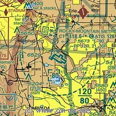
| Sectional chart |
|---|
|
CAUTION: Diagram may not be current
 Download PDF
of official airport diagram from the FAA
| Airport distance calculator |
|---|
|
|
| Sunrise and sunset |
|---|
|
Times for 06-Jul-2026
| | Local
(UTC-6) | | Zulu
(UTC) |
|---|
| Morning civil twilight | | 05:07 | | 11:07 |
| Sunrise | | 05:39 | | 11:39 |
| Sunset | | 20:31 | | 02:31 |
| Evening civil twilight | | 21:03 | | 03:03 |
|
| Current date and time |
|---|
| Zulu (UTC) | 06-Jul-2026 12:59:49 |
|---|
| Local (UTC-6) | 06-Jul-2026 06:59:49 |
|---|
|
| METAR |
|---|
| KBJC | 061247Z 00000KT 10SM CLR 19/09 A3017
|
KEIK
7nm NE | 061235Z AUTO 00000KT 4SM HZ FEW190 17/08 A3011 RMK AO2 T01660084 $
|
K1V5
9nm NW | AWOS 118.825 303-541-9540
No observation available
|
KBDU
9nm NW | 061235Z AUTO 16004KT 10SM CLR 18/03 A3013 RMK AO2
|
KLMO
15nm N | 061235Z AUTO 00000KT 7SM CLR 14/06 A3014 RMK AO2 T01410062
|
|
| TAF |
|---|
| KBJC | 061134Z 0612/0712 VRB06KT P6SM FU FEW150 FM061700 06007KT P6SM FEW120 FM062100 09012KT P6SM VCSH SCT120 BKN150 FM070100 17009KT P6SM FEW120 SCT150 FM070400 VRB06KT P6SM FEW130
|
|
| NOTAMs |
|---|
NOTAMs are issued by the DoD/FAA and will open in a separate window not controlled by AirNav.
|
|


