FAA INFORMATION EFFECTIVE 11 JUNE 2026
Location
| FAA Identifier: | CFO |
| Lat/Long: | 39-47-03.1000N 104-32-15.5000W
39-47.051667N 104-32.258333W
39.7841944,-104.5376389
(estimated) |
| Elevation: | 5515.2 ft. / 1681.0 m (surveyed) |
| Variation: | 08E (2015) |
| From city: | 19 miles E of DENVER, CO |
| Time zone: | UTC -6 (UTC -7 during Standard Time) |
| Zip code: | 80137 |
Airport Operations
| Airport use: | Open to the public |
| Activation date: | 09/1984 |
| Control tower: | yes |
| ARTCC: | DENVER CENTER |
| FSS: | DENVER FLIGHT SERVICE STATION |
| NOTAMs facility: | CFO (NOTAM-D service available) |
| Attendance: | 0700-2100
AFT HR SVC - AMGR. |
| Pattern altitude: | 6503.2 ft. MSL |
| Wind indicator: | lighted |
| Segmented circle: | yes |
| Lights: | ACTVT MALSR RWY 26 & 35; REIL RWY 08 & 17; PAPI RWY 08 & 26, 17 & 35; HIRL RWY 08/26; MIRL RWY 17/35 - CTAF. |
| Beacon: | white-green (lighted land airport)
Operates sunset to sunrise. |
Airport Communications
| CTAF: | 120.2 |
| UNICOM: | 122.95 |
| ATIS: | 119.025 |
| WX AWOS-3: | 119.025 (303-261-9104) |
| SPACE PORT GROUND: | 124.7 [0700-2100] |
| SPACE PORT TOWER: | 120.2 [0700-2100] |
| DENVER APPROACH: | 128.25 |
| DENVER DEPARTURE: | 128.25 |
| CLEARANCE DELIVERY: | 124.7 121.75 |
| DANDD STAR: | 120.35 |
| LARKS: | 120.35 |
| POWDR STAR: | 120.35 |
| QUAIL STAR: | 120.35 |
| RAMMS STAR: | 120.35 |
| TOMSN STAR: | 119.3 |
| ZOMBZ RNAV STAR: | 128.45 |
| WX ASOS at DEN (8 nm NW): | PHONE 719-204-1223 |
| WX ASOS at APA (19 nm SW): | PHONE 720-873-2799 |
Nearby radio navigation aids
| VOR radial/distance | | VOR name | | Freq | | Var |
|---|
| DENr099/5.9 | | DENVER VOR/DME | | 117.90 | | 08E |
| FQFr023/6.8 | | FALCON VORTAC | | 116.30 | | 11E |
| DVVr141/7.7 | | MILE HIGH VORTAC | | 114.70 | | 08E |
| BJCr095/28.8 | | JEFFCO VOR/DME | | 115.40 | | 11E |
Airport Services
| Fuel available: | 100LL JET-A
100LL:100LL SELF SVC AVBL H24 WITH CREDIT CARD. |
| Parking: | hangars and tiedowns |
| Airframe service: | MAJOR |
| Powerplant service: | MAJOR |
| Bottled oxygen: | NONE |
| Bulk oxygen: | HIGH/LOW |
Runway Information
Runway 8/26
| Dimensions: | 8002 x 100 ft. / 2439 x 30 m |
| Surface: | asphalt, in good condition |
| Weight bearing capacity: | | Single wheel: | 28.0 | | Double wheel: | 40.0 |
|
| Runway edge lights: | high intensity |
| RUNWAY 8 | | RUNWAY 26 |
| Latitude: | 39-47.640323N | | 39-47.613700N |
| Longitude: | 104-33.914677W | | 104-32.206948W |
| Elevation: | 5453.4 ft. | | 5489.1 ft. |
| Traffic pattern: | right | | left |
| Runway heading: | 083 magnetic, 091 true | | 263 magnetic, 271 true |
| Markings: | precision, in good condition | | precision, in good condition |
| Visual slope indicator: | 2-light PAPI on left (3.00 degrees glide path) | | 2-light PAPI on left (3.00 degrees glide path) |
| Approach lights: | | | MALSR: 1,400 foot medium intensity approach lighting system with runway alignment indicator lights |
| Runway end identifier lights: | yes | | |
| Touchdown point: | yes, no lights | | yes, no lights |
| Instrument approach: | | | ILS/DME |
Runway 17/35
| Dimensions: | 8000 x 100 ft. / 2438 x 30 m |
| Surface: | asphalt, in good condition |
| Weight bearing capacity: | | Single wheel: | 34.0 | | Double wheel: | 75.0 |
|
| Runway edge lights: | medium intensity |
| RUNWAY 17 | | RUNWAY 35 |
| Latitude: | 39-47.135743N | | 39-45.818397N |
| Longitude: | 104-31.454243W | | 104-31.453817W |
| Elevation: | 5476.5 ft. | | 5515.2 ft. |
| Traffic pattern: | left | | right |
| Runway heading: | 172 magnetic, 180 true | | 352 magnetic, 360 true |
| Markings: | precision, in fair condition | | precision, in fair condition |
| Visual slope indicator: | 4-light PAPI on left (3.00 degrees glide path) | | 4-light PAPI on left (3.00 degrees glide path) |
| Approach lights: | | | MALSR: 1,400 foot medium intensity approach lighting system with runway alignment indicator lights |
| Runway end identifier lights: | yes | | |
| Touchdown point: | yes, no lights | | yes, no lights |
| Instrument approach: | ILS/DME | | ILS/DME |
| Obstructions: | none | | 74 ft. pline, 3833 ft. from runway, 593 ft. right of centerline, 49:1 slope to clear |
Airport Ownership and Management from official FAA records
| Ownership: | Publicly-owned |
| Owner: | ADAMS COUNTY
4430 SOUTH ADAMS COUNTY PKWY
BRIGHTON, CO 80601
Phone (303) 659-2120 |
| Manager: | JEFF KLOSKA
5200 FRONT RANGE PKWY
WATKINS, CO 80137
Phone 303-261-9100 |
Additional Remarks
| - | TWY EDGE LIGHTS ALONG A, B, C, D, & E. |
| - | NOISE SENSITIVE AREAS SE, S & SW OF ARPT. AVOID FLT BLW 1000 FT OVR POPULATED AREAS. |
| - | CTN: USAF TRNG ACT INVOF COLORADO SPRINGS & PUEBLO ARPT. |
Instrument Procedures
NOTE: All procedures below are presented as PDF files. If you need a reader for these files, you should download the free Adobe Reader.NOT FOR NAVIGATION. Please procure official charts for flight.
FAA instrument procedures published for use from 11 June 2026 at 0901Z to 09 July 2026 at 0900z.
STARs - Standard Terminal Arrivals |
|---|
| DANDD ONE **NEW** | |
2 pages:
[1] [2] (323KB) |
| LANDR THREE **NEW** | |
2 pages:
[1] [2] (345KB) |
| LARKS THREE **NEW** | |
2 pages:
[1] [2] (350KB) |
| PINNR THREE (RNAV) **NEW** | |
2 pages:
[1] [2] (363KB) |
| POWDR ONE **NEW** | |
2 pages:
[1] [2] (323KB) |
| QUAIL ONE **NEW** | |
download (249KB) |
| RAMMS EIGHT **NEW** | |
2 pages:
[1] [2] (307KB) |
| TOMSN NINE **NEW** | |
2 pages:
[1] [2] (337KB) |
| ZOMBZ SIX (RNAV) **NEW** | |
2 pages:
[1] [2] (436KB) |
IAPs - Instrument Approach Procedures |
|---|
| ILS OR LOC RWY 17 | |
download (246KB) |
| ILS OR LOC RWY 26 | |
download (245KB) |
| ILS OR LOC RWY 35 | |
download (280KB) |
| RNAV (GPS) RWY 17 | |
download (228KB) |
| RNAV (GPS) RWY 26 | |
download (251KB) |
| RNAV (GPS) RWY 35 | |
download (240KB) |
| NOTE: Special Alternate Minimums apply | |
download (127KB) |
Departure Procedures |
|---|
| DENVER THREE | |
2 pages:
[1] [2] (273KB) |
| ECHOO ONE (RNAV) | |
2 pages:
[1] [2] (318KB) |
| MRSHH TWO (RNAV) | |
2 pages:
[1] [2] (312KB) |
| PIKES THREE | |
download (245KB) |
| PLAINS TWO | |
2 pages:
[1] [2] (439KB) |
| ROCKIES SEVEN | |
2 pages:
[1] [2] (388KB) |
| SKYEE ONE (RNAV) | |
2 pages:
[1] [2] (319KB) |
| WNGSS ONE (RNAV) | |
2 pages:
[1] [2] (363KB) |
| YELLOWSTONE FIVE | |
2 pages:
[1] [2] (388KB) |
| NOTE: Special Take-Off Minimums/Departure Procedures apply | |
download (292KB) |
Other nearby airports with instrument procedures:
KDEN - Denver International Airport (8 nm NW)
KBKF - Buckley Space Force Base (11 nm SW)
KAPA - Centennial Airport (19 nm SW)
KEIK - Erie Municipal Airport (27 nm NW)
KBJC - Rocky Mountain Metro Airport (28 nm W)
|
|

Road maps at:
MapQuest
Bing
Google
| Aerial photo |
|---|
WARNING: Photo may not be current or correct
 Photo taken 05-May-2005
Do you have a better or more recent aerial photo of Colorado Air and Space Port Airport that you would like to share? If so, please send us your photo.
|
| Sectional chart |
|---|
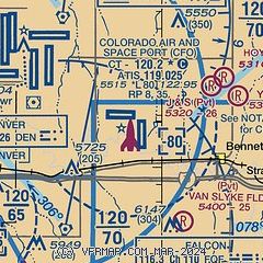
|
CAUTION: Diagram may not be current

| Airport distance calculator |
|---|
|
|
| Sunrise and sunset |
|---|
|
Times for 13-Jun-2026
| | Local
(UTC-6) | | Zulu
(UTC) |
|---|
| Morning civil twilight | | 04:58 | | 10:58 |
| Sunrise | | 05:30 | | 11:30 |
| Sunset | | 20:26 | | 02:26 |
| Evening civil twilight | | 20:59 | | 02:59 |
|
| Current date and time |
|---|
| Zulu (UTC) | 13-Jun-2026 17:13:13 |
|---|
| Local (UTC-6) | 13-Jun-2026 11:13:13 |
|---|
|
| METAR |
|---|
| KCFO | 131647Z 35008G17KT 10SM CLR 21/03 A3015
|
KDEN
6nm NW | 131653Z 03013G20KT 10SM FEW100 FEW180 21/05 A3013 RMK AO2 SLP131 T02060050 $
|
KBKF
11nm W | 131658Z 34008G17KT 10SM SCT220 20/05 A3013 RMK AO2A SLP134 T02000052
|
KAPA
19nm SW | 131653Z 36009G15KT 10SM FEW070 FEW140 FEW180 19/05 A3016 RMK AO2 SLP149 T01940050
|
|
| TAF |
|---|
KDEN
6nm NW | 131450Z 1315/1418 36010KT P6SM FEW150 FM131800 04010KT P6SM FEW250 FM132000 06012G21KT P6SM FEW080 SCT120 FM140100 04017G27KT P6SM VCSH FEW070 BKN100 FM140300 05013KT P6SM SCT030 BKN050 FM140600 06009KT P6SM FEW020 BKN030 FM140900 09010KT P6SM OVC020
|
KBKF
11nm W | 130920Z 1309/1415 VRB06KT 9999 SKC QNH2994INS BECMG 1301/1302 05015G29KT 9999 FEW110 BKN150 BKN210 QNH3011INS BECMG 1306/1307 VRB06KT 9999 NSW BKN055 OVC075 QNH3032INS TX29/1322Z TN13/1312Z
|
KAPA
19nm SW | 131123Z 1312/1412 29009KT P6SM SKC FM131300 35013KT P6SM FEW150 FM131600 02006KT P6SM FEW250 FM131800 05010KT P6SM SCT100 FM132300 06015G24KT P6SM VCSH FEW080 BKN100 FM140400 03009KT P6SM FEW020 BKN050 FM140700 06009KT P6SM OVC030
|
|
| NOTAMs |
|---|
NOTAMs are issued by the DoD/FAA and will open in a separate window not controlled by AirNav.
|
|


