FAA INFORMATION EFFECTIVE 25 DECEMBER 2025
Location
| FAA Identifier: | DLZ |
| Lat/Long: | 40-16-46.3517N 083-06-48.1810W
40-16.772528N 083-06.803017W
40.2795421,-83.1133836
(estimated) |
| Elevation: | 945.1 ft. / 288.1 m (surveyed) |
| Variation: | 06W (2000) |
| From city: | 3 miles SW of DELAWARE, OH |
| Time zone: | UTC -5 (UTC -4 during Daylight Saving Time) |
| Zip code: | 43015 |
Airport Operations
| Airport use: | Open to the public |
| Activation date: | 08/1945 |
| Control tower: | no |
| ARTCC: | INDIANAPOLIS CENTER |
| FSS: | DAYTON FLIGHT SERVICE STATION |
| NOTAMs facility: | DLZ (NOTAM-D service available) |
| Attendance: | 0800-1700
CLSD THANKSGIVING, CHRISTMAS, & NEW YEARS. |
| Wind indicator: | lighted |
| Segmented circle: | no |
| Lights: | ACTVT REIL RWY 10 & 28; PAPI RWY 10 & 28; MIRL RWY 10/28 - CTAF. |
| Beacon: | white-green (lighted land airport)
Operates sunset to sunrise. |
Airport Communications
| CTAF/UNICOM: | 122.7 |
| WX AWOS-3: | 119.025 (740-203-1878) |
| COLUMBUS APPROACH: | 125.95 |
| COLUMBUS DEPARTURE: | 125.95 |
| IC: | 125.95 |
| WX AWOS-3 at MRT (11 nm W): | 119.275 (937-644-2967) |
| WX ASOS at OSU (12 nm S): | 121.35 (614-451-2465) |
| WX AWOS-3PT at 4I9 (19 nm NE): | 121.4 (419-947-1039) |
| WX ASOS at CMH (20 nm SE): | 124.6 (614-333-9354) |
Nearby radio navigation aids
| VOR radial/distance | | VOR name | | Freq | | Var |
|---|
| BUDr191/(20.3) | | BUCKEYE VOR | | 109.80 | | 05W |
| APEr294/25.3 | | APPLETON VORTAC | | 116.70 | | 06W |
| NDB name | | Hdg/Dist | | Freq | | Var | | ID |
|---|
| FULER | | 022/13.0 | | 515 | | 05W | | OS | --- ... |
Airport Services
| Fuel available: | 100LL JET-A JET-A+ |
| Parking: | hangars and tiedowns |
| Airframe service: | MAJOR |
| Powerplant service: | MAJOR |
| Bottled oxygen: | LOW |
| Bulk oxygen: | NONE |
Runway Information
Runway 10/28
| Dimensions: | 5800 x 100 ft. / 1768 x 30 m |
| Surface: | asphalt/grooved, in good condition |
| Weight bearing capacity: | | PCN 39 /F/C/X/T | | Single wheel: | 100.0 | | Double wheel: | 139.0 | | Double tandem: | 233.0 |
|
| Runway edge lights: | medium intensity |
| RUNWAY 10 | | RUNWAY 28 |
| Latitude: | 40-16.841792N | | 40-16.703265N |
| Longitude: | 083-07.420020W | | 083-06.186012W |
| Elevation: | 944.2 ft. | | 944.7 ft. |
| Traffic pattern: | left | | left |
| Runway heading: | 104 magnetic, 098 true | | 284 magnetic, 278 true |
| Markings: | nonprecision, in good condition | | nonprecision, in good condition |
| Visual slope indicator: | 4-light PAPI on left (3.00 degrees glide path) | | 4-light PAPI on left (3.00 degrees glide path)
PAPI UNUSBL BYD 8 DEGS RIGHT OF CNTRLN. |
| Runway end identifier lights: | yes | | yes |
| Touchdown point: | yes, no lights | | yes, no lights |
| Obstructions: | 144 ft. hill, 3061 ft. from runway, 314 ft. right of centerline, 19:1 slope to clear | | 75 ft. trees, 1476 ft. from runway, 230 ft. left of centerline, 17:1 slope to clear |
Airport Ownership and Management from official FAA records
| Ownership: | Publicly-owned |
| Owner: | CITY OF DELAWARE
1 S SANDUSKY ST
DELAWARE, OH 43015-2326
Phone 740-203-1800 |
| Manager: | KEVIN PIATT
1075 PITTSBURGH DR
DELAWARE, OH 43015-3848
Phone 740-203-1870
AFT HRS 740-203-1870, OPTION 9. |
Additional Remarks
| A30A-28 | CALM WIND RWY. |
| - | OCNL DEER & OTR WILDLIFE ON & INVOF ARPT. |
| - | INTMT NGT ACT AT QUARRY OFF WEST END OF RWY 10. |
| - | ULTRALIGHT TFC RMN S OF RWY AT 400 FT AGL. |
| - | FOR CD CTC COLUMBUS APCH AT 614-338-8537. |
Instrument Procedures
NOTE: All procedures below are presented as PDF files. If you need a reader for these files, you should download the free Adobe Reader.NOT FOR NAVIGATION. Please procure official charts for flight.
FAA instrument procedures published for use from 25 December 2025 at 0901z to 22 January 2026 at 0900z.
IAPs - Instrument Approach Procedures |
|---|
| RNAV (GPS) RWY 10 | |
download (202KB) |
| RNAV (GPS) RWY 28 | |
download (210KB) |
| VOR RWY 28 | |
download (189KB) |
| NOTE: Special Take-Off Minimums/Departure Procedures apply | |
download (487KB) |
Other nearby airports with instrument procedures:
KMRT - Union County Airport (11 nm W)
KOSU - Ohio State University Airport (12 nm S)
4I9 - Morrow County Airport (19 nm NE)
KCMH - John Glenn Columbus International Airport (20 nm SE)
KMNN - Marion Municipal Airport (20 nm N)
|
|

Road maps at:
MapQuest
Bing
Google
| Aerial photo |
|---|
WARNING: Photo may not be current or correct
 Photo by Don Piatt
Taken in August 2006
Photo by Don Piatt
Taken in August 2006
Do you have a better or more recent aerial photo of Delaware Municipal Airport - Jim Moore Field that you would like to share? If so, please send us your photo.
|
| Sectional chart |
|---|
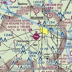
|
| Airport distance calculator |
|---|
|
|
| Sunrise and sunset |
|---|
|
Times for 10-Jan-2026
| | Local
(UTC-5) | | Zulu
(UTC) |
|---|
| Morning civil twilight | | 07:26 | | 12:26 |
| Sunrise | | 07:56 | | 12:56 |
| Sunset | | 17:24 | | 22:24 |
| Evening civil twilight | | 17:54 | | 22:54 |
|
| Current date and time |
|---|
| Zulu (UTC) | 10-Jan-2026 08:08:03 |
|---|
| Local (UTC-5) | 10-Jan-2026 03:08:03 |
|---|
|
| METAR |
|---|
| KDLZ | 100755Z AUTO 08005KT 10SM CLR 04/03 A3014 RMK AO2
|
KMRT
11nm W | 100755Z AUTO 07005KT 10SM SCT023 04/02 A3015 RMK AO2 T00370015
|
KOSU
12nm S | 100753Z AUTO 06005KT 10SM CLR 03/01 A3014 RMK AO2 SLP210 T00330011 $
|
KCMH
20nm SE | 100751Z 04003KT 10SM OVC150 03/01 A3014 RMK AO2 SLP208 T00330011
|
|
| TAF |
|---|
KCMH
20nm SE | 100520Z 1006/1106 03005KT P6SM BKN200 FM100900 09006KT P6SM BKN035 FM101500 16006KT 5SM -SHRA OVC022 FM101700 19008KT 4SM -RA OVC006 FM102000 26010KT 3SM -RA OVC006 FM110000 27012G20KT P6SM OVC012 FM110400 26010KT P6SM BKN022
|
|
| NOTAMs |
|---|
NOTAMs are issued by the DoD/FAA and will open in a separate window not controlled by AirNav.
|
|


