FAA INFORMATION EFFECTIVE 16 APRIL 2026
Location
| FAA Identifier: | CMH |
| Lat/Long: | 39-59-49.0080N 082-53-31.7730W
39-59.816800N 082-53.529550W
39.9969467,-82.8921592
(estimated) |
| Elevation: | 815 ft. / 248.4 m (surveyed) |
| Variation: | 07W (2015) |
| From city: | 6 miles E of COLUMBUS, OH |
| Time zone: | UTC -4 (UTC -5 during Standard Time) |
| Zip code: | 43219 |
Airport Operations
| Airport use: | Open to the public |
| Activation date: | 10/1937 |
| Control tower: | yes |
| ARTCC: | INDIANAPOLIS CENTER |
| FSS: | DAYTON FLIGHT SERVICE STATION |
| NOTAMs facility: | CMH (NOTAM-D service available) |
| Attendance: | CONTINUOUS |
| Wind indicator: | yes |
| Segmented circle: | no |
| Beacon: | white-green (lighted land airport)
Operates sunset to sunrise. |
| Landing fee: | yes |
| Fire and rescue: | ARFF index C |
| International operations: | customs landing rights airport
TO REQUEST LANDING RIGHTS CTC US CUSTOMS BTN 0730-2200
MON-FRI AT 614-497-1865. |
Airport Communications
| UNICOM: | 122.95 |
| WX ASOS: | 124.6 (614-333-9354) |
| COLUMBUS GROUND: | 121.9 348.6 |
| COLUMBUS TOWER: | 132.7 257.8 |
| COLUMBUS APPROACH: | 125.95 ;280-099 134.0 ;100-279 279.6 ;100-279 317.775 ;280-099 371.975 ;280-099 |
| COLUMBUS DEPARTURE: | 125.95 ;280-099 134.0 ;100-279 279.6 ;100-279 317.775 ;280-099 371.975 ;280-099 |
| CLEARANCE DELIVERY: | 126.3 |
| CBUSS STAR: | 125.95 371.975 |
| CLASS C: | 125.95 ;280-099 134.0 ;100-279 279.6 ;100-279 317.775 ;280-099 |
| CLPRR STAR: | 134.0 |
| D-ATIS: | 124.6 |
| DUBLN STAR: | 125.95 371.975 |
| EMERG: | 121.5 243.0 |
| IC: | 125.95 ;280-099 371.975 ;280-099 |
| JAKTZ STAR: | 134.0 |
| OPS: | 122.775 ;DEICE PAD CONTROL |
| SCRLT STAR: | 134.0 |
| WX ASOS at OSU (10 nm NW): | 121.35 (614-451-2465) |
| WX AWOS-3 at LCK (11 nm S): | PHONE 614-492-2441 |
| WX AWOS-3PT at TZR (13 nm SW): | 135.925 (614-878-1722) |
| WX ASOS at LHQ (18 nm SE): | 118.375 (740-681-1097) |
| WX AWOS-3PT at DLZ (20 nm NW): | 119.025 (740-203-1878) |
| WX ASOS at VTA (20 nm E): | 121.125 (740-522-1066) |
- SAID IN USE. OPERATE TRANSPONDERS WITH ALTITUDE REPORTING MODE AND ADS-B (IF EQUIPPED) ENABLED ON ALL AIRPORT SURFACES.
Nearby radio navigation aids
| VOR radial/distance | | VOR name | | Freq | | Var |
|---|
| APEr242/16.7 | | APPLETON VORTAC | | 116.70 | | 06W |
| XUBr013/(28.5) | | YELLOW BUD VOR | | 112.50 | | 05W |
| BUDr173/(38.0) | | BUCKEYE VOR | | 109.80 | | 05W |
| NDB name | | Hdg/Dist | | Freq | | Var | | ID |
|---|
| PICKL | | 347/7.4 | | 376 | | 07W | | LC | .-.. -.-. |
| FULER | | 113/14.8 | | 515 | | 05W | | OS | --- ... |
| COURT HOUSE | | 050/33.1 | | 414 | | 06W | | CSS | -.-. ... ... |
Airport Services
| Fuel available: | 100 JET-A1+ |
| Parking: | hangars and tiedowns |
| Airframe service: | MAJOR |
| Powerplant service: | MAJOR |
| Bottled oxygen: | HIGH/LOW |
| Bulk oxygen: | NONE |
Runway Information
Runway 10R/28L
| Dimensions: | 10114 x 150 ft. / 3083 x 46 m |
| Surface: | asphalt/grooved, in good condition |
| Weight bearing capacity: | | Single wheel: | 120.0 | | Double wheel: | 250.0 | | Double tandem: | 550.0 | | Dual double tandem: | 1120.0 |
|
| Runway edge lights: | high intensity |
| RUNWAY 10R | | RUNWAY 28L |
| Latitude: | 39-59.619088N | | 39-59.496837N |
| Longitude: | 082-54.550703W | | 082-52.390905W |
| Elevation: | 804.9 ft. | | 815.0 ft. |
| Traffic pattern: | left | | left |
| Runway heading: | 101 magnetic, 094 true | | 281 magnetic, 274 true |
| Declared distances: | TORA:10114 TODA:10114 ASDA:10114 LDA:10114 | | TORA:10114 TODA:10114 ASDA:10114 LDA:10114 |
| Markings: | precision, in good condition | | precision, in good condition |
| Visual slope indicator: | 4-light PAPI on left (3.00 degrees glide path) | | 4-light PAPI on left (3.00 degrees glide path) |
| RVR equipment: | touchdown, rollout | | touchdown, rollout |
| Approach lights: | MALSR: 1,400 foot medium intensity approach lighting system with runway alignment indicator lights | | MALSR: 1,400 foot medium intensity approach lighting system with runway alignment indicator lights |
| Runway end identifier lights: | no | | no |
| Centerline lights: | yes | | yes |
| Touchdown point: | yes, lighted | | yes, lighted |
| Instrument approach: | ILS/DME | | ILS/DME |
Runway 10L/28R
| Dimensions: | 8000 x 150 ft. / 2438 x 46 m |
| Surface: | asphalt/grooved, in good condition |
| Weight bearing capacity: | | Single wheel: | 120.0 | | Double wheel: | 242.0 | | Double tandem: | 472.0 | | Dual double tandem: | 965.0 |
|
| Runway edge lights: | high intensity |
| RUNWAY 10L | | RUNWAY 28R |
| Latitude: | 40-00.192178N | | 40-00.095513N |
| Longitude: | 082-54.458235W | | 082-52.749487W |
| Elevation: | 814.7 ft. | | 812.3 ft. |
| Traffic pattern: | left | | left |
| Runway heading: | 101 magnetic, 094 true | | 281 magnetic, 274 true |
| Declared distances: | TORA:8000 TODA:8000 ASDA:8000 LDA:8000 | | TORA:8000 TODA:8000 ASDA:8000 LDA:8000 |
| Markings: | precision, in good condition | | precision, in good condition |
| Visual slope indicator: | 4-light PAPI on left (3.00 degrees glide path) | | 4-light PAPI on right (3.00 degrees glide path) |
| RVR equipment: | touchdown, rollout | | touchdown, rollout |
| Approach lights: | MALSR: 1,400 foot medium intensity approach lighting system with runway alignment indicator lights | | MALSR: 1,400 foot medium intensity approach lighting system with runway alignment indicator lights |
| Runway end identifier lights: | | | no |
| Touchdown point: | yes, no lights | | yes, no lights |
| Instrument approach: | ILS/DME | | ILS/DME |
Airport Ownership and Management from official FAA records
| Ownership: | Publicly-owned |
| Owner: | COLUMBUS REGIONAL AIRPORT AUTH
4600 INTERNATIONAL GATEWAY
COLUMBUS, OH 43219
Phone 614-239-4000 |
| Manager: | DAREN A GRIFFIN
COLUMBUS REGIONAL AIRPORT AUTHORITY, 4600 INTERNATIONAL GATEWAY
COLUMBUS, OH 43219
Phone 614-239-4004 |
Additional Remarks
| A39-10L/28R | PCR VALUE: 557/F/A/X/T |
| A39-10R/28L | PCR VALUE: 778/F/A/X/T |
| A30A-28R | RWY 28R BLAST PAD 200 FT X 200 FT. |
| A30A-10L | RWY 10L BLAST PAD 200 FT X 200 FT. |
| - | MODEL ACFT TFC WITHIN A 1 NM RDS OF A POINT 8 NM ON A 010 DEG BRG FM THE ARPT; SFC - 5000 FT AGL; SR-SS DLY. |
| - | ALL SURFACES AROUND TERMINAL; NORTH OF TWY 'D' & SOUTH OF TWY 'E' ARE NON-MOVEMENT AREAS. |
| - | NOISE BARRIER LOCATED AT SE SIDE OF AIRFIELD RESTRICTED TO ACFT WITH WINGSPAN LESS THAN 79 FT. |
| - | TO REQ LDG RIGHTS CTC US CUSTOMS BETWEEN 1230-0300Z, MON-FRI AT 614-497-1865. |
| - | FLIGHT NOTIFICATION SERVICE (ADCUS) AVBL. |
| - | TWY F1 RSTRD TO AIRCRAFT WITH WINGSPAN LESS THAN 120 FT. |
| - | BIRDS INVOF ARPT. |
| - | TWYS R2, R3, R4, R5 AND R6 RSTRD TO WINGSPAN LESS THAN 118 FT. |
| - | TWY R1 RSTRD TO ACFT WITH WINGSPAN LESS THAN 79 FT. |
| - | TAXILANE CONCOURSE A BTN TWY D3 AND TWY D4 CLSD TO ACFT WINGSPAN MORE THAN 130 FT. |
| - | TAXILANE CONCOURSE C BTN TWY J AND TWY K CLSD TO ACFT WINGSPAN MORE THAN 135 FT. |
| - | HOLD PAD FOR RWY 28L RSTRD TO ACFT WITH WINGSPAN LESS THAN 118 FT. |
| - | PILOTS CONDUCTING EFVS OPS; BE AWARE LED ALS IN USE RWY 28L. |
| - | TWY D-5 PAVEMENT (NORTH OF TWY D) IS RSTRD TO ACFT WITH WINGSPAN LESS THAN 79 FT. |
| - | BE ALERT: RY 10L/28R RESTRICTIONS ON STAGE I & II TURBOJET ACFT 2200-0800 & ON STAGE III TURBOJET ACFT 2200-0700. PRACTICE APCHS FOR HIGH NOISE LEVEL TYPE ACFT INCLUDING NON-STAGE III MIL JET ACFT SHALL NOT BE APPROVED UNLESS RY 10R/28L IS IN USE & THE APCH TERMINATES IN A FULL STOP TAXI-BACK OPN. |
Instrument Procedures
NOTE: All procedures below are presented as PDF files. If you need a reader for these files, you should download the free Adobe Reader.NOT FOR NAVIGATION. Please procure official charts for flight.
FAA instrument procedures published for use from 16 April 2026 at 0901Z to 14 May 2026 at 0900Z.
STARs - Standard Terminal Arrivals |
|---|
| CBUSS TWO (RNAV) | |
2 pages:
[1] [2] (387KB) |
| CLPRR THREE (RNAV) | |
2 pages:
[1] [2] (321KB) |
| CLPRR THREE (RNAV) | |
2 pages:
[1] [2] (321KB) |
| DUBLN ONE (RNAV) | |
2 pages:
[1] [2] (382KB) |
| JAKTZ TWO (RNAV) | |
2 pages:
[1] [2] (382KB) |
| SCRLT TWO (RNAV) | |
2 pages:
[1] [2] (361KB) |
| SCRLT TWO (RNAV) | |
2 pages:
[1] [2] (361KB) |
IAPs - Instrument Approach Procedures |
|---|
| ILS OR LOC RWY 10L **CHANGED** | |
download (279KB) |
| ILS OR LOC RWY 10R **CHANGED** | |
download (274KB) |
| ILS OR LOC RWY 28L **CHANGED** | |
download (272KB) |
| ILS OR LOC RWY 28R **CHANGED** | |
download (262KB) |
| ILS RWY 10R (SA CAT I - II) **CHANGED** | |
download (267KB) |
| ILS RWY 28L (SA CAT I - II) **CHANGED** | |
download (251KB) |
| RNAV (RNP) Z RWY 10L **CHANGED** | |
download (246KB) |
| RNAV (RNP) Z RWY 10R **CHANGED** | |
download (259KB) |
| RNAV (RNP) Z RWY 28L **CHANGED** | |
download (248KB) |
| RNAV (RNP) Z RWY 28R **CHANGED** | |
download (241KB) |
| RNAV (GPS) Y RWY 10L **CHANGED** | |
download (242KB) |
| RNAV (GPS) Y RWY 10R **CHANGED** | |
download (253KB) |
| RNAV (GPS) Y RWY 28L **CHANGED** | |
download (257KB) |
| RNAV (GPS) Y RWY 28R **CHANGED** | |
download (250KB) |
| NOTE: Special Alternate Minimums apply | |
download (153KB) |
| NOTE: Special Take-Off Minimums/Departure Procedures apply | |
download (603KB) |
Other nearby airports with instrument procedures:
KOSU - Ohio State University Airport (10 nm NW)
KLCK - Rickenbacker International Airport (11 nm S)
KTZR - Bolton Field Airport (13 nm SW)
KLHQ - Fairfield County Airport (18 nm SE)
KDLZ - Delaware Municipal Airport - Jim Moore Field (20 nm NW)
KVTA - Licking County Regional Airport (20 nm E)
|
|

Road maps at:
MapQuest
Bing
Google
| Aerial photo |
|---|
WARNING: Photo may not be current or correct
 Photo by Gary Chambers
Photo taken 12-Aug-2006
from the north looking south
Photo by Gary Chambers
Photo taken 12-Aug-2006
from the north looking south
Do you have a better or more recent aerial photo of John Glenn Columbus International Airport that you would like to share? If so, please send us your photo.
|
| Sectional chart |
|---|
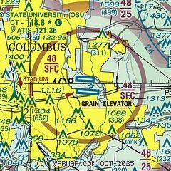
|
CAUTION: Diagram may not be current
 Download PDF
of official airport diagram from the FAA
| Airport distance calculator |
|---|
|
|
| Sunrise and sunset |
|---|
|
Times for 30-Apr-2026
| | Local
(UTC-4) | | Zulu
(UTC) |
|---|
| Morning civil twilight | | 06:05 | | 10:05 |
| Sunrise | | 06:34 | | 10:34 |
| Sunset | | 20:24 | | 00:24 |
| Evening civil twilight | | 20:53 | | 00:53 |
|
| Current date and time |
|---|
| Zulu (UTC) | 30-Apr-2026 22:15:06 |
|---|
| Local (UTC-4) | 30-Apr-2026 18:15:06 |
|---|
|
| METAR |
|---|
| KCMH | 302151Z 30007KT 10SM SCT065 14/M01 A2996 RMK AO2 SLP148 T01391011
|
KOSU
10nm NW | 302153Z 33006KT 10SM SCT065 13/M01 A2997 RMK AO2 SLP150 T01281011
|
KLCK
11nm S | 302155Z AUTO 30011KT 10SM BKN060 14/01 A2998 RMK AO2 T01400010
|
KTZR
13nm SW | 302147Z 29010G16KT 10SM BKN055 14/02 A2998
|
KLHQ
18nm SE | 302153Z AUTO 31008KT 10SM SCT055 SCT070 13/02 A2997 RMK AO2 SLP151 T01330022
|
KVTA
20nm E | 302154Z AUTO VRB04KT 10SM FEW050 13/02 A2996 RMK AO2 SLP145 T01280022
|
KDLZ
20nm NW | 302155Z AUTO 30007KT 260V320 10SM BKN065 OVC070 14/01 A2996 RMK AO2
|
|
| TAF |
|---|
| KCMH | 301721Z 3018/0118 32009KT P6SM SCT035 FM010700 VRB05KT P6SM BKN070 FM011000 21005KT P6SM -SHRA BKN025 FM011400 24006KT P6SM -SHRA BKN018 FM011700 29009KT P6SM BKN022
|
KLCK
11nm S | 301721Z 3018/0118 32009KT P6SM SCT035 FM010700 VRB05KT P6SM BKN070 FM011000 21005KT P6SM -SHRA BKN025 FM011400 24006KT P6SM -SHRA BKN018 FM011700 29009KT P6SM BKN022
|
|
| NOTAMs |
|---|
NOTAMs are issued by the DoD/FAA and will open in a separate window not controlled by AirNav.
|
|


