FAA INFORMATION EFFECTIVE 10 JULY 2025
Location
| FAA Identifier: | EPM |
| Lat/Long: | 44-54-36.4000N 067-00-45.7000W
44-54.606667N 067-00.761667W
44.9101111,-67.0126944
(estimated) |
| Elevation: | 45.3 ft. / 13.8 m (surveyed) |
| Variation: | 16W (2025) |
| From city: | 1 mile W of EASTPORT, ME |
| Time zone: | UTC -4 (UTC -5 during Standard Time) |
| Zip code: | 04631 |
Airport Operations
| Airport use: | Open to the public |
| Activation date: | 12/1942 |
| Control tower: | no |
| ARTCC: | BOSTON CENTER |
| FSS: | BANGOR FLIGHT SERVICE STATION |
| NOTAMs facility: | EPM (NOTAM-D service available) |
| Attendance: | UNATNDD |
| Wind indicator: | lighted |
| Segmented circle: | no |
| Lights: | ACTVT REIL RWY 14 & 32; PAPI RWY 14 & 32; MIRL RWY 14/32 - CTAF. |
| Beacon: | white-green (lighted land airport)
Operates sunset to sunrise. |
| International operations: | customs landing rights airport |
Airport Communications
| CTAF/UNICOM: | 122.8 |
| WX AWOS-AV: | 122.8 (207-853-0682) |
- APCH/DEP SVC PRVDD BY BOSTON ARTCC ON FREQ 124.25/290.50 (BANGOR RCAG).
Airport Services
| Fuel available: | 100LL JET-A+ |
| Parking: | tiedowns |
| Airframe service: | MAJOR |
| Powerplant service: | MAJOR |
| Bottled oxygen: | NONE |
| Bulk oxygen: | NONE |
Runway Information
Runway 14/32
| Dimensions: | 4002 x 75 ft. / 1220 x 23 m |
| Surface: | asphalt, in good condition |
| Weight bearing capacity: | |
| Runway edge lights: | medium intensity |
| RUNWAY 14 | | RUNWAY 32 |
| Latitude: | 44-54.803092N | | 44-54.411327N |
| Longitude: | 067-01.133747W | | 067-00.388895W |
| Elevation: | 34.6 ft. | | 45.2 ft. |
| Traffic pattern: | left | | left |
| Runway heading: | 143 magnetic, 127 true | | 323 magnetic, 307 true |
| Markings: | nonprecision, in good condition | | nonprecision, in good condition |
| Visual slope indicator: | 2-light PAPI on left (3.10 degrees glide path)
PAPI UNUSBL BYD 6 DEGS L OF CNTRLN. | | 2-light PAPI on left (3.28 degrees glide path) |
| Runway end identifier lights: | yes | | yes |
| Touchdown point: | yes, no lights | | yes, no lights |
| Obstructions: | 12 ft. tree, lighted, 205 ft. from runway, 75 ft. left of centerline
3-5 FT BRUSH 20-200 FT FM THR, 100-200 FT R OF CNTRLN; 8 FT BERM 0-125 FT FM THR, 190 FT R OF CNTRLNE; 6-8 FT BRUSH, 100-200 FT FM THR, 65-200 FT L CNTRLN. | | none
3-9 FT WEEDS AND GRASS 100-200 FT FM THR, 75-250 FT R OF CNTRLN; 2-5 FT RISING TERRAIN 50-120 FT FM THR, 125 FT L OF CNTRLN. |
Airport Ownership and Management from official FAA records
| Ownership: | Publicly-owned |
| Owner: | CITY OF EASTPORT
22 WASHINGTON ST
EASTPORT, ME 04631
Phone 207-853-2300 |
| Manager: | PETE LEHMANN
1 AIRPORT RD
EASTPORT, ME 04631
Phone 207-214-4751 |
Additional Remarks
| - | DEER & NMRS BIRDS ON & INVOF RWY. |
| - | REQ CUST AT 207-853-4313. |
| - | 24 HR SELF-SVC FUEL AVBL WITH CREDIT CARD. |
| - | 40-50 FT OBSTN LGTS ON POLES 250 FT R OF CNTRLN NEAR RWY 14 END & APCH AREA. |
| - | FOR CD CTC BOSTON ARTCC AT 603-879-6859. |
| - | JET-A FUEL PUMP LMTD TO OVR WING GRAVITY RFLG OPS. |
Instrument Procedures
NOTE: All procedures below are presented as PDF files. If you need a reader for these files, you should download the free Adobe Reader.NOT FOR NAVIGATION. Please procure official charts for flight.
FAA instrument procedures published for use from 10 July 2025 at 0901Z to 07 August 2025 at 0900z.
IAPs - Instrument Approach Procedures |
|---|
| RNAV (GPS) RWY 14 **CHANGED** | |
download (257KB) |
| RNAV (GPS) RWY 32 **CHANGED** | |
download (277KB) |
| NOTE: Special Alternate Minimums apply | |
download (153KB) |
| NOTE: Special Take-Off Minimums/Departure Procedures apply | |
download (546KB) |
Other nearby airports with instrument procedures:
KMVM - Machias Valley Airport (23 nm SW)
KPNN - Princeton Municipal Airport (29 nm NW)
43B - Deblois Flight Strip (43 nm W)
KBHB - Hancock County/Bar Harbor Airport (64 nm SW)
KLRG - Lincoln Regional Airport (70 nm NW)
|
|

Road maps at:
MapQuest
Bing
Google
| Aerial photo |
|---|
WARNING: Photo may not be current or correct
 Photo courtesy of Jim Lowe
Taken in 2014
Photo courtesy of Jim Lowe
Taken in 2014
Do you have a better or more recent aerial photo of Eastport Municipal Airport that you would like to share? If so, please send us your photo.
|
| Sectional chart |
|---|
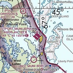
|
| Airport distance calculator |
|---|
|
|
| Sunrise and sunset |
|---|
|
Times for 19-Jul-2025
| | Local
(UTC-4) | | Zulu
(UTC) |
|---|
| Morning civil twilight | | 04:25 | | 08:25 |
| Sunrise | | 05:01 | | 09:01 |
| Sunset | | 20:08 | | 00:08 |
| Evening civil twilight | | 20:43 | | 00:43 |
|
| Current date and time |
|---|
| Zulu (UTC) | 20-Jul-2025 01:38:48 |
|---|
| Local (UTC-4) | 19-Jul-2025 21:38:48 |
|---|
|
| METAR |
|---|
CWSS
20nm NW | 200000Z AUTO 20005KT 22/12 RMK AO1 SLP145 T02150118 51001
|
CWPE
25nm E | 200000Z AUTO 22006KT 16/11 RMK AO1 SLP149 T01600108 58003
|
|
| NOTAMs |
|---|
NOTAMs are issued by the DoD/FAA and will open in a separate window not controlled by AirNav.
|
|


