FAA INFORMATION EFFECTIVE 14 MAY 2026
Location
| FAA Identifier: | PNN |
| Lat/Long: | 45-12-02.3750N 067-33-51.8360W
45-12.039583N 067-33.863933W
45.2006597,-67.5643989
(estimated) |
| Elevation: | 264.9 ft. / 80.7 m (surveyed) |
| Variation: | 17W (2015) |
| From city: | 2 miles S of PRINCETON, ME |
| Time zone: | UTC -4 (UTC -5 during Standard Time) |
| Zip code: | 04668 |
Airport Operations
| Airport use: | Open to the public |
| Activation date: | 03/1943 |
| Control tower: | no |
| ARTCC: | BOSTON CENTER |
| FSS: | BANGOR FLIGHT SERVICE STATION |
| NOTAMs facility: | BGR (NOTAM-D service available) |
| Attendance: | UNATNDD |
| Wind indicator: | lighted |
| Segmented circle: | yes |
| Lights: | ACTVT PAPI RWY 15; MIRL RWY 15/33 - CTAF. |
| Beacon: | white-green (lighted land airport)
Operates sunset to sunrise. |
| International operations: | customs landing rights airport |
Airport Communications
| CTAF/UNICOM: | 122.7 |
| WX AWOS-AV: | 122.7 |
- AUTOMATED UNICOM; 3 CLICKS.
- APCH/DEP SVC PRVDD BY BOSTON ARTCC ON FREQ 124.25/290.50 (BANGOR RCAG).
Airport Services
| Fuel available: | 100LL
100LL:AVBL 24 HRS WITH MAJOR CREDIT CARD. |
| Parking: | tiedowns |
| Airframe service: | NONE |
| Powerplant service: | NONE |
| Bottled oxygen: | NONE |
| Bulk oxygen: | NONE |
Runway Information
Runway 15/33
| Dimensions: | 4007 x 75 ft. / 1221 x 23 m |
| Surface: | asphalt, in excellent condition |
| Weight bearing capacity: | | Single wheel: | 31.0 | | Double wheel: | 38.0 |
|
| Runway edge lights: | medium intensity |
| RUNWAY 15 | | RUNWAY 33 |
| Latitude: | 45-12.245822N | | 45-11.799808N |
| Longitude: | 067-34.404498W | | 067-33.717488W |
| Elevation: | 263.4 ft. | | 252.3 ft. |
| Traffic pattern: | left | | left |
| Runway heading: | 150 magnetic, 133 true | | 330 magnetic, 313 true |
| Markings: | nonprecision, in fair condition | | nonprecision, in fair condition |
| Visual slope indicator: | 4-light PAPI on left (3.50 degrees glide path) | | |
| Runway end identifier lights: | no | | no |
| Touchdown point: | yes, no lights | | yes, no lights |
| Obstructions: | 3 ft. tree, 226 ft. from runway, 91 ft. left of centerline, 8:1 slope to clear
BRUSH 100-200 FT L AND 75-170 FT R OF RWY. | | none |
Runway 6/24
| Dimensions: | 3998 x 150 ft. / 1219 x 46 m |
| Surface: | asphalt/L |
| Runway edge markings: | RWY 06/24 MKD WITH YELLOW CLOSURE AT BOTH ENDS & MID OF RWY. DTHR MARKINGS ARE NOT VSB. |
| Operational restrictions: | CLSD INDEFLY - PAVEMENT UNUSBL. |
| RUNWAY 6 | | RUNWAY 24 |
| Latitude: | 45-11.798983N | | 45-12.313748N |
| Longitude: | 067-33.956225W | | 067-33.376622W |
| Elevation: | 238.6 ft. | | 245.5 ft. |
| Traffic pattern: | left | | left |
| Runway heading: | 056 magnetic, 039 true | | 236 magnetic, 219 true |
| Displaced threshold: | no | | 503 ft. |
| Markings: | numbers only, in poor condition | | numbers only, in poor condition |
| Touchdown point: | yes, no lights | | yes, no lights |
| Obstructions: | 25 ft. trees, 201 ft. from runway | | 25 ft. trees, 201 ft. from runway
20-35 FT TREES 20 FT FM THR, 125 FT L & R ACRS APCH. |
Airport Ownership and Management from official FAA records
| Ownership: | Publicly-owned |
| Owner: | TOWN OF PRINCETON
TOWN OFFICES
PRINCETON, ME 04668
Phone 207-796-2744 |
| Manager: | BRAD RICHARD
PO BOX 346
PRINCETON, ME 04668
Phone 207-214-5144 |
Additional Remarks
| - | WILDLIFE ON & INVOF ARPT. |
| - | FOR CD CTC BOSTON ARTCC AT 603-879-6859. |
Instrument Procedures
NOTE: All procedures below are presented as PDF files. If you need a reader for these files, you should download the free Adobe Reader.NOT FOR NAVIGATION. Please procure official charts for flight.
FAA instrument procedures published for use from 14 May 2026 at 0901Z to 11 June 2026 at 0900Z.
IAPs - Instrument Approach Procedures |
|---|
| RNAV (GPS) RWY 15 **CHANGED** | |
download (257KB) |
| RNAV (GPS) RWY 33 **CHANGED** | |
download (275KB) |
| NOTE: Special Take-Off Minimums/Departure Procedures apply | |
download |
Other nearby airports with instrument procedures:
KEPM - Eastport Municipal Airport (29 nm SE)
KMVM - Machias Valley Airport (30 nm S)
43B - Deblois Flight Strip (34 nm SW)
KLRG - Lincoln Regional Airport (42 nm W)
KOLD - Dewitt Field/Old Town Municipal Airport (49 nm W)
|
|

Road maps at:
MapQuest
Bing
Google
| Aerial photo |
|---|
WARNING: Photo may not be current or correct

Do you have a better or more recent aerial photo of Princeton Municipal Airport that you would like to share? If so, please send us your photo.
|
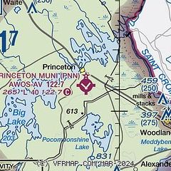
| Sectional chart |
|---|
|
| Airport distance calculator |
|---|
|
|
| Sunrise and sunset |
|---|
|
Times for 15-May-2026
| | Local
(UTC-4) | | Zulu
(UTC) |
|---|
| Morning civil twilight | | 04:27 | | 08:27 |
| Sunrise | | 05:02 | | 09:02 |
| Sunset | | 19:52 | | 23:52 |
| Evening civil twilight | | 20:26 | | 00:26 |
|
| Current date and time |
|---|
| Zulu (UTC) | 15-May-2026 20:35:24 |
|---|
| Local (UTC-4) | 15-May-2026 16:35:24 |
|---|
|
| METAR |
|---|
CWSS
13nm E | 152000Z AUTO 05006KT 17/07 RMK AO1 SLP107 T01730074 58008
|
|
| NOTAMs |
|---|
NOTAMs are issued by the DoD/FAA and will open in a separate window not controlled by AirNav.
|
|

