FAA INFORMATION EFFECTIVE 09 JULY 2026
Location
| FAA Identifier: | FAT |
| Lat/Long: | 36-46-35.6000N 119-43-07.8000W
36-46.593333N 119-43.130000W
36.7765556,-119.7188333
(estimated) |
| Elevation: | 335.5 ft. / 102.3 m (surveyed) |
| Variation: | 13E (2020) |
| From city: | 5 miles NE of FRESNO, CA |
| Time zone: | UTC -7 (UTC -8 during Standard Time) |
| Zip code: | 93727 |
Airport Operations
| Airport use: | Open to the public |
| Activation date: | 06/1942 |
| Control tower: | yes |
| ARTCC: | OAKLAND CENTER |
| FSS: | RANCHO MURIETA FLIGHT SERVICE STATION |
| NOTAMs facility: | FAT (NOTAM-D service available) |
| Attendance: | CONTINUOUS |
| Pattern altitude: | 1302.5 ft. MSL
TPA: 967 FT AGL 1303 FT MSL SINGLE ENGINE ACFT ; 1467 FT AGL 1803 FT MSL MULTI-ENGINE ACFT; 1967 FT AGL 2303 FT MSL TURBOJET; HELICOPTERS 467 FT AGL 803 FT MSL. |
| Wind indicator: | lighted |
| Segmented circle: | yes |
| Beacon: | white-green (lighted land airport)
Operates sunset to sunrise. |
| Landing fee: | no, FEE FOR ACFT OVER 12500 LBS GWT. |
| Fire and rescue: | ARFF index C |
| International operations: | US CUSTOMS USER FEE ARPT. |
Airport Communications
| UNICOM: | 122.95 |
| ATIS: | 121.35 273.6 |
| WX ASOS: | PHONE 559-203-3918 |
| FRESNO GROUND: | 121.7 348.6 |
| FRESNO TOWER: | 118.2 251.1 |
| FRESNO APPROACH: | 119.6 ;240-090 132.35 ;091-239 323.25 ;091-239 351.95 ;240-090 118.5 ;S/SE VISALIA AREA 268.7 ;S/SE VISALIA AREA |
| FRESNO DEPARTURE: | 119.6 ;240-090 132.35 ;091-239 323.25 ;091-239 351.95 ;240-090 118.5 ;S/SE VISALIA AREA 268.7 ;S/SE VISALIA AREA |
| CLEARANCE DELIVERY: | 124.35 348.6 |
| ANG OPS: | 140.0 298.3 |
| CLASS C: | 119.6 ;240-090 132.35 ;091-239 323.25 ;091-239 351.95 ;240-090 |
| EMERG: | 121.5 243.0 |
| IC: | 119.6 ;240-090 351.95 ;240-090 |
| NG OPS: | 132.0 255.8 40.95 |
| WX AWOS-3 at FCH (6 nm SW): | 135.225 (559-488-1040) |
| WX AWOS-3PT at O32 (14 nm SE): | 120.175 (559-637-9453) |
- ANG OPNS CALL IS GRIFFIN OERATIONS.
Nearby radio navigation aids
| VOR radial/distance | | VOR name | | Freq | | Var |
|---|
| FRAr180/20.5 | | FRIANT VORTAC | | 115.60 | | 17E |
Airport Services
| Fuel available: | 100 JET-A JET-A++ |
| Parking: | hangars and tiedowns |
| Airframe service: | MAJOR |
| Powerplant service: | MAJOR |
| Bottled oxygen: | HIGH/LOW |
| Bulk oxygen: | HIGH |
Runway Information
Runway 11L/29R
| Dimensions: | 9539 x 150 ft. / 2907 x 46 m |
| Surface: | asphalt/grooved, in fair condition |
| Weight bearing capacity: | | Single wheel: | 70.0 | | Double wheel: | 170.0 | | Double tandem: | 250.0 |
|
| Runway edge lights: | high intensity |
| Operational restrictions: | RY 11L/29R RY 11L 1000 FT BLAST PAD; RY 29R 850 FT BLAST PAD. |
| RUNWAY 11L | | RUNWAY 29R |
| Latitude: | 36-47.040100N | | 36-46.130380N |
| Longitude: | 119-43.805135W | | 119-42.211497W |
| Elevation: | 333.0 ft. | | 332.0 ft. |
| Traffic pattern: | left | | right |
| Runway heading: | 112 magnetic, 125 true | | 292 magnetic, 305 true |
| Displaced threshold: | no | | 312 ft. |
| Declared distances: | TORA:9539 TODA:9539 ASDA:9279 LDA:9279 | | TORA:9539 TODA:9539 ASDA:9539 LDA:9227 |
| Markings: | precision, in good condition | | precision, in good condition |
| Visual slope indicator: | 4-light PAPI on left (3.00 degrees glide path) | | 4-light PAPI on left (3.00 degrees glide path) |
| RVR equipment: | touchdown, midfield, rollout | | touchdown, midfield, rollout |
| Approach lights: | | | ALSF2: standard 2,400 foot high intensity approach lighting system with centerline sequenced flashers (category II or III) |
| Runway end identifier lights: | yes | | no |
| Centerline lights: | yes | | yes |
| Touchdown point: | yes, no lights | | yes, lighted |
| Instrument approach: | LOC/DME | | ILS/DME |
| Obstructions: | 67 ft. tree, 755 ft. from runway, 780 ft. left of centerline, 8:1 slope to clear | | 16 ft. road, lighted, 750 ft. from runway, 580 ft. right of centerline, 34:1 slope to clear |
Runway 11R/29L
| Dimensions: | 8008 x 150 ft. / 2441 x 46 m |
| Surface: | asphalt/grooved, in good condition |
| Weight bearing capacity: | | Single wheel: | 70.0 | | Double wheel: | 170.0 | | Double tandem: | 250.0 |
|
| Runway edge lights: | medium intensity |
| Operational restrictions: | RY 11R/29L RY 11R 1000 FT BLAST PAD; RY 29L 1000 FT BLAST PAD. |
| RUNWAY 11R | | RUNWAY 29L |
| Latitude: | 36-46.983695N | | 36-46.220070N |
| Longitude: | 119-43.945285W | | 119-42.607337W |
| Elevation: | 330.0 ft. | | 329.9 ft. |
| Traffic pattern: | right | | left |
| Runway heading: | 112 magnetic, 125 true | | 292 magnetic, 305 true |
| Declared distances: | TORA:8008 TODA:8008 ASDA:8008 LDA:8008 | | TORA:8008 TODA:8008 ASDA:8008 LDA:8008 |
| Markings: | precision, in good condition | | precision, in good condition |
| Visual slope indicator: | | | 4-light PAPI on left (3.00 degrees glide path) |
| Runway end identifier lights: | yes | | |
| Touchdown point: | yes, no lights | | yes, no lights |
Airport Ownership and Management from official FAA records
| Ownership: | Publicly-owned |
| Owner: | CITY OF FRESNO
4995 E CLINTON WAY
FRESNO, CA 93727
Phone 559-621-4500 |
| Manager: | FRANCISCO PARTIDA
4995 E CLINTON WAY
FRESNO, CA 93722
Phone 559-621-4531
OPS MGR - SEVAN GHAZARIANS: OFC 559-621-4508; CELL 559-840-7315; 24 HR OPNS 559-978-1835. |
Additional Remarks
| A39-11L/29R | PCR VALUE: 505/F/A/X/T |
| A39-11R/29L | PCR VALUE: 492/F/A/X/T |
| E60-29R | BAK-14 BAK-12B(B) (1310') |
| E60-11L | BAK-14 BAK-12B(B) (1500') |
| - | NUMEROUS BIRDS INVOF ARPT. |
| - | LGTD RY DISTANCE REMAINING MARKERS ON SOUTH SIDE OF RY 11R/29L; LGTD RY DISTANCE REMAINING MARKERS BOTH SIDES OF RY 11L/29R- 11L DRM ON NORTH SIDE; 29R DRM ON SOUTH SIDE. |
| - | RETRACTABLE BAK-12/14 AVBL ON RWY 11L AND RWY 29R ARE KEPT IN RECESSED PSN UNTIL REQ FOR USE; TWR MUST BE NTFD AT LEAST 5 SECS PRIOR TO ENGAGEMENT SO THAT THE A-GEAR CABLE MAY BE RAISED. MB-100 ARST CABLE INSTLD AT RWY 11R BLAST PAD FOR RWY 29L DEPS ONLY. |
| - | MILITARY: ANG: CTC ANG OPS FOR LCL BIRD WATCH COND (BWC). |
| - | MILITARY: SVC: RWY 29R AND 11L A-GEAR CABLE AVBL UPON REQ ONLY; DEFAULT POSN DOWN. |
| - | TWY B3 CLSD BTN RWY 11L/29R AND RWY 11R/29L. |
| - | TWY A LTD TO ACFT DESIGN GROUP II. |
| - | ATCT CLNC RQRD TO PUSH ON MOV AREA. |
| - | PPR FOR ENG START AT ACR TRML GATES & ENG RUN-UP. |
| - | FRESNO YOSEMITE INTL IS NOISE SENSITIVE; NOISE ABATEMENT PROCEDURES IN EFFECT. |
| - | NO MULT APCHS AND LNDGS MON-SAT 2200-0700 AND SUN 1800-1000. |
| - | POSSIBLE WAKE TURBULENCE OR WIND SHEAR ARR TO RY 29L OR DEP FM RY 11R. JET TESTING CONDUCTED AT AIR NATIONAL GUARD RAMP LCTD AT SE CORNER OF ARPT. |
Instrument Procedures
NOTE: All procedures below are presented as PDF files. If you need a reader for these files, you should download the free Adobe Reader.NOT FOR NAVIGATION. Please procure official charts for flight.
FAA instrument procedures published for use from 09 July 2026 at 0901Z to 06 August 2026 at 0900Z.
STARs - Standard Terminal Arrivals |
|---|
| ALTTA NINE **NEW** | |
download (139KB) |
IAPs - Instrument Approach Procedures |
|---|
| HI-ILS Z OR LOC Z RWY 29R | |
download (230KB) |
| ILS Y OR LOC Y RWY 29R | |
download (310KB) |
| ILS Y RWY 29R (SA CAT I) | |
download (265KB) |
| ILS Y RWY 29R (CAT II - III) | |
download (272KB) |
| RNAV (GPS) RWY 11L | |
download (222KB) |
| RNAV (GPS) RWY 11R | |
download (226KB) |
| RNAV (GPS) RWY 29L | |
download (229KB) |
| RNAV (GPS) RWY 29R | |
download (228KB) |
| HI-LOC Z RWY 11L | |
download (132KB) |
| LOC Y RWY 11L | |
download (218KB) |
| HI-TACAN RWY 11L | |
download (130KB) |
| HI-TACAN RWY 29R | |
download (137KB) |
| TACAN RWY 11L | |
download (209KB) |
| TACAN RWY 29R | |
download (282KB) |
| NOTE: Special Alternate Minimums apply | |
download (51KB) |
Departure Procedures |
|---|
| BULLDOG THREE | |
download (123KB) |
| COALDALE FOUR | |
download (165KB) |
| YOSEMITE THREE | |
download (161KB) |
| NOTE: Special Take-Off Minimums/Departure Procedures apply | |
download (336KB) |
Other nearby airports with instrument procedures:
KFCH - Fresno Chandler Executive Airport (6 nm SW)
O32 - Reedley Municipal Airport (14 nm SE)
KMAE - Madera Municipal Airport (23 nm NW)
KHJO - Hanford Municipal Airport (28 nm S)
KNLC - Lemoore Naval Air Station (Reeves Field) (29 nm SW)
|
|

Road maps at:
MapQuest
Bing
Google
| Aerial photo |
|---|
WARNING: Photo may not be current or correct
 Photo by David Newcomer
Photo taken 25-Sep-2011
from 3,000' altitude looking west
Photo by David Newcomer
Photo taken 25-Sep-2011
from 3,000' altitude looking west
Do you have a better or more recent aerial photo of Fresno Yosemite International Airport that you would like to share? If so, please send us your photo.
|
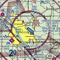
| Sectional chart |
|---|
|
CAUTION: Diagram may not be current
 Download PDF
of official airport diagram from the FAA
| Airport distance calculator |
|---|
|
|
| Sunrise and sunset |
|---|
|
Times for 10-Jul-2026
| | Local
(UTC-7) | | Zulu
(UTC) |
|---|
| Morning civil twilight | | 05:19 | | 12:19 |
| Sunrise | | 05:49 | | 12:49 |
| Sunset | | 20:19 | | 03:19 |
| Evening civil twilight | | 20:49 | | 03:49 |
|
| Current date and time |
|---|
| Zulu (UTC) | 11-Jul-2026 03:28:44 |
|---|
| Local (UTC-7) | 10-Jul-2026 20:28:44 |
|---|
|
| METAR |
|---|
| KFAT | 110253Z 32013KT 10SM FEW130 FEW200 36/11 A2976 RMK AO2 SLP073 FU DSNT E-SE T03610106 55001 $
|
KFCH
6nm SW | 110315Z AUTO 30008KT 10SM CLR 34/14 A2978 RMK A01
|
KO32
14nm SE | 110315Z AUTO 31006KT 8SM CLR 32/06 A2974 RMK AO2 T03230063 $
|
|
| TAF |
|---|
| KFAT | 101720Z 1018/1118 31009KT P6SM SKC
|
|
| NOTAMs |
|---|
NOTAMs are issued by the DoD/FAA and will open in a separate window not controlled by AirNav.
|
|


