FAA INFORMATION EFFECTIVE 19 FEBRUARY 2026
Location
| FAA Identifier: | FBL |
| Lat/Long: | 44-19-44.2898N 093-18-47.0651W
44-19.738163N 093-18.784418W
44.3289694,-93.3130736
(estimated) |
| Elevation: | 1060.1 ft. / 323.1 m (surveyed) |
| Variation: | 02E (2000) |
| From city: | 3 miles NW of FARIBAULT, MN |
| Time zone: | UTC -6 (UTC -5 during Daylight Saving Time) |
| Zip code: | 55021 |
Airport Operations
| Airport use: | Open to the public |
| Activation date: | 04/1947 |
| Control tower: | no |
| ARTCC: | MINNEAPOLIS CENTER |
| FSS: | PRINCETON FLIGHT SERVICE STATION |
| NOTAMs facility: | FBL (NOTAM-D service available) |
| Attendance: | MAY-SEP 0800-1800, OCT-APR SAT 1000-1500, OCT-APR SUN UNATNDD, OCT-APR MON-FRI 0800-1800
FOR SVS AFT HRS CALL 507-838-7152 |
| Wind indicator: | lighted |
| Segmented circle: | no |
| Lights: | MIRL RY 12/30 PRESET TO LOW; TO INCR INTST AND ACTVT REIL RY 12 & RY 30 - CTAF. |
| Beacon: | white-green (lighted land airport)
Operates sunset to sunrise. |
Airport Communications
| CTAF/UNICOM: | 122.8 |
| WX AWOS-3: | 120.2 (507-332-2505) |
| MINNEAPOLIS APPROACH: | 134.7 |
| MINNEAPOLIS DEPARTURE: | 134.7 |
| WX AWOS-3 at OWA (13 nm S): | 128.325 (507-455-0642) |
| WX AWOS-3 at SYN (15 nm NE): | 119.35 (507-664-3806) |
| WX AWOS-3 at LVN (18 nm N): | 118.0 (952-469-5850) |
| WX AWOS-3 at ACQ (18 nm SW): | 118.425 (507-835-3657) |
Nearby radio navigation aids
| VOR radial/distance | | VOR name | | Freq | | Var |
|---|
| FOWr016/7.9 | | HALFWAY VOR/DME | | 111.20 | | 02E |
| FGTr191/19.0 | | FARMINGTON VORTAC | | 115.70 | | 06E |
| FCMr168/30.3 | | FLYING CLOUD VOR/DME | | 117.70 | | 01E |
| MSPr183/34.2 | | MINNEAPOLIS VOR/DME | | 115.30 | | 02E |
| AELr003/38.9 | | ALBERT LEA VOR/DME | | 109.80 | | 01E |
Airport Services
| Fuel available: | 100LL JET-A
100LL:SELF SVC FUEL WITH CREDIT CARD. |
| Parking: | hangars and tiedowns |
| Airframe service: | MAJOR |
| Powerplant service: | MAJOR |
| Bottled oxygen: | LOW |
| Bulk oxygen: | NONE |
Runway Information
Runway 12/30
| Dimensions: | 4257 x 75 ft. / 1298 x 23 m |
| Surface: | asphalt, in fair condition |
| Weight bearing capacity: | | Single wheel: | 16.0 | | Double wheel: | 22.0 |
|
| Runway edge lights: | medium intensity |
| RUNWAY 12 | | RUNWAY 30 |
| Latitude: | 44-19.887650N | | 44-19.465073N |
| Longitude: | 093-19.086048W | | 093-18.307658W |
| Elevation: | 1060.0 ft. | | 1048.4 ft. |
| Traffic pattern: | left | | left |
| Runway heading: | 125 magnetic, 127 true | | 305 magnetic, 307 true |
| Displaced threshold: | no | | 230 ft. |
| Markings: | nonprecision, in fair condition | | nonprecision, in fair condition |
| Visual slope indicator: | 4-light PAPI on left (3.00 degrees glide path)
RY 12 PAPI OPERATE CONTINUOUSLY. | | 4-light PAPI on left (3.00 degrees glide path)
RY 30 PAPI OPERATE CONTINUOUSLY. |
| Runway end identifier lights: | yes | | yes |
| Touchdown point: | yes, no lights | | yes, no lights |
| Obstructions: | 37 ft. tree, 263 ft. from runway, 246 ft. right of centerline, 1:1 slope to clear
RWY 12 HAS 20 FT TREE 120 FT FM THE RWY END AND 153 FT R. | | 14 ft. road, 580 ft. from runway, 280 ft. right of centerline, 27:1 slope to clear
RY 30 ROAD +14, 580 FM END, 280R, APCH SLOPE 57:1 FM DSPLCD THLD. |
Runway 1/19
| Dimensions: | 2300 x 175 ft. / 701 x 53 m |
| Surface: | turf, in fair condition |
| Runway edge markings: | RY 01/19 MARKED WITH YELLOW CONES. |
| RUNWAY 1 | | RUNWAY 19 |
| Latitude: | 44-19.665988N | | 44-20.039117N |
| Longitude: | 093-18.990865W | | 093-18.902148W |
| Elevation: | 1051.3 ft. | | 1054.6 ft. |
| Traffic pattern: | left | | left |
| Runway heading: | 008 magnetic, 010 true | | 188 magnetic, 190 true |
| Markings: | NSTD, in fair condition | | NSTD, in fair condition |
| Touchdown point: | yes, no lights | | yes, no lights |
| Obstructions: | 78 ft. trees, 1295 ft. from runway, 221 ft. left of centerline, 16:1 slope to clear | | none |
Airport Ownership and Management from official FAA records
| Ownership: | Publicly-owned |
| Owner: | CITY OF FARIBAULT
208 1ST AVE, NW
FARIBAULT, MN 55021
Phone 507-334-2222 |
| Manager: | QUALITY AVIATION INC.
3401 HWY 21 WEST, STE 1
FARIBAULT, MN 55021
Phone 507-332-0140 |
Additional Remarks
| - | GCO AVBL ON FREQ 121.725 THRU MSP CD & FLT SVCS. |
| - | ULTRALIGHTS & GLDRS USE TAXIWAY AND EXTENDED TAXIWAY PARALLEL TO RY 12/30. ULTRALIGHTS & GLDRS USING TAXIWAY FLY PATTERN ON 'NE' SIDE OF RY 12/30. |
| - | WHEN LNDG ON RY 12, BE ALERT FOR TURBULENCE & POSS WINDSHEAR WHEN WINDS ARE OUT OF THE SOUTH. |
| - | FOR CD CTC MINNEAPOLIS APCH AT 612-726-9086. |
| - | RWY 01-19 NOT PLOWED WINTER MONTHS. OPEN FOR SKIPLANES. |
Instrument Procedures
NOTE: All procedures below are presented as PDF files. If you need a reader for these files, you should download the free Adobe Reader.NOT FOR NAVIGATION. Please procure official charts for flight.
FAA instrument procedures published for use from 19 February 2026 at 0901Z to 19 March 2026 at 0900Z.
STARs - Standard Terminal Arrivals |
|---|
| AGUDE SIX | |
download (218KB) |
IAPs - Instrument Approach Procedures |
|---|
| RNAV (GPS) RWY 12 | |
download (226KB) |
| RNAV (GPS) RWY 30 | |
download (244KB) |
| VOR-A | |
download (168KB) |
| NOTE: Special Alternate Minimums apply | |
download (81KB) |
| NOTE: Special Take-Off Minimums/Departure Procedures apply | |
download (313KB) |
Other nearby airports with instrument procedures:
KOWA - Owatonna Degner Regional Airport (13 nm S)
KLVN - Airlake Airport (18 nm N)
KACQ - Waseca Municipal Airport/Maynard Richard Stensrud Field (18 nm SW)
KMKT - Mankato Regional Airport (27 nm W)
KTOB - Dodge Center Airport (28 nm SE)
|
|

Road maps at:
MapQuest
Bing
Google
| Aerial photo |
|---|
WARNING: Photo may not be current or correct
 Photo by Gary Chambers
Photo taken 13-Aug-2007
Photo by Gary Chambers
Photo taken 13-Aug-2007
Do you have a better or more recent aerial photo of Faribault Municipal Airport-Liz Wall Strohfus Field that you would like to share? If so, please send us your photo.
|
| Sectional chart |
|---|
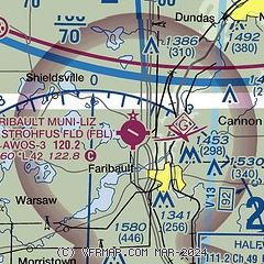
|
| Airport distance calculator |
|---|
|
|
| Sunrise and sunset |
|---|
|
Times for 17-Mar-2026
| | Local
(UTC-5) | | Zulu
(UTC) |
|---|
| Morning civil twilight | | 06:54 | | 11:54 |
| Sunrise | | 07:23 | | 12:23 |
| Sunset | | 19:20 | | 00:20 |
| Evening civil twilight | | 19:49 | | 00:49 |
|
| Current date and time |
|---|
| Zulu (UTC) | 17-Mar-2026 06:39:54 |
|---|
| Local (UTC-5) | 17-Mar-2026 01:39:54 |
|---|
|
| METAR |
|---|
| KFBL | 170615Z AUTO 31005KT 10SM CLR M15/M21 A3011 RMK AO2
|
KOWA
13nm S | 170615Z AUTO 33006KT 10SM CLR M18/M22 A3010 RMK AO2 T11781216
|
KSYN
15nm NE | 170615Z AUTO 31007KT 10SM CLR M18/M22 A3012 RMK AO2 T11771221
|
KLVN
18nm N | 170615Z AUTO 29005KT 10SM CLR M17/M22 A3012 RMK AO2
|
KACQ
19nm SW | 170615Z AUTO 30009KT 10SM CLR M15/M20 A3013 RMK AO2
|
|
| NOTAMs |
|---|
NOTAMs are issued by the DoD/FAA and will open in a separate window not controlled by AirNav.
|
|

