FAA INFORMATION EFFECTIVE 19 MARCH 2026
Location
| FAA Identifier: | OWA |
| Lat/Long: | 44-07-22.6265N 093-15-31.7751W
44-07.377108N 093-15.529585W
44.1229518,-93.2588264
(estimated) |
| Elevation: | 1145.4 ft. / 349.1 m (surveyed) |
| Variation: | 02E (2000) |
| From city: | 3 miles NW of OWATONNA, MN |
| Time zone: | UTC -5 (UTC -6 during Standard Time) |
| Zip code: | 55060 |
Airport Operations
| Airport use: | Open to the public |
| Activation date: | 12/1946 |
| Control tower: | no |
| ARTCC: | MINNEAPOLIS CENTER |
| FSS: | PRINCETON FLIGHT SERVICE STATION |
| NOTAMs facility: | OWA (NOTAM-D service available) |
| Attendance: | MAY-SEP SAT-SUN 1000-1600, MAY-SEP MON-FRI 0800-1700, OCT-APR MON-FRI 0800-1700, OCT-APR SAT-SUN 1100-1500 |
| Pattern altitude: | 1997.4 ft. MSL |
| Wind indicator: | lighted |
| Segmented circle: | no |
| Lights: | ACTVT MIRL RY 05/23; MALSR RY 30; REIL RY 05, 12 & 23; HIRL RY 12/30; PAPI RY 05, 12, 23, & 30 - CTAF. |
| Beacon: | white-green (lighted land airport)
Operates sunset to sunrise. |
Airport Communications
| CTAF/UNICOM: | 122.7 |
| WX AWOS-3: | 128.325 (507-455-0642) |
| ROCHESTER APPROACH: | 119.8 |
| ROCHESTER DEPARTURE: | 119.8 |
| WX AWOS-3 at FBL (13 nm N): | 120.2 (507-332-2505) |
| WX AWOS-3 at ACQ (13 nm W): | 118.425 (507-835-3657) |
| WX AWOS-3PT at TOB (19 nm E): | 119.075 (507-374-6369) |
- APCH/DEP SVC PRVDD BY MINNEAPOLIS ARTCC ON FREQS 132.35/307.3 (ROCHESTER RCAG) WHEN ROCHESTER APCH IS CLSD.
Nearby radio navigation aids
| VOR radial/distance | | VOR name | | Freq | | Var |
|---|
| FOWr133/6.9 | | HALFWAY VOR/DME | | 111.20 | | 02E |
| AELr009/26.9 | | ALBERT LEA VOR/DME | | 109.80 | | 01E |
| FGTr180/30.7 | | FARMINGTON VORTAC | | 115.70 | | 06E |
| RSTr301/35.1 | | ROCHESTER VOR/DME | | 112.00 | | 05E |
Airport Services
| Fuel available: | 100LL JET-A
A:JET A AFT HRS 507-774-7141.
100LL:100LL AVBL 24 HRS W CREDIT CARD. |
| Parking: | hangars and tiedowns |
| Airframe service: | MAJOR |
| Powerplant service: | MAJOR |
| Bottled oxygen: | NONE |
| Bulk oxygen: | NONE |
Runway Information
Runway 12/30
| Dimensions: | 5500 x 100 ft. / 1676 x 30 m |
| Surface: | concrete, in good condition |
| Weight bearing capacity: | | Single wheel: | 30.0 | | Double wheel: | 60.0 |
|
| Runway edge lights: | high intensity |
| RUNWAY 12 | | RUNWAY 30 |
| Latitude: | 44-07.656822N | | 44-07.150748N |
| Longitude: | 093-16.158000W | | 093-15.116043W |
| Elevation: | 1105.9 ft. | | 1145.4 ft. |
| Traffic pattern: | left | | left |
| Runway heading: | 122 magnetic, 124 true | | 302 magnetic, 304 true |
| Markings: | precision, in good condition | | precision, in good condition |
| Visual slope indicator: | 4-light PAPI on left (3.00 degrees glide path) | | 4-light PAPI on left (3.00 degrees glide path) |
| Approach lights: | | | MALSR: 1,400 foot medium intensity approach lighting system with runway alignment indicator lights |
| Runway end identifier lights: | yes | | no |
| Touchdown point: | yes, no lights | | yes, no lights |
| Instrument approach: | | | ILS/DME |
| Obstructions: | none | | sign |
Runway 5/23
| Dimensions: | 3000 x 75 ft. / 914 x 23 m |
| Surface: | asphalt, in good condition |
| Runway edge lights: | medium intensity |
| RUNWAY 5 | | RUNWAY 23 |
| Latitude: | 44-07.167940N | | 44-07.487540N |
| Longitude: | 093-15.593947W | | 093-15.071475W |
| Elevation: | 1137.6 ft. | | 1139.3 ft. |
| Traffic pattern: | left | | left |
| Runway heading: | 048 magnetic, 050 true | | 228 magnetic, 230 true |
| Markings: | nonprecision, in good condition | | nonprecision, in good condition |
| Visual slope indicator: | 4-light PAPI on left (3.00 degrees glide path) | | 4-light PAPI on left (3.00 degrees glide path) |
| Runway end identifier lights: | yes | | yes |
| Touchdown point: | yes, no lights | | yes, no lights |
Airport Ownership and Management from official FAA records
| Ownership: | Publicly-owned |
| Owner: | CITY OF OWATONNA
540 W HILLS CIR
OWATONNA, MN 55060-4701
Phone 507-444-4300 |
| Manager: | DAVE BEAVER
3400 W FRONTAGE RD
OWATONNA, MN 55060-5660
Phone 507-774-7141 |
Additional Remarks
| - | ULTRALIGHTS ON AND INVOF ARPT. |
| - | FOR CD CTC ROCHESTER APCH AT 507-424-8111. |
Instrument Procedures
NOTE: All procedures below are presented as PDF files. If you need a reader for these files, you should download the free Adobe Reader.NOT FOR NAVIGATION. Please procure official charts for flight.
FAA instrument procedures published for use from 19 March 2026 at 0901Z to 16 April 2026 at 0900Z.
IAPs - Instrument Approach Procedures |
|---|
| ILS OR LOC RWY 30 | |
download (258KB) |
| RNAV (GPS) RWY 12 | |
download (218KB) |
| RNAV (GPS) RWY 30 | |
download (293KB) |
| VOR RWY 12 | |
download (181KB) |
| NOTE: Special Alternate Minimums apply | |
download (175KB) |
| NOTE: Special Take-Off Minimums/Departure Procedures apply | |
download (156KB) |
Other nearby airports with instrument procedures:
KFBL - Faribault Municipal Airport-Liz Wall Strohfus Field (13 nm N)
KACQ - Waseca Municipal Airport/Maynard Richard Stensrud Field (13 nm W)
KTOB - Dodge Center Airport (19 nm E)
KAEL - Albert Lea Municipal Airport (27 nm S)
KMKT - Mankato Regional Airport (29 nm W)
|
|

Road maps at:
MapQuest
Bing
Google
| Aerial photo |
|---|
WARNING: Photo may not be current or correct
 Photo by Ed Wells
Photo taken 15-Aug-2020
looking west.
Photo by Ed Wells
Photo taken 15-Aug-2020
looking west.
Do you have a better or more recent aerial photo of Owatonna Degner Regional Airport that you would like to share? If so, please send us your photo.
|
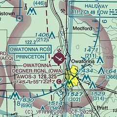
| Sectional chart |
|---|
|
CAUTION: Diagram may not be current

| Airport distance calculator |
|---|
|
|
| Sunrise and sunset |
|---|
|
Times for 05-Apr-2026
| | Local
(UTC-5) | | Zulu
(UTC) |
|---|
| Morning civil twilight | | 06:19 | | 11:19 |
| Sunrise | | 06:48 | | 11:48 |
| Sunset | | 19:44 | | 00:44 |
| Evening civil twilight | | 20:13 | | 01:13 |
|
| Current date and time |
|---|
| Zulu (UTC) | 06-Apr-2026 02:45:07 |
|---|
| Local (UTC-5) | 05-Apr-2026 21:45:07 |
|---|
|
| METAR |
|---|
| KOWA | 060235Z AUTO 32013KT 10SM CLR 04/01 A3022 RMK AO2 T00380008
|
KFBL
12nm N | 060235Z AUTO 30008KT 10SM CLR 04/00 A3023 RMK AO2
|
KACQ
13nm W | 060235Z AUTO 30012KT 10SM CLR 04/00 A3025 RMK AO2
|
|
| TAF |
|---|
KMKT
29nm W | 051722Z 0518/0618 29013KT P6SM SKC FM052000 29015G23KT P6SM BKN070 PROB30 0521/0523 -SHRA BKN035 FM060000 31013KT P6SM SCT035
|
KRST
35nm E | 060150Z 0602/0624 29007KT P6SM FEW050 FM060230 32012G25KT P6SM SCT035 FM060800 33011KT P6SM OVC010 FM061600 32014G24KT P6SM BKN022 FM061900 32013G20KT P6SM SCT030
|
|
| NOTAMs |
|---|
NOTAMs are issued by the DoD/FAA and will open in a separate window not controlled by AirNav.
|
|


