FAA INFORMATION EFFECTIVE 14 MAY 2026
Location
| FAA Identifier: | FKL |
| Lat/Long: | 41-22-38.7000N 079-51-38.3000W
41-22.645000N 079-51.638333W
41.3774167,-79.8606389
(estimated) |
| Elevation: | 1540.2 ft. / 469.5 m (surveyed) |
| Variation: | 10W (2005) |
| From city: | 2 miles SW of FRANKLIN, PA |
| Time zone: | UTC -4 (UTC -5 during Standard Time) |
| Zip code: | 16323 |
Airport Operations
| Airport use: | Open to the public |
| Control tower: | no |
| ARTCC: | CLEVELAND CENTER |
| FSS: | ALTOONA FLIGHT SERVICE STATION |
| NOTAMs facility: | FKL (NOTAM-D service available) |
| Attendance: | SAT & SUN 0730-1600, ALL MON - FRI 0730-1800 |
| Wind indicator: | lighted |
| Segmented circle: | no |
| Lights: | ACTVT HIRL RY 03/21& MALSR RY 21 & MIRL RY 12/30 & TWY LGTS; & PAPI RY 03 & 21 & 30 - CTAF. |
| Beacon: | white-green (lighted land airport)
Operates sunset to sunrise. |
| Landing fee: | yes, LANDING FEE FOR ACFT OVER 6000 LBS GROSS WEIGHT. |
| Fire and rescue: | ARFF index A |
| Airline operations: | PPR 24 HRS FOR ACR OPS WITH MORE THAN 30 PSGR SEATS CALL AMGR 814-432-5333 OR 814-758-8002. |
Airport Communications
| CTAF/UNICOM: | 122.7 |
| WX AWOS-3PT: | 118.175 ((814) 437-2066) |
| YOUNGSTOWN APPROACH: | 126.25 |
| YOUNGSTOWN DEPARTURE: | 133.95 |
| CLEARANCE DELIVERY: | 126.25 |
- APCH/DEP SVC PRVDD BY CLEVELAND ARTCC (ZOB) ON FREQS 126.725/291.65 (DUBOIS RCAG) WHEN YOUNGSTOWN APCH CTL CLSD.
Nearby radio navigation aids
| VOR radial/distance | | VOR name | | Freq | | Var |
|---|
| FKLr189/(3.7) | | FRANKLIN VOR | | 109.60 | | 06W |
| EWCr034/36.8 | | ELLWOOD CITY VOR/DME | | 115.80 | | 08W |
| NDB name | | Hdg/Dist | | Freq | | Var | | ID |
|---|
| CASTLE | | 059/32.9 | | 272 | | 09W | | UCP | ..- -.-. .--. |
Airport Services
| Fuel available: | 100LL JET-A
100LL:100LL SELF-SVC FUEL AVBL TO ACFT WITH 42 FT MAX WINGSPAN. ENTER/EXIT AREA SOUTH END OF ARPT T-HNGR. |
| Parking: | hangars and tiedowns |
| Airframe service: | NONE |
| Powerplant service: | NONE |
| Bottled oxygen: | NONE |
| Bulk oxygen: | NONE |
Runway Information
Runway 3/21
| Dimensions: | 5200 x 150 ft. / 1585 x 46 m |
| Surface: | asphalt/grooved, in good condition |
| Weight bearing capacity: | | Single wheel: | 40.0 | | Double wheel: | 70.0 |
|
| Runway edge lights: | high intensity |
| RUNWAY 3 | | RUNWAY 21 |
| Latitude: | 41-22.157087N | | 41-22.974753N |
| Longitude: | 079-51.819230W | | 079-51.481757W |
| Elevation: | 1525.1 ft. | | 1533.7 ft. |
| Traffic pattern: | left | | left |
| Runway heading: | 027 magnetic, 017 true | | 207 magnetic, 197 true |
| Declared distances: | TORA:5200 TODA:5200 ASDA:5200 LDA:5200 | | TORA:5200 TODA:5200 ASDA:5200 LDA:5200 |
| Markings: | precision, in good condition | | precision, in good condition |
| Visual slope indicator: | 4-light PAPI on left (3.00 degrees glide path) | | 4-light PAPI on left (3.00 degrees glide path) |
| Approach lights: | | | MALSR: 1,400 foot medium intensity approach lighting system with runway alignment indicator lights |
| Touchdown point: | yes, no lights | | yes, no lights |
| Instrument approach: | | | ILS |
| Obstructions: | 42 ft. pole, 993 ft. from runway, 527 ft. right of centerline, 18:1 slope to clear | | 50 ft. trees, 751 ft. from runway, 573 ft. right of centerline, 11:1 slope to clear |
Runway 12/30
| Dimensions: | 3593 x 100 ft. / 1095 x 30 m |
| Surface: | asphalt, in good condition |
| Weight bearing capacity: | | PCN 27 /R/B/X/U | | Single wheel: | 67.0 | | Double wheel: | 105.0 |
|
| Runway edge lights: | medium intensity |
| Operational restrictions: | RWY 12/30 NOT AVBL FOR PART 121/PART 380 OPS WITH SKED PAX CARRYING OPS MORE THAN 9 PAX SEATS AND NON-SKED PAX CARRYING OPS MORE THAN 30 PAX SEATS. |
| RUNWAY 12 | | RUNWAY 30 |
| Latitude: | 41-22.837863N | | 41-22.678358N |
| Longitude: | 079-51.997760W | | 079-51.241478W |
| Elevation: | 1529.6 ft. | | 1532.3 ft. |
| Traffic pattern: | left | | left |
| Runway heading: | 116 magnetic, 106 true | | 296 magnetic, 286 true |
| Declared distances: | TORA:3593 TODA:3593 ASDA:3593 LDA:3593 | | TORA:3593 TODA:3593 ASDA:3593 LDA:3593 |
| Markings: | basic, in good condition | | basic, in good condition |
| Visual slope indicator: | | | 4-light PAPI on left (3.00 degrees glide path) |
| Touchdown point: | yes, no lights | | yes, no lights |
| Obstructions: | 100 ft. trees, 1958 ft. from runway, 171 ft. left of centerline, 17:1 slope to clear | | none |
Airport Ownership and Management from official FAA records
| Ownership: | Publicly-owned |
| Owner: | VENANGO COUNTY
VENANGO COUNTY COURT HOUSE
FRANKLIN, PA 16323
Phone 814-432-9500 |
| Manager: | MATTHEW R. HILLYARD
1560 AIRPORT RD
FRANKLIN, PA 16323
Phone 814-432-5333 |
Additional Remarks
| A39-03/21 | PCR VALUE: 200/F/D/X/T |
| - | DEER AND BIRDS ON & INVOF ARPT. |
| - | FOR CD CTC YOUNGSTOWN APCH AT 330-856-4806, WHEN APCH CLSD CTC CLEVELAND ARTCC AT 440-774-0234. |
| - | RWY/TWY/APN: CONDS NOT MNT OUTSIDE HRS OF OPN. |
| - | ALL SFCS WIP; GRASS CUTTING APR-OCT. |
Instrument Procedures
NOTE: All procedures below are presented as PDF files. If you need a reader for these files, you should download the free Adobe Reader.NOT FOR NAVIGATION. Please procure official charts for flight.
FAA instrument procedures published for use from 14 May 2026 at 0901Z to 11 June 2026 at 0900Z.
IAPs - Instrument Approach Procedures |
|---|
| ILS OR LOC RWY 21 | |
download (201KB) |
| RNAV (GPS) RWY 03 | |
download (189KB) |
| RNAV (GPS) RWY 21 | |
download (204KB) |
| NOTE: Special Alternate Minimums apply **CHANGED** | |
download (145KB) |
| NOTE: Special Take-Off Minimums/Departure Procedures apply | |
download (149KB) |
Other nearby airports with instrument procedures:
6G1 - Titusville Airport (15 nm N)
29D - Grove City Airport (20 nm SW)
KAXQ - Clarion County Airport (21 nm SE)
KGKJ - Port Meadville Airport (22 nm NW)
4G1 - Greenville Municipal Airport (24 nm W)
|
|

Road maps at:
MapQuest
Bing
Google
| Aerial photo |
|---|
WARNING: Photo may not be current or correct
 Photo by Bill Pixley
Photo taken 08-Jul-2016
looking southwest
Photo by Bill Pixley
Photo taken 08-Jul-2016
looking southwest
Do you have a better or more recent aerial photo of Venango Regional Airport that you would like to share? If so, please send us your photo.
|
| Sectional chart |
|---|
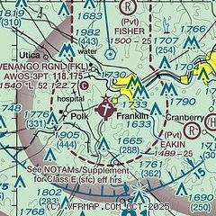
|
| Airport distance calculator |
|---|
|
|
| Sunrise and sunset |
|---|
|
Times for 08-Jun-2026
| | Local
(UTC-4) | | Zulu
(UTC) |
|---|
| Morning civil twilight | | 05:13 | | 09:13 |
| Sunrise | | 05:47 | | 09:47 |
| Sunset | | 20:50 | | 00:50 |
| Evening civil twilight | | 21:23 | | 01:23 |
|
| Current date and time |
|---|
| Zulu (UTC) | 08-Jun-2026 15:47:06 |
|---|
| Local (UTC-4) | 08-Jun-2026 11:47:06 |
|---|
|
| METAR |
|---|
| KFKL | 081456Z AUTO 17006KT 10SM CLR 23/15 A3022 RMK AO2 SLP226 T02330150 51004
|
|
| TAF |
|---|
| KFKL | 081138Z 0812/0912 11005KT P6SM SKC
|
|
| NOTAMs |
|---|
NOTAMs are issued by the DoD/FAA and will open in a separate window not controlled by AirNav.
|
|

