FAA INFORMATION EFFECTIVE 19 MARCH 2026
Location
| FAA Identifier: | FOA |
| Lat/Long: | 38-39-53.9648N 088-27-11.2033W
38-39.899413N 088-27.186722W
38.6649902,-88.4531120
(estimated) |
| Elevation: | 472.6 ft. / 144.0 m (surveyed) |
| Variation: | 01W (2000) |
| From city: | 2 miles E of FLORA, IL |
| Time zone: | UTC -5 (UTC -6 during Standard Time) |
| Zip code: | 62839 |
Airport Operations
| Airport use: | Open to the public |
| Activation date: | 01/1957 |
| Control tower: | no |
| ARTCC: | KANSAS CITY CENTER |
| FSS: | SAINT LOUIS FLIGHT SERVICE STATION |
| NOTAMs facility: | FOA (NOTAM-D service available) |
| Attendance: | MON-FRI 0800-1630 |
| Wind indicator: | lighted |
| Segmented circle: | no |
| Lights: | MIRL RY 03/21 PRESET ON LOW INTST; TO INCR INTST & ACTVT REIL RY 21; PLASI RYS 03/21 & TWY LGTS - CTAF. |
| Beacon: | white-green (lighted land airport)
Operates sunset to sunrise. |
Airport Communications
| CTAF/UNICOM: | 122.7 |
| WX AWOS-3: | 120.175 (618-662-8355) |
| WX AWOS-3 at OLY (13 nm E): | 119.275 (618-393-4416) |
| WX AWOS-3PT at FWC (17 nm S): | 119.425 (618-847-4709) |
- APCH/DEP SVC PRVDD BY KANSAS CITY ARTCC ON FREQS 127.7/351.825 (MOUNT VERNON RCAG)
Nearby radio navigation aids
| VOR radial/distance | | VOR name | | Freq | | Var |
|---|
| BIBr172/15.4 | | BIBLE GROVE VORTAC | | 109.00 | | 03E |
| ENLr062/36.2 | | CENTRALIA VORTAC | | 115.00 | | 04E |
| NDB name | | Hdg/Dist | | Freq | | Var | | ID |
|---|
| OLNEY | | 259/13.5 | | 272 | | 03W | | OLY | --- .-.. -.-- |
| WAYNE COUNTY | | 354/17.2 | | 257 | | 01W | | FWC | ..-. .-- -.-. |
Airport Services
| Fuel available: | 100LL JET-A
100LL:FUEL SELF SVC WITH CREDIT CARD. |
| Parking: | hangars and tiedowns |
| Airframe service: | NONE |
| Powerplant service: | NONE |
| Bottled oxygen: | NONE |
| Bulk oxygen: | NONE |
Runway Information
Runway 3/21
| Dimensions: | 5003 x 75 ft. / 1525 x 23 m |
| Surface: | asphalt, in fair condition |
| Weight bearing capacity: | | Single wheel: | 30.0 | | Double wheel: | 40.0 |
|
| Runway edge lights: | medium intensity |
| RUNWAY 3 | | RUNWAY 21 |
| Latitude: | 38-39.496723N | | 38-40.212957N |
| Longitude: | 088-27.425238W | | 088-26.905283W |
| Elevation: | 472.5 ft. | | 466.1 ft. |
| Traffic pattern: | left | | left |
| Runway heading: | 031 magnetic, 030 true | | 211 magnetic, 210 true |
| Markings: | nonprecision, in fair condition | | nonprecision, in fair condition |
| Visual slope indicator: | pulsating/steady burning VASI on left (3.00 degrees glide path) | | pulsating/steady burning VASI on left (3.00 degrees glide path) |
| Runway end identifier lights: | no | | yes |
| Touchdown point: | yes, no lights | | yes, no lights |
| Instrument approach: | | | LOC/DME |
| Obstructions: | 73 ft. tree, 2708 ft. from runway, 94 ft. right of centerline, 34:1 slope to clear | | 46 ft. tree, 1780 ft. from runway, 62 ft. left of centerline, 34:1 slope to clear |
Runway 15/33
| Dimensions: | 2715 x 100 ft. / 828 x 30 m |
| Surface: | turf, in good condition |
| Runway edge markings: | RWY 15 /33 THLDS & BOUNDARY OUTLINED BY WHITE 1/2 TIRES. DAY USE ONLY. |
| RUNWAY 15 | | RUNWAY 33 |
| Latitude: | 38-40.175065N | | 38-39.788030N |
| Longitude: | 088-27.369158W | | 088-27.083382W |
| Elevation: | 472.2 ft. | | 465.2 ft. |
| Traffic pattern: | left | | left |
| Runway heading: | 151 magnetic, 150 true | | 331 magnetic, 330 true |
| Displaced threshold: | 204 ft. | | 174 ft. |
| Runway end identifier lights: | no | | no |
| Touchdown point: | yes, no lights | | yes, no lights |
| Obstructions: | 46 ft. tree, 611 ft. from runway, 13:1 slope to clear
APCH SLOPE 17:1 TO DSPLCD THR. | | 27 ft. pline, 357 ft. from runway, 160 ft. right of centerline, 13:1 slope to clear |
Airport Ownership and Management from official FAA records
| Ownership: | Publicly-owned |
| Owner: | FLORA AIRPORT AUTHORITY
ONE AIRPORT ROAD
FLORA, IL 62839
Phone 618-662-2174 |
| Manager: | KAREN PICKEL
ONE AIRPORT ROAD
FLORA, IL 62839
Phone 618-662-2823 |
Additional Remarks
| - | RY 15/33 SOFT WHEN WET. |
| - | FOR CD CTC KANSAS CITY ARTCC AT 913-254-8508. |
Instrument Procedures
NOTE: All procedures below are presented as PDF files. If you need a reader for these files, you should download the free Adobe Reader.NOT FOR NAVIGATION. Please procure official charts for flight.
FAA instrument procedures published for use from 19 March 2026 at 0901Z to 16 April 2026 at 0900Z.
IAPs - Instrument Approach Procedures |
|---|
| RNAV (GPS) RWY 03 | |
download (251KB) |
| RNAV (GPS) RWY 21 | |
download (233KB) |
| LOC RWY 21 | |
download (200KB) |
| NOTE: Special Alternate Minimums apply | |
download (27KB) |
| NOTE: Special Take-Off Minimums/Departure Procedures apply | |
download (485KB) |
Other nearby airports with instrument procedures:
KOLY - Olney-Noble Airport (13 nm E)
KFWC - Fairfield Municipal Airport (17 nm S)
KSLO - Salem-Leckrone Airport (24 nm W)
1H2 - Effingham County Regional Airport (25 nm N)
KMVN - Mount Vernon Airport (28 nm SW)
|
|

Road maps at:
MapQuest
Bing
Google
| Aerial photo |
|---|
WARNING: Photo may not be current or correct
 Photo by David Newcomer
Photo taken 14-Dec-2017
from 4,500' looking south.
Photo by David Newcomer
Photo taken 14-Dec-2017
from 4,500' looking south.
Do you have a better or more recent aerial photo of Flora Municipal Airport that you would like to share? If so, please send us your photo.
|
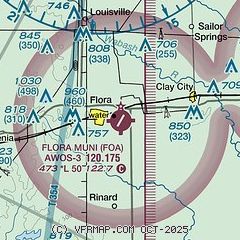
| Sectional chart |
|---|
|
| Airport distance calculator |
|---|
|
|
| Sunrise and sunset |
|---|
|
Times for 14-Apr-2026
| | Local
(UTC-5) | | Zulu
(UTC) |
|---|
| Morning civil twilight | | 05:53 | | 10:53 |
| Sunrise | | 06:20 | | 11:20 |
| Sunset | | 19:28 | | 00:28 |
| Evening civil twilight | | 19:56 | | 00:56 |
|
| Current date and time |
|---|
| Zulu (UTC) | 14-Apr-2026 12:33:17 |
|---|
| Local (UTC-5) | 14-Apr-2026 07:33:17 |
|---|
|
| METAR |
|---|
| KFOA | 141215Z AUTO 21013G17KT 10SM CLR 21/17 A2995 RMK AO2
|
KOLY
13nm E | 141210Z AUTO 20007KT 10SM CLR 21/17 A2996 RMK AO2 T02120170
|
KFWC
17nm S | 141215Z AUTO 21008G14KT 10SM BKN043 21/16 A2998 RMK AO2 T02100162
|
|
| TAF |
|---|
KMVN
29nm SW | 141120Z 1412/1512 21012KT P6SM SCT025 BKN035 FM141400 21014G22KT P6SM SCT050 FM150100 20008KT P6SM SCT250
|
|
| NOTAMs |
|---|
NOTAMs are issued by the DoD/FAA and will open in a separate window not controlled by AirNav.
|
|

