FAA INFORMATION EFFECTIVE 14 MAY 2026
Location
| FAA Identifier: | FSK |
| Lat/Long: | 37-47-54.1000N 094-46-09.7000W
37-47.901667N 094-46.161667W
37.7983611,-94.7693611
(estimated) |
| Elevation: | 918 ft. / 279.8 m (surveyed) |
| Variation: | 04E (1995) |
| From city: | 4 miles SW of FORT SCOTT, KS |
| Time zone: | UTC -5 (UTC -6 during Standard Time) |
| Zip code: | 66701 |
Airport Operations
| Airport use: | Open to the public |
| Activation date: | 04/1940 |
| Control tower: | no |
| ARTCC: | KANSAS CITY CENTER |
| FSS: | WICHITA FLIGHT SERVICE STATION |
| NOTAMs facility: | ICT (NOTAM-D service available) |
| Attendance: | MON-SAT 0800-1700 |
| Wind indicator: | lighted |
| Segmented circle: | yes |
| Lights: | ACTVT MIRL RY 18/36; VASI RY 18; PAPI RY 36 & REIL RYS 18 & 36 - CTAF. |
| Beacon: | white-green (lighted land airport)
Operates sunset to sunrise. |
Airport Communications
| CTAF/UNICOM: | 122.8 |
| WX AWOS-3P: | 124.425 (620-215-5899) |
- APCH/DEP CTL SVC PRVDD BY KANSAS CITY ARTCC (ZKC) ON FREQS 125.55/327.0 (BUTLER RCAG).
Nearby radio navigation aids
| VOR radial/distance | | VOR name | | Freq | | Var |
|---|
| BUMr198/31.4 | | BUTLER VORTAC | | 115.90 | | 07E |
Airport Services
| Fuel available: | 100LL JET-A1+ |
| Parking: | hangars and tiedowns |
| Airframe service: | NONE |
| Powerplant service: | NONE |
| Bottled oxygen: | NONE |
| Bulk oxygen: | NONE |
Runway Information
Runway 18/36
| Dimensions: | 4403 x 75 ft. / 1342 x 23 m |
| Surface: | asphalt, in good condition |
| Weight bearing capacity: | | PCN 9 /F/D/X/T | | Single wheel: | 24.0 |
|
| Runway edge lights: | medium intensity |
| RUNWAY 18 | | RUNWAY 36 |
| Latitude: | 37-48.264185N | | 37-47.538732N |
| Longitude: | 094-46.162418W | | 094-46.161323W |
| Elevation: | 903.2 ft. | | 918.0 ft. |
| Traffic pattern: | left | | left |
| Runway heading: | 176 magnetic, 180 true | | 356 magnetic, 360 true |
| Markings: | nonprecision, in fair condition | | nonprecision, in fair condition |
| Visual slope indicator: | 4-box VASI on left (3.00 degrees glide path) | | 2-light PAPI on left (3.00 degrees glide path) |
| Runway end identifier lights: | yes | | yes |
| Touchdown point: | yes, no lights | | yes, no lights |
| Obstructions: | 20 ft. trees, 250 ft. from runway, 215 ft. right of centerline, 2:1 slope to clear | | 55 ft. tree, 1403 ft. from runway, 220 ft. right of centerline, 21:1 slope to clear |
Airport Ownership and Management from official FAA records
| Ownership: | Publicly-owned |
| Owner: | CITY OF FORT SCOTT
123 SOUTH MAIN ST.
FORT SCOTT, KS 66701
Phone 620-223-0550 |
| Manager: | SETH SIMPSON
1869 INDIAN RD., P.O. BOX 151
FORT SCOTT, KS 66701
Phone 620-223-5490 |
Additional Remarks
| - | DEER FENCE AROUND AIRPORT PERIMETER. |
| - | GROUND DROPS RAPIDLY 250' FROM RWY 18 END. |
| - | FOR CD CTC KANSAS CITY ARTCC AT 913-254-8508. |
Instrument Procedures
NOTE: All procedures below are presented as PDF files. If you need a reader for these files, you should download the free Adobe Reader.NOT FOR NAVIGATION. Please procure official charts for flight.
FAA instrument procedures published for use from 14 May 2026 at 0901Z to 11 June 2026 at 0900Z.
IAPs - Instrument Approach Procedures |
|---|
| RNAV (GPS) RWY 18 | |
download (233KB) |
| RNAV (GPS) RWY 36 | |
download (240KB) |
| NOTE: Special Take-Off Minimums/Departure Procedures apply | |
download (147KB) |
Other nearby airports with instrument procedures:
KPTS - Atkinson Municipal Airport (21 nm S)
KNVD - Nevada Municipal Airport (22 nm E)
KLLU - Lamar Municipal Airport (29 nm SE)
K88 - Allen County Airport (30 nm W)
KCNU - Chanute Martin Johnson Airport (35 nm W)
|
|

Road maps at:
MapQuest
Bing
Google
| Aerial photo |
|---|
WARNING: Photo may not be current or correct
 Photo by Eve Cascella
Photo taken 22-Sep-2013
looking north.
Photo by Eve Cascella
Photo taken 22-Sep-2013
looking north.
Do you have a better or more recent aerial photo of Fort Scott Municipal Airport that you would like to share? If so, please send us your photo.
|
| Sectional chart |
|---|
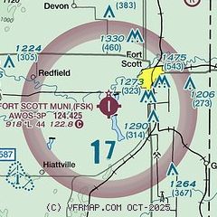
|
| Airport distance calculator |
|---|
|
|
| Sunrise and sunset |
|---|
|
Times for 22-May-2026
| | Local
(UTC-5) | | Zulu
(UTC) |
|---|
| Morning civil twilight | | 05:35 | | 10:35 |
| Sunrise | | 06:05 | | 11:05 |
| Sunset | | 20:27 | | 01:27 |
| Evening civil twilight | | 20:57 | | 01:57 |
|
| Current date and time |
|---|
| Zulu (UTC) | 22-May-2026 07:51:08 |
|---|
| Local (UTC-5) | 22-May-2026 02:51:08 |
|---|
|
| METAR |
|---|
| KFSK | 220735Z AUTO 04003KT 10SM OVC120 16/16 A2994 RMK AO2 T01650164
|
|
| TAF |
|---|
KCNU
35nm W | 220520Z 2206/2306 11006KT 6SM BR VCSH SCT004 BKN009 TEMPO 2209/2212 OVC004 FM221800 13006KT P6SM SCT009 BKN015 FM222100 12005KT P6SM BKN035
|
KJLN
41nm S | 220529Z 2206/2306 VRB04KT P6SM -SHRA OVC060 FM220900 VRB04KT P6SM -SHRA OVC015 FM222000 VRB04KT P6SM BKN021 FM230000 VRB05KT P6SM SCT100
|
|
| NOTAMs |
|---|
NOTAMs are issued by the DoD/FAA and will open in a separate window not controlled by AirNav.
|
|

