FAA INFORMATION EFFECTIVE 09 JULY 2026
Location
| FAA Identifier: | GPI |
| Lat/Long: | 48-18-37.8000N 114-15-21.6000W
48-18.630000N 114-15.360000W
48.3105000,-114.2560000
(estimated) |
| Elevation: | 2976.8 ft. / 907.3 m (surveyed) |
| Variation: | 15E (2010) |
| From city: | 6 miles NE of KALISPELL, MT |
| Time zone: | UTC -6 (UTC -7 during Standard Time) |
| Zip code: | 59901 |
Airport Operations
| Airport use: | Open to the public |
| Activation date: | 02/1944 |
| Control tower: | yes |
| ARTCC: | SALT LAKE CITY CENTER |
| FSS: | GREAT FALLS FLIGHT SERVICE STATION |
| NOTAMs facility: | GPI (NOTAM-D service available) |
| Attendance: | CONTINUOUS |
| Wind indicator: | lighted |
| Segmented circle: | yes |
| Lights: | ACTVT MALSR RWY 02; REIL RWY 20; HIRL RWY 02/20; MIRL RWY 12/30 - CTAF. PAPI RWY 02, 20 & 30 OPR CONSLY. |
| Beacon: | white-green (lighted land airport)
Operates sunset to sunrise. |
| Landing fee: | yes |
| Fire and rescue: | ARFF index C |
| Airline operations: | CLSD TO UNSKED ACR OPS MORE THAN 30 PAX SEATS EXC PPR - AMGR. |
| International operations: | customs landing rights airport |
Airport Communications
| CTAF: | 124.55 |
| UNICOM: | 122.95 |
| ATIS: | 132.625 |
| WX ASOS: | 132.625 (406-233-0175) |
| GLACIER GROUND: | 121.6 [0800-0000] |
| GLACIER TOWER: | 124.55 [0800-0000] |
- APCH/DEP CTL SVC PRVDD BY SALT LAKE ARTCC (ZLC) ON FREQS 127.075/244.875 (LAKESIDE RCAG).
- COMMUNICATIONS PRVDD BY GREAT FALLS RADIO ON FREQ 122.5 (LAKESIDE RCO).
Nearby radio navigation aids
| VOR radial/distance | | VOR name | | Freq | | Var |
|---|
| FCAr313/6.6 | | KALISPELL VOR/DME | | 113.20 | | 18E |
| NDB name | | Hdg/Dist | | Freq | | Var | | ID |
|---|
| SMITH LAKE | | 019/14.6 | | 515 | | 15E | | SAK | ... .- -.- |
Airport Services
| Fuel available: | 100LL JET-A |
| Parking: | hangars and tiedowns |
| Airframe service: | MAJOR |
| Powerplant service: | MAJOR |
| Bulk oxygen: | HIGH/LOW |
Runway Information
Runway 2/20
| Dimensions: | 9007 x 150 ft. / 2745 x 46 m |
| Surface: | asphalt/grooved, in good condition |
| Weight bearing capacity: | | Single wheel: | 115.0 | | Double wheel: | 198.0 | | Double tandem: | 321.0 |
|
| Runway edge lights: | high intensity |
| RUNWAY 2 | | RUNWAY 20 |
| Latitude: | 48-17.928002N | | 48-19.143777N |
| Longitude: | 114-16.059173W | | 114-14.790908W |
| Elevation: | 2962.3 ft. | | 2976.7 ft. |
| Traffic pattern: | left | | left |
| Runway heading: | 020 magnetic, 035 true | | 200 magnetic, 215 true |
| Declared distances: | TORA:9007 TODA:9007 ASDA:9007 LDA:9007 | | TORA:9007 TODA:9007 ASDA:9007 LDA:9007 |
| Markings: | precision, in good condition | | precision, in good condition |
| Visual slope indicator: | 4-light PAPI on left (3.00 degrees glide path) | | 4-light PAPI on left (3.00 degrees glide path) |
| Approach lights: | MALSR: 1,400 foot medium intensity approach lighting system with runway alignment indicator lights | | |
| Runway end identifier lights: | | | yes |
| Touchdown point: | yes, no lights | | yes, no lights |
| Instrument approach: | ILS | | |
Runway 12/30
| Dimensions: | 3510 x 75 ft. / 1070 x 23 m |
| Surface: | asphalt/grooved, in good condition |
| Weight bearing capacity: | | Single wheel: | 25.0 | | Double wheel: | 40.0 |
|
| Runway edge lights: | medium intensity |
| RUNWAY 12 | | RUNWAY 30 |
| Latitude: | 48-19.077193N | | 48-18.660090N |
| Longitude: | 114-15.490005W | | 114-14.891920W |
| Elevation: | 2972.9 ft. | | 2971.4 ft. |
| Traffic pattern: | left | | left |
| Runway heading: | 121 magnetic, 136 true | | 301 magnetic, 316 true |
| Declared distances: | TORA:3510 TODA:3510 ASDA:3510 LDA:3510 | | TORA:3510 TODA:3510 ASDA:3510 LDA:3510 |
| Markings: | nonprecision, in good condition | | nonprecision, in good condition |
| Visual slope indicator: | | | 2-light PAPI on left (3.50 degrees glide path) |
| Touchdown point: | yes, no lights | | yes, no lights |
Airport Ownership and Management from official FAA records
| Ownership: | Publicly-owned |
| Owner: | FLATHEAD MUNI ARPT AUTHORITY
4170 HWY 2
KALISPELL, MT 59901
Phone 406-257-5994 |
| Manager: | ROB RATKOWSKI
4170 HWY 2
KALISPELL, MT 59901
Phone 406-257-5994 |
Additional Remarks
| A39-12/30 | PCR VALUE: 80/F/C/X/T |
| A39-02/20 | PCR VALUE: 513/F/B/X/T |
| - | COLD TEMPERATURE AIRPORT. ALTITUDE CORRECTION REQUIRED AT OR BELOW -14C. |
| - | CTN: SKYDIVING OPS 6 NM NW 13000 FT & BLW SR-SS JUN-SEP. PAJA STATUS - SALT LAKE ARTCC. |
| - | CTN: VFR TFC OPS AT KALISPELL CITY ARPT 8 NM S & WHITEFISH ARPT 6 NM NW. |
| - | ARFF INDEX C FOR SKED INDEX C ACR OPS; OTHERWISE, ARFF INDEX B EXC 30 MIN PPR. |
Instrument Procedures
NOTE: All procedures below are presented as PDF files. If you need a reader for these files, you should download the free Adobe Reader.NOT FOR NAVIGATION. Please procure official charts for flight.
FAA instrument procedures published for use from 09 July 2026 at 0901Z to 06 August 2026 at 0900Z.
IAPs - Instrument Approach Procedures |
|---|
| ILS OR LOC RWY 02 | |
download (465KB) |
| RNAV (RNP) RWY 20 | |
download (450KB) |
| RNAV (RNP) Y RWY 02 | |
download (655KB) |
| RNAV (GPS) RWY 30 | |
download (421KB) |
| RNAV (GPS) Z RWY 02 | |
download (408KB) |
| VOR/DME RWY 30 | |
download (477KB) |
| NOTE: Special Alternate Minimums apply | |
download (211KB) |
Departure Procedures |
|---|
| RIDDG TWO (RNAV) | |
download (236KB) |
|
|---|
| SKOTT TWO (OBSTACLE) | |
download (323KB) |
| NOTE: Special Take-Off Minimums/Departure Procedures apply | |
download (223KB) |
Other nearby airports with instrument procedures:
8S1 - Polson Airport (37 nm S)
7S0 - Ronan Airport (45 nm S)
S59 - Libby Airport (49 nm W)
KCTB - Cut Bank International Airport (77 nm E)
KMSO - Missoula Montana Airport (84 nm S)
|
|

Road maps at:
MapQuest
Bing
Google
| Aerial photo |
|---|
WARNING: Photo may not be current or correct
 Photo courtesy of Frank Leff at NavMonster
Photo taken 31-Aug-2009
Photo courtesy of Frank Leff at NavMonster
Photo taken 31-Aug-2009
Do you have a better or more recent aerial photo of Glacier Park International Airport that you would like to share? If so, please send us your photo.
|
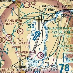
| Sectional chart |
|---|
|
 Download PDF
of official airport diagram from the FAA
| Airport distance calculator |
|---|
|
|
| Sunrise and sunset |
|---|
|
Times for 09-Jul-2026
| | Local
(UTC-6) | | Zulu
(UTC) |
|---|
| Morning civil twilight | | 05:07 | | 11:07 |
| Sunrise | | 05:47 | | 11:47 |
| Sunset | | 21:37 | | 03:37 |
| Evening civil twilight | | 22:18 | | 04:18 |
|
| Current date and time |
|---|
| Zulu (UTC) | 09-Jul-2026 08:27:07 |
|---|
| Local (UTC-6) | 09-Jul-2026 02:27:07 |
|---|
|
| METAR |
|---|
| KGPI | 090755Z AUTO 00000KT 10SM CLR 13/08 A2999 RMK AO2 SLP140 T01330078 PWINO $
|
|
| TAF |
|---|
| KGPI | 090520Z 0906/1006 VRB03KT P6SM SKC FM091700 19009KT P6SM SCT200 FM092200 20011G22KT P6SM SCT200 FM100200 VRB03KT P6SM SKC
|
|
| NOTAMs |
|---|
NOTAMs are issued by the DoD/FAA and will open in a separate window not controlled by AirNav.
|
|


