FAA INFORMATION EFFECTIVE 07 AUGUST 2025
Location
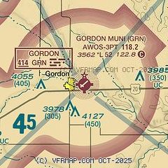
| FAA Identifier: | GRN |
| Lat/Long: | 42-48-21.5210N 102-10-30.9040W
42-48.358683N 102-10.515067W
42.8059781,-102.1752511
(estimated) |
| Elevation: | 3562.1 ft. / 1085.7 m (surveyed) |
| Variation: | 09E (2000) |
| From city: | 1 mile E of GORDON, NE |
| Time zone: | UTC -6 (UTC -7 during Standard Time) |
| Zip code: | 69343 |
Airport Operations
| Airport use: | Open to the public |
| Activation date: | 02/1946 |
| Control tower: | no |
| ARTCC: | DENVER CENTER |
| FSS: | COLUMBUS FLIGHT SERVICE STATION |
| NOTAMs facility: | OLU (NOTAM-D service available) |
| Attendance: | MON-FRI 0800-1700
FOR SVC AFTER HRS CALL 308-360-1906 OR 308-360-2120. |
| Wind indicator: | lighted |
| Segmented circle: | no |
| Lights: | ACTVT REIL RWY 04 & 22; MIRL RWY 4/22 & 11/29 - CTAF. PAPI RWY 04 & 22 OPR CONSLY. |
| Beacon: | white-green (lighted land airport)
Operates sunset to sunrise. |
Airport Communications
| CTAF/UNICOM: | 122.8 |
| WX AWOS-3PT: | 118.2 (308-282-0127) |
| WX ASOS at IEN (19 nm NW): | 126.775 (605-867-1584) |
- APCH/DEP CTL SVC PRVDD BY DENVER ARTCC (ZDV) ON FREQS 127.95/338.2 (CRAWFORD RCAG).
Nearby radio navigation aids
| NDB name | | Hdg/Dist | | Freq | | Var | | ID |
|---|
| GORDON | | at field | | 414 | | 09E | | GRN | --. .-. -. |
Airport Services
| Fuel available: | 100LL
100LL:AVGAS AVBL. |
| Parking: | hangars and tiedowns |
| Bottled oxygen: | NONE |
| Bulk oxygen: | NONE |
Runway Information
Runway 4/22
| Dimensions: | 5196 x 75 ft. / 1584 x 23 m |
| Surface: | asphalt, in good condition |
| Weight bearing capacity: | |
| Runway edge lights: | medium intensity |
| RUNWAY 4 | | RUNWAY 22 |
| Latitude: | 42-48.119925N | | 42-48.684158N |
| Longitude: | 102-10.869933W | | 102-09.997118W |
| Elevation: | 3543.5 ft. | | 3562.1 ft. |
| Traffic pattern: | left | | left |
| Runway heading: | 040 magnetic, 049 true | | 220 magnetic, 229 true |
| Markings: | nonprecision, in good condition | | nonprecision, in good condition |
| Visual slope indicator: | 2-light PAPI on left (3.00 degrees glide path) | | 2-light PAPI on left (3.00 degrees glide path) |
| Runway end identifier lights: | yes | | yes |
| Touchdown point: | yes, no lights | | yes, no lights |
| Obstructions: | 57 ft. trees, 1213 ft. from runway, 197 ft. right of centerline, 17:1 slope to clear | | 21 ft. road, 673 ft. from runway, 22:1 slope to clear |
Runway 11/29
| Dimensions: | 2284 x 50 ft. / 696 x 15 m |
| Surface: | asphalt, in poor condition
WEEDS IN PAVEMENT; MED & HIGH SEVERITY CRACKS IN PAVEMENT. |
| Weight bearing capacity: | |
| Runway edge lights: | medium intensity |
| Operational restrictions: | MARKINGS FADED. |
| RUNWAY 11 | | RUNWAY 29 |
| Latitude: | 42-48.361630N | | 42-48.158377N |
| Longitude: | 102-10.915265W | | 102-10.485737W |
| Elevation: | 3548.9 ft. | | 3542.1 ft. |
| Traffic pattern: | left | | left |
| Runway heading: | 114 magnetic, 123 true | | 294 magnetic, 303 true |
| Markings: | basic, in fair condition | | basic, in fair condition |
| Touchdown point: | yes, no lights | | yes, no lights |
| Obstructions: | 15 ft. road, 433 ft. from runway, 15:1 slope to clear | | 3 ft. fence, 222 ft. from runway, 127 ft. right of centerline, 7:1 slope to clear |
Airport Ownership and Management from official FAA records
| Ownership: | Publicly-owned |
| Owner: | GORDON ARPT AUTH
PO BOX 310
GORDON, NE 69343-0310
Phone 308-282-0837
MARK KRUGER (605) 840-0177. |
| Manager: | GLEN SPAUGH
PO BOX 310
GORDON, NE 69343-0310
Phone 308-282-0837 |
Additional Remarks
| - | FOR CD CTC DENVER ARTCC AT 303-651-4257. |
Instrument Procedures
NOTE: All procedures below are presented as PDF files. If you need a reader for these files, you should download the free Adobe Reader.NOT FOR NAVIGATION. Please procure official charts for flight.
FAA instrument procedures published for use from 07 August 2025 at 0901Z to 04 September 2025 at 0900z.
IAPs - Instrument Approach Procedures |
|---|
| RNAV (GPS) RWY 04 **CHANGED** | |
download (199KB) |
| RNAV (GPS) RWY 22 **CHANGED** | |
download (213KB) |
| NDB RWY 22 **CHANGED** | |
download (175KB) |
| NOTE: Special Alternate Minimums apply | |
download (55KB) |
| NOTE: Special Take-Off Minimums/Departure Procedures apply | |
download (147KB) |
Other nearby airports with instrument procedures:
9V5 - Modisett Airport (13 nm W)
KIEN - Pine Ridge Airport (19 nm NW)
9V6 - Martin Municipal Airport (30 nm NE)
KCDR - Chadron Municipal Airport (41 nm W)
KAIA - Alliance Municipal Airport (53 nm SW)
|
|

Road maps at:
MapQuest
Bing
Google
| Aerial photo |
|---|
WARNING: Photo may not be current or correct
 Photo by P.J. Reinders
Taken in September 2008
Photo by P.J. Reinders
Taken in September 2008
Do you have a better or more recent aerial photo of Gordon Municipal Airport that you would like to share? If so, please send us your photo.
|
| Sectional chart |
|---|
|
| Airport distance calculator |
|---|
|
|
| Sunrise and sunset |
|---|
|
Times for 14-Aug-2025
| | Local
(UTC-6) | | Zulu
(UTC) |
|---|
| Morning civil twilight | | 05:24 | | 11:24 |
| Sunrise | | 05:55 | | 11:55 |
| Sunset | | 19:52 | | 01:52 |
| Evening civil twilight | | 20:22 | | 02:22 |
|
| Current date and time |
|---|
| Zulu (UTC) | 14-Aug-2025 17:31:26 |
|---|
| Local (UTC-6) | 14-Aug-2025 11:31:26 |
|---|
|
| METAR |
|---|
| KGRN | 141715Z AUTO 00000KT 10SM CLR 30/18 A2989 RMK AO2 T02970177
|
|
| TAF |
|---|
KCDR
41nm W | 141120Z 1412/1512 24005KT P6SM SCT120 FM141900 32009G19KT P6SM SCT100 FM150000 04008KT P6SM SCT120 BKN150
|
|
| NOTAMs |
|---|
NOTAMs are issued by the DoD/FAA and will open in a separate window not controlled by AirNav.
|
|

