FAA INFORMATION EFFECTIVE 14 MAY 2026
Location
| FAA Identifier: | GTF |
| Lat/Long: | 47-28-56.2774N 111-22-13.0059W
47-28.937957N 111-22.216765W
47.4822993,-111.3702794
(estimated) |
| Elevation: | 3680 ft. / 1121.7 m (surveyed) |
| Variation: | 13E (2020) |
| From city: | 3 miles SW of GREAT FALLS, MT |
| Time zone: | UTC -6 (UTC -7 during Standard Time) |
| Zip code: | 59404 |
Airport Operations
| Airport use: | Open to the public |
| Activation date: | 04/1940 |
| Control tower: | yes |
| ARTCC: | SALT LAKE CITY CENTER |
| FSS: | GREAT FALLS FLIGHT SERVICE STATION |
| NOTAMs facility: | GTF (NOTAM-D service available) |
| Attendance: | CONTINUOUS |
| Wind indicator: | yes |
| Segmented circle: | yes |
| Lights: | REIL RWY 21 OPR CONSLY WHEN RWY LGTS ARE ON. RWY LGTS CTLD BY TWR. |
| Beacon: | white-green (lighted land airport)
Operates sunset to sunrise. |
| Fire and rescue: | ARFF index B |
| Airline operations: | INDEX LEVEL C ARFF CAPABILITY IS AVBL AT ALL TIMES. |
| International operations: | international airport of entry |
Airport Communications
| UNICOM: | 122.95 |
| ATIS: | 126.6 269.0 |
| WX ASOS: | 126.6 (406-454-7551) |
| GREAT FALLS GROUND: | 121.7 348.6 |
| GREAT FALLS TOWER: | 118.7 282.2 |
| GREAT FALLS APPROACH: | 128.6 379.175 290.3 380.3 |
| GREAT FALLS DEPARTURE: | 128.6 379.175 290.3 380.3 |
| CLEARANCE DELIVERY: | 121.7 348.6 |
| EMERG: | 121.5 243.0 |
| TRSA: | 128.6 379.175 |
Nearby radio navigation aids
| VOR radial/distance | | VOR name | | Freq | | Var |
|---|
| GTFr025/2.6 | | GREAT FALLS VORTAC | | 115.10 | | 16E |
Airport Services
| Fuel available: | 100LL JET-A |
| Parking: | hangars and tiedowns |
| Airframe service: | MAJOR |
| Powerplant service: | MAJOR |
| Bottled oxygen: | HIGH/LOW |
| Bulk oxygen: | HIGH/LOW |
Runway Information
Runway 3/21
| Dimensions: | 10502 x 150 ft. / 3201 x 46 m |
| Surface: | asphalt/grooved, in good condition |
| Weight bearing capacity: | | Single wheel: | 116.0 | | Double wheel: | 225.0 | | Double tandem: | 424.0 | | Dual double tandem: | 915.0, FOR DC-10-40 AND B747. |
|
| Runway edge lights: | high intensity |
| RUNWAY 3 | | RUNWAY 21 |
| Latitude: | 47-28.160583N | | 47-29.381565N |
| Longitude: | 111-23.029772W | | 111-21.227725W |
| Elevation: | 3680.0 ft. | | 3659.3 ft. |
| Traffic pattern: | left | | left |
| Runway heading: | 032 magnetic, 045 true | | 212 magnetic, 225 true |
| Declared distances: | TORA:10502 TODA:10502 ASDA:10502 LDA:10502 | | TORA:10502 TODA:10502 ASDA:10502 LDA:10502 |
| Markings: | precision, in good condition | | precision, in good condition |
| Visual slope indicator: | 4-light PAPI on left (3.00 degrees glide path)
PAPI UNUSBL BYD 9 DEGS RIGHT OF CNTRLN. | | 4-light PAPI on right (3.00 degrees glide path) |
| RVR equipment: | touchdown, midfield, rollout | | touchdown, midfield, rollout |
| Approach lights: | ALSF2: standard 2,400 foot high intensity approach lighting system with centerline sequenced flashers (category II or III) | | |
| Runway end identifier lights: | | | yes |
| Centerline lights: | yes | | yes |
| Touchdown point: | yes, lighted | | yes, no lights |
| Instrument approach: | ILS/DME | | |
| Obstructions: | 25 ft. road, 1300 ft. from runway, 645 ft. right of centerline, 43:1 slope to clear | | none |
Runway 17/35
| Dimensions: | 6030 x 150 ft. / 1838 x 46 m |
| Surface: | asphalt/grooved, in good condition |
| Weight bearing capacity: | | Single wheel: | 87.0 | | Double wheel: | 140.0 | | Double tandem: | 245.0 | | Dual double tandem: | 245.0 |
|
| Runway edge lights: | medium intensity |
| RUNWAY 17 | | RUNWAY 35 |
| Latitude: | 47-29.724462N | | 47-28.732762N |
| Longitude: | 111-22.369817W | | 111-22.370293W |
| Elevation: | 3640.2 ft. | | 3667.9 ft. |
| Traffic pattern: | left | | left |
| Runway heading: | 167 magnetic, 180 true | | 347 magnetic, 360 true |
| Displaced threshold: | 230 ft. | | no |
| Declared distances: | TORA:6030 TODA:6030 ASDA:6030 LDA:5800 | | TORA:5400 TODA:5400 ASDA:5400 LDA:5400 |
| Markings: | nonprecision, in good condition | | nonprecision, in good condition |
| Visual slope indicator: | 4-light PAPI on left (3.00 degrees glide path) | | 4-light PAPI on left (3.00 degrees glide path) |
| Touchdown point: | yes, no lights | | yes, no lights |
| Obstructions: | 10 ft. road, 345 ft. from runway, 266 ft. left of centerline, 14:1 slope to clear | | none |
Airport Ownership and Management from official FAA records
| Ownership: | Publicly-owned |
| Owner: | GREAT FALLS INTL ARPT AUTH
2800 TERMINAL DR
GREAT FALLS, MT 59404-5599
Phone 406-727-3404 |
| Manager: | JOHN FAULKNER
2800 TERMINAL DRIVE
GREAT FALLS, MT 59404-5599
Phone 406-727-3404 |
Additional Remarks
| A39-03/21 | PCR VALUE: 5290/F/B/X/T |
| A39-17/35 | PCR VALUE: 300/F/B/X/U |
| - | TWY C UNRSTD WT AND AVBL FOR TAXIING ACFT. |
| - | MILITARY: ANG: OPR 1400-2330Z++ MON-THU, LTD FRI, CLOSED SAT-SUN AND HOL. BASE OPS DSN 791-0192, C406-791-0192. NO TRAN SVC SAT, SUN, HOL OR AFTER 2300Z++ MON-FRI. ACFT RQR ASSISTANCE CTC 288.9. RCR INFO AVBL FR BASE OPS. |
| - | MILITARY: ANG: LTD TRAN SVC ONLY AVBL FOR ACFT PARTICIPATING IN ANG OPS WITH PRIOR COORDINATION (PPR). |
| - | BIRDS ON AND INVOF ARPT. |
| - | MILITARY: ANG: USAF BASH - EXP INCREASED MIGRATORY WATERFOWL ACT (PHASE II) MAR-MAY AND SEP-DEC, SR-.5 TO SS+.5. |
| - | MILITARY: ANG: NSTD WHITE EQPT TOOL BOX LCTN PAINTED ON RAMP. |
| - | MILITARY: ANG: FUEL: A++ AVBL AT ANG. |
Instrument Procedures
NOTE: All procedures below are presented as PDF files. If you need a reader for these files, you should download the free Adobe Reader.NOT FOR NAVIGATION. Please procure official charts for flight.
FAA instrument procedures published for use from 14 May 2026 at 0901Z to 11 June 2026 at 0900Z.
IAPs - Instrument Approach Procedures |
|---|
| ILS OR LOC RWY 03 | |
download (258KB) |
| ILS RWY 03 (SA CAT I) | |
download (251KB) |
| ILS RWY 03 (CAT II - III) | |
download (265KB) |
| RNAV (RNP) Z RWY 03 | |
download (320KB) |
| RNAV (RNP) Z RWY 21 | |
download (304KB) |
| RNAV (GPS) RWY 17 | |
download (216KB) |
| RNAV (GPS) RWY 35 | |
download (224KB) |
| RNAV (GPS) Y RWY 03 | |
download (260KB) |
| RNAV (GPS) Y RWY 21 | |
download (251KB) |
| VOR RWY 03 | |
download (224KB) |
| VOR RWY 21 | |
download (208KB) |
| NOTE: Special Alternate Minimums apply | |
download |
| NOTE: Special Take-Off Minimums/Departure Procedures apply | |
download (422KB) |
Other nearby airports with instrument procedures:
79S - Fort Benton Airport (37 nm NE)
KCII - Choteau Airport (38 nm NW)
S01 - Conrad Airport (48 nm NW)
S64 - Stanford Airport/Biggerstaff Field (51 nm SE)
KHLN - Helena Regional Airport (58 nm SW)
|
|

Road maps at:
MapQuest
Bing
Google
| Aerial photo |
|---|
WARNING: Photo may not be current or correct

Do you have a better or more recent aerial photo of Great Falls International Airport that you would like to share? If so, please send us your photo.
|
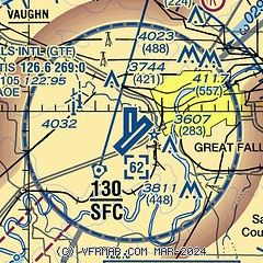
| Sectional chart |
|---|
|
CAUTION: Diagram may not be current
 Download PDF
of official airport diagram from the FAA
| Airport distance calculator |
|---|
|
|
| Sunrise and sunset |
|---|
|
Times for 18-May-2026
| | Local
(UTC-6) | | Zulu
(UTC) |
|---|
| Morning civil twilight | | 05:09 | | 11:09 |
| Sunrise | | 05:46 | | 11:46 |
| Sunset | | 20:58 | | 02:58 |
| Evening civil twilight | | 21:35 | | 03:35 |
|
| Current date and time |
|---|
| Zulu (UTC) | 19-May-2026 00:24:17 |
|---|
| Local (UTC-6) | 18-May-2026 18:24:17 |
|---|
|
| METAR |
|---|
| KGTF | 182353Z 16009KT 10SM BKN060 BKN080 11/M02 A3012 RMK AO2 SLP219 T01111022 10117 20078 58008 $
|
KGFA
8nm E | 182255Z AUTO 14004KT 10SM FEW090 12/M02 A3012 RMK AO2 SLP219 T01181021 $
|
|
| TAF |
|---|
| KGTF | 181720Z 1818/1918 VRB06KT P6SM BKN040 FM190600 21009KT P6SM FEW200
|
|
| NOTAMs |
|---|
NOTAMs are issued by the DoD/FAA and will open in a separate window not controlled by AirNav.
|
|


