FAA INFORMATION EFFECTIVE 19 MARCH 2026
Location
| FAA Identifier: | S01 |
| Lat/Long: | 48-10-05.8000N 111-58-35.2000W
48-10.096667N 111-58.586667W
48.1682778,-111.9764444
(estimated) |
| Elevation: | 3547.9 ft. / 1081.4 m (surveyed) |
| Variation: | 12E (2020) |
| From city: | 1 mile W of CONRAD, MT |
| Time zone: | UTC -6 (UTC -7 during Standard Time) |
| Zip code: | 59425 |
Airport Operations
| Airport use: | Open to the public |
| Activation date: | 11/1945 |
| Control tower: | no |
| ARTCC: | SALT LAKE CITY CENTER |
| FSS: | GREAT FALLS FLIGHT SERVICE STATION |
| NOTAMs facility: | GTF (NOTAM-D service available) |
| Attendance: | UNATTND |
| Wind indicator: | lighted |
| Segmented circle: | yes |
| Lights: | ACTVT REIL RWY 24; PAPI RWY 06/24; MIRL RWY 06/24 - CTAF. |
| Beacon: | white-green (lighted land airport)
Operates sunset to sunrise. |
Airport Communications
- AUTOMATED UNICOM.
- APCH/DEP CTL SVC PRVDD BY SALT LAKE CITY ARTCC ( ZLC) ON FREQS 133.4/285.4 (GREAT FALLS RCAG).
- COMMUNICATIONS PRVDD BY GREAT FALLS RADIO ON FREQ 122.2 (CUT BANK RCO).
Nearby radio navigation aids
| VOR radial/distance | | VOR name | | Freq | | Var |
|---|
| CTBr131/27.9 | | CUT BANK VOR/DME | | 113.35 | | 17E |
Airport Services
| Fuel available: | 100LL
100LL:100LL 24/7 SELF SVC. |
| Parking: | hangars and tiedowns |
Runway Information
Runway 6/24
| Dimensions: | 4602 x 75 ft. / 1403 x 23 m |
| Surface: | asphalt, in excellent condition |
| Weight bearing capacity: | | Single wheel: | 18.0 | | Double wheel: | 24.0 |
|
| Runway edge lights: | medium intensity |
| RUNWAY 6 | | RUNWAY 24 |
| Latitude: | 48-09.976792N | | 48-10.232413N |
| Longitude: | 111-59.138983W | | 111-58.074162W |
| Elevation: | 3547.9 ft. | | 3528.1 ft. |
| Traffic pattern: | left | | left |
| Runway heading: | 058 magnetic, 070 true | | 238 magnetic, 250 true |
| Markings: | nonprecision, in good condition | | nonprecision, in good condition |
| Visual slope indicator: | 2-light PAPI on left (3.00 degrees glide path) | | 2-light PAPI on left (3.00 degrees glide path) |
| Runway end identifier lights: | | | yes |
| Touchdown point: | yes, no lights | | yes, no lights |
| Obstructions: | 54 ft. pline, 1667 ft. from runway, 27:1 slope to clear | | none |
Runway 15/33
| Dimensions: | 2800 x 100 ft. / 853 x 30 m |
| Surface: | turf, in poor condition |
| RUNWAY 15 | | RUNWAY 33 |
| Latitude: | 48-10.302900N | | 48-09.862943N |
| Longitude: | 111-58.653165W | | 111-58.449995W |
| Elevation: | 3529.6 ft. | | 3539.6 ft. |
| Traffic pattern: | left | | left |
| Runway heading: | 151 magnetic, 163 true | | 331 magnetic, 343 true |
| Markings: | none | | none |
| Touchdown point: | yes, no lights | | yes, no lights |
Airport Ownership and Management from official FAA records
| Ownership: | Publicly-owned |
| Owner: | PONDERA COUNTY
20 4TH SW
CONRAD, MT 59425
Phone (406) 271-4011 |
| Manager: | HEATH ELINGS
111 GARLAND STREET
KALISPELL, MT 59901
Phone (406) 450-1620 |
Additional Remarks
| - | TWYS HAVE REFLECTORS |
| - | FOR CD CTC SALT LAKE ARTCC AT 801-320-2568. |
Instrument Procedures
NOTE: All procedures below are presented as PDF files. If you need a reader for these files, you should download the free Adobe Reader.NOT FOR NAVIGATION. Please procure official charts for flight.
FAA instrument procedures published for use from 19 March 2026 at 0901Z to 16 April 2026 at 0900Z.
IAPs - Instrument Approach Procedures |
|---|
| RNAV (GPS) RWY 06 **CHANGED** | |
download (224KB) |
| RNAV (GPS) RWY 24 **CHANGED** | |
download (233KB) |
| NOTE: Special Take-Off Minimums/Departure Procedures apply | |
download (459KB) |
Other nearby airports with instrument procedures:
KCII - Choteau Airport (22 nm S)
KSBX - Shelby Airport (23 nm N)
KCTB - Cut Bank International Airport (31 nm NW)
KGTF - Great Falls International Airport (48 nm SE)
79S - Fort Benton Airport (57 nm E)
|
|

Road maps at:
MapQuest
Bing
Google
| Aerial photo |
|---|

|
| Sectional chart |
|---|
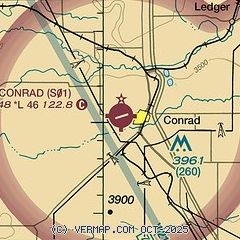
|
| Airport distance calculator |
|---|
|
|
| Sunrise and sunset |
|---|
|
Times for 25-Mar-2026
| | Local
(UTC-6) | | Zulu
(UTC) |
|---|
| Morning civil twilight | | 06:50 | | 12:50 |
| Sunrise | | 07:21 | | 13:21 |
| Sunset | | 19:47 | | 01:47 |
| Evening civil twilight | | 20:18 | | 02:18 |
|
| Current date and time |
|---|
| Zulu (UTC) | 25-Mar-2026 11:42:59 |
|---|
| Local (UTC-6) | 25-Mar-2026 05:42:59 |
|---|
|
| TAF |
|---|
KCTB
30nm NW | 250918Z 2509/2606 25022G35KT P6SM SCT070 BKN120 FM251200 26028G41KT P6SM SCT120 FM251700 26035G50KT P6SM SCT120 FM260000 31015G25KT P6SM SCT080 BKN120
|
|
| NOTAMs |
|---|
NOTAMs are issued by the DoD/FAA and will open in a separate window not controlled by AirNav.
|
|

