FAA INFORMATION EFFECTIVE 14 MAY 2026
Location
| FAA Identifier: | GWO |
| Lat/Long: | 33-29-35.9122N 090-05-12.0387W
33-29.598537N 090-05.200645W
33.4933089,-90.0866774
(estimated) |
| Elevation: | 162 ft. / 49.4 m (surveyed) |
| Variation: | 01W (2015) |
| From city: | 6 miles E of GREENWOOD, MS |
| Time zone: | UTC -5 (UTC -6 during Standard Time) |
| Zip code: | 38920 |
Airport Operations
| Airport use: | Open to the public |
| Activation date: | 01/1943 |
| Control tower: | yes |
| ARTCC: | MEMPHIS CENTER |
| FSS: | GREENWOOD FLIGHT SERVICE STATION |
| NOTAMs facility: | GWO (NOTAM-D service available) |
| Attendance: | MON-FRI 0800-1800
CLSD 2 DAYS EACH AT THANKSGIVING & CHRISTMAS, 1 DAY FOR NEW YEAR'S. |
| Wind indicator: | lighted |
| Segmented circle: | yes |
| Lights: | WHEN TWR CLSD, ACTVT MALSR RWY 18; PAPI RWY 36; MIRL RWY 05/23; HIRL RWY 18/36 - CTAF. VASI RWY 05 OPR CONSLY. |
| Beacon: | white-green (lighted land airport)
Operates sunset to sunrise. |
Airport Communications
| CTAF: | 118.35 |
| UNICOM: | 122.95 |
| WX ASOS: | 119.975 (662-453-3304) |
| GREENWOOD GROUND: | 125.55 373.4 [0800-1800] |
| GREENWOOD TOWER: | 118.35 367.6 [0800-1800] |
| CLEARANCE DELIVERY: | 125.55 |
| EMERG: | 121.5 243.0 |
| WX AWOS-3PT at 5A6 (18 nm E): | 120.175 (662-283-2172) |
- APCH/DEP SVC PRVDD BY MEMPHIS ARTCC ON FREQS 132.5/259.1 (GREENWOOD RCAG).
- ATCT OWNED & OPERATED BY CITY OF GREENWOOD.
Nearby radio navigation aids
| VOR radial/distance | | VOR name | | Freq | | Var |
|---|
| SQSr077/9.7 | | SIDON VORTAC | | 114.70 | | 03E |
Airport Services
| Fuel available: | 100LL JET-A JET-A1+
100LL:FUEL AVBL MON-FRI 0900-1800, SAT-SUN 1000-1600. FEE FOR FUEL AFT HRS CALL 662-392-3988, 662-392-8899 OR 662-455-5530 FOR SVC AFT HRS. |
| Parking: | tiedowns |
| Airframe service: | MAJOR
IN EMERG OR BY APPT. |
| Powerplant service: | MAJOR
IN EMERG OR BY APPT. |
| Bottled oxygen: | NONE |
| Bulk oxygen: | NONE |
Runway Information
Runway 18/36
| Dimensions: | 6501 x 150 ft. / 1982 x 46 m |
| Surface: | asphalt, in fair condition |
| Weight bearing capacity: | | Single wheel: | 100.0 | | Double wheel: | 176.0 | | Double tandem: | 300.0 | | Dual double tandem: | 560.0 |
|
| Runway edge lights: | high intensity |
| RUNWAY 18 | | RUNWAY 36 |
| Latitude: | 33-29.947843N | | 33-28.876207N |
| Longitude: | 090-05.281058W | | 090-05.312822W |
| Elevation: | 145.0 ft. | | 139.0 ft. |
| Traffic pattern: | left | | left |
| Runway heading: | 182 magnetic, 181 true | | 002 magnetic, 001 true |
| Markings: | precision, in good condition | | precision, in good condition |
| Visual slope indicator: | | | 4-light PAPI on left (3.00 degrees glide path) |
| Approach lights: | MALSR: 1,400 foot medium intensity approach lighting system with runway alignment indicator lights | | |
| Runway end identifier lights: | | | yes |
| Touchdown point: | yes, no lights | | yes, no lights |
| Instrument approach: | ILS | | |
Runway 5/23
| Dimensions: | 5011 x 150 ft. / 1527 x 46 m |
| Surface: | asphalt, in good condition |
| Weight bearing capacity: | | Single wheel: | 30.0, AMGR LIMITS GWT RWY 05/23 TO S42, D60 IN UNUSUAL SITUATIONS. |
|
| Runway edge lights: | medium intensity |
| RUNWAY 5 | | RUNWAY 23 |
| Latitude: | 33-29.589032N | | 33-30.091982N |
| Longitude: | 090-05.466882W | | 090-04.684552W |
| Elevation: | 140.1 ft. | | 154.2 ft. |
| Traffic pattern: | left | | left |
| Runway heading: | 053 magnetic, 052 true | | 233 magnetic, 232 true |
| Markings: | nonprecision, in good condition | | basic, in good condition |
| Visual slope indicator: | 4-box VASI on left (3.00 degrees glide path) | | pulsating/steady burning VASI on right |
| Runway end identifier lights: | | | yes |
| Touchdown point: | yes, no lights | | yes, no lights |
| Obstructions: | 53 ft. trees, 963 ft. from runway, 100 ft. left of centerline, 14:1 slope to clear | | 60 ft. trees, 1100 ft. from runway, 200 ft. both sides of centerline, 15:1 slope to clear |
Airport Ownership and Management from official FAA records
| Ownership: | Publicly-owned |
| Owner: | GREENWOOD CITY & LEFLORE CO
PO BOX 907
GREENWOOD, MS 38930
Phone 662-453-2246 |
| Manager: | BOBBY NORWOOD
502-A AIRPORT RD
GREENWOOD, MS 38930
Phone 662-453-1526
FBO 662-455-4111/455-3000/455-5700/453-9406/455-1826/453-1080. |
Additional Remarks
| - | FOR CD CTC MEMPHIS ARTCC AT 901-368-8453/8449. |
Instrument Procedures
NOTE: All procedures below are presented as PDF files. If you need a reader for these files, you should download the free Adobe Reader.NOT FOR NAVIGATION. Please procure official charts for flight.
FAA instrument procedures published for use from 14 May 2026 at 0901Z to 11 June 2026 at 0900Z.
IAPs - Instrument Approach Procedures |
|---|
| ILS OR LOC RWY 18 | |
download (227KB) |
| RNAV (GPS) RWY 05 | |
download (230KB) |
| RNAV (GPS) RWY 18 | |
download (271KB) |
| RNAV (GPS) RWY 36 | |
download (251KB) |
| VOR RWY 05 | |
download (277KB) |
| NOTE: Special Alternate Minimums apply | |
download (163KB) |
| NOTE: Special Take-Off Minimums/Departure Procedures apply | |
download (116KB) |
Other nearby airports with instrument procedures:
5A6 - Winona-Montgomery County Airport (18 nm E)
19M - C A Moore Airport (22 nm S)
KGNF - Grenada Municipal Airport (25 nm NE)
M37 - Ruleville-Drew Airport (28 nm NW)
KIDL - Indianola Municipal Airport (30 nm W)
|
|

Road maps at:
MapQuest
Bing
Google
| Aerial photo |
|---|
WARNING: Photo may not be current or correct
 Photo taken 24-Jul-2019
looking north.
Photo taken 24-Jul-2019
looking north.
Do you have a better or more recent aerial photo of Greenwood-Leflore Airport that you would like to share? If so, please send us your photo.
|
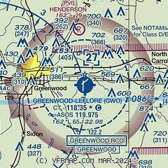
| Sectional chart |
|---|
|
| Airport distance calculator |
|---|
|
|
| Sunrise and sunset |
|---|
|
Times for 02-Jun-2026
| | Local
(UTC-5) | | Zulu
(UTC) |
|---|
| Morning civil twilight | | 05:24 | | 10:24 |
| Sunrise | | 05:52 | | 10:52 |
| Sunset | | 20:05 | | 01:05 |
| Evening civil twilight | | 20:33 | | 01:33 |
|
| Current date and time |
|---|
| Zulu (UTC) | 02-Jun-2026 07:15:15 |
|---|
| Local (UTC-5) | 02-Jun-2026 02:15:15 |
|---|
|
| METAR |
|---|
| KGWO | 011453Z AUTO VRB03KT 10SM CLR 31/25 A3000 RMK AO2 SLP154 T03060250 51004
|
K5A6
18nm E | 020655Z AUTO 12003KT 10SM CLR 21/19 A2997 RMK AO2 LTG DSNT W AND NW T02100191
|
|
| TAF |
|---|
| KGWO | 020520Z 0206/0306 19003KT P6SM SCT100 BKN250 FM021100 10003KT P6SM VCSH BKN100 FM021300 04004KT P6SM BKN015 FM021700 03010KT P6SM BKN050 AMD NOT SKED
|
|
| NOTAMs |
|---|
NOTAMs are issued by the DoD/FAA and will open in a separate window not controlled by AirNav.
|
|


