FAA INFORMATION EFFECTIVE 27 NOVEMBER 2025
Location
| FAA Identifier: | HDN |
| Lat/Long: | 40-28-52.3000N 107-13-03.6000W
40-28.871667N 107-13.060000W
40.4811944,-107.2176667
(estimated) |
| Elevation: | 6606.3 ft. / 2013.6 m (surveyed) |
| Variation: | 10E (2010) |
| From city: | 2 miles SE of HAYDEN, CO |
| Time zone: | UTC -7 (UTC -6 during Daylight Saving Time) |
| Zip code: | 81639 |
Airport Operations
| Airport use: | Open to the public |
| Control tower: | no |
| ARTCC: | DENVER CENTER |
| FSS: | DENVER FLIGHT SERVICE STATION |
| NOTAMs facility: | HDN (NOTAM-D service available) |
| Attendance: | 0600-2100 |
| Wind indicator: | lighted |
| Segmented circle: | yes |
| Lights: | ACTVT MALSF RWY 10; REIL RWY 28; PAPI RWY 10; HIRL RWY 10/28 - CTAF. |
| Beacon: | white-green (lighted land airport)
Operates sunset to sunrise. |
| Landing fee: | yes, LANDING FEE FOR ACFT 12,500 LBS & OVER. |
| Fire and rescue: | ARFF index C |
| Airline operations: | CLSD TO UNSKED ACR OPNS WITH MORE THAN 30 PSGR SEATS EXCP PPR; CALL UNICOM 970-819-1333. |
Airport Communications
| CTAF/UNICOM: | 123.0 |
| WX AWOS-3PT: | 119.275 (970-276-3690) |
| WX ASOS at CAG (14 nm W): | 135.425 (970-824-2373) |
| WX AWOS-3 at SBS (16 nm E): | 118.325 (970-879-7794) |
- BTN 0600 - 2000 CTC UNICOM PRIOR TO ALL TKFS AND LNDGS FOR PAEW ADVISORIES.
- APCH/DEP CTL SVC PRVDD BY DENVER ARTCC (ZDV) ON FREQS 120.475/235.975 (HAYDEN RCAG).
- COMMUNICATIONS PRVDD BY DENVER RADIO ON FREQ 122.3 (HAYDEN RCO).
Nearby radio navigation aids
| VOR radial/distance | | VOR name | | Freq | | Var |
|---|
| CHEr106/4.6 | | HAYDEN VOR/DME | | 115.60 | | 14E |
| BQZr261/15.8 | | ROBERT VOR/DME | | 112.20 | | 13E |
Airport Services
| Fuel available: | 100LL JET-A |
| Parking: | hangars and tiedowns |
| Airframe service: | NONE |
| Powerplant service: | NONE |
| Bottled oxygen: | HIGH/LOW |
Runway Information
Runway 10/28
| Dimensions: | 10000 x 150 ft. / 3048 x 46 m |
| Surface: | asphalt/grooved, in good condition |
| Weight bearing capacity: | | Single wheel: | 75.0 | | Double wheel: | 170.0 | | Double tandem: | 260.0 |
|
| Runway edge lights: | high intensity |
| RUNWAY 10 | | RUNWAY 28 |
| Latitude: | 40-29.202095N | | 40-28.539568N |
| Longitude: | 107-14.046920W | | 107-12.073045W |
| Elevation: | 6580.4 ft. | | 6606.2 ft. |
| Traffic pattern: | right | | left |
| Runway heading: | 104 magnetic, 114 true | | 284 magnetic, 294 true |
| Displaced threshold: | 510 ft. | | no |
| Declared distances: | TORA:10000 TODA:10000 ASDA:10000 LDA:9490 | | TORA:10000 TODA:10000 ASDA:10000 LDA:10000 |
| Markings: | precision, in good condition | | precision, in good condition |
| Visual slope indicator: | 4-light PAPI on left (3.00 degrees glide path) | | 4-light PAPI on left (3.50 degrees glide path) |
| Approach lights: | MALSF: 1,400 foot medium intensity approach lighting system with sequenced flashers | | |
| Runway end identifier lights: | | | yes |
| Touchdown point: | yes, no lights | | yes, no lights |
| Instrument approach: | ILS/DME | | |
| Obstructions: | none
OBSTRUCTION CLNC SLOPE 50:1 TO DSPLCD THLD. | | 110 ft. pline, marked, 3850 ft. from runway, 34:1 slope to clear |
Airport Ownership and Management from official FAA records
| Ownership: | Publicly-owned |
| Owner: | ROUTT COUNTY
PO BOX 773598
STEAMBOAT SPRNGS 80477
Phone 970-879-0108 |
| Manager: | TINNEAL GERBER
11005 RCR 51A, PO BOX 1060
HAYDEN, CO 81639
Phone 970-276-5021 |
Additional Remarks
| A39-10/28 | PCR VALUE: 600/F/D/X/T |
| - | REQ ALL ACFT DEPG RWY 28 MAKE RGT OR LEFT TURNOUT AS SOON AS SAFETY PERMITS AFTER TAKEOFF TO AVOID TOWN OF HAYDEN & COMPLY WITH NOISE ABATEMENT PROCS. |
| - | NO ARFF INDEX 2100-0600 UNLESS EXTN APVD BY ARPT NLT 2300. |
| - | ARFF INDEX B APR 16-DEC 14 0600-2100. ARFF INDEX C DEC 15-APR 15 0600-2100. |
| - | LARGE FLOCKS OF SANDHILL CRANES AROUND ARPT IN SPRING AND FALL. |
| - | ALL ACFT REPORT 10 MINUTES PRIOR TO TKOF/LNDG ON 123.0 - MONITOR FREQ 24 HRS, PAEW ON RWY. |
| - | POSSIBLE SEVERE WINTER CONDITIONS FROM OCT-APR. CHECK NOTAMS FOR ARPT CONDITIONS. NO ARPT INFORMATION NOR SNOW REMOVAL GUARANTEED DURING HOURS OF NONATTENDANCE. |
| - | RWY 28 PAPI DOES NOT PROVIDE OBST CLEARANCE BEYOND 4.0 NM FROM THRESHOLD. |
Instrument Procedures
NOTE: All procedures below are presented as PDF files. If you need a reader for these files, you should download the free Adobe Reader.NOT FOR NAVIGATION. Please procure official charts for flight.
FAA instrument procedures published for use from 27 November 2025 at 0901Z to 25 December 2025 at 0900Z.
STARs - Standard Terminal Arrivals |
|---|
| AAVON ONE (RNAV) | |
download (239KB) |
IAPs - Instrument Approach Procedures |
|---|
| ILS OR LOC RWY 10 | |
download (276KB) |
| RNAV (RNP) Z RWY 10 | |
download (264KB) |
| RNAV (GPS) RWY 28 | |
download (365KB) |
| RNAV (GPS) Y RWY 10 | |
download (257KB) |
| VOR-B | |
download (285KB) |
| NOTE: Special Alternate Minimums apply | |
download (146KB) |
| NOTE: Special Take-Off Minimums/Departure Procedures apply | |
download (105KB) |
Other nearby airports with instrument procedures:
KCAG - Craig-Moffat Airport (14 nm W)
KSBS - Steamboat Springs Airport/Bob Adams Field (16 nm E)
KDWX - Dixon Airport (36 nm N)
KEEO - Meeker Coulter Field Airport (40 nm SW)
33V - Walden-Jackson County Airport (46 nm E)
|
|

Road maps at:
MapQuest
Bing
Google
| Aerial photo |
|---|
WARNING: Photo may not be current or correct
 Photo taken 25-Sep-2006
Do you have a better or more recent aerial photo of Yampa Valley Airport that you would like to share? If so, please send us your photo.
|
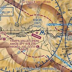
| Sectional chart |
|---|
|
| Airport distance calculator |
|---|
|
|
| Sunrise and sunset |
|---|
|
Times for 27-Nov-2025
| | Local
(UTC-7) | | Zulu
(UTC) |
|---|
| Morning civil twilight | | 06:40 | | 13:40 |
| Sunrise | | 07:10 | | 14:10 |
| Sunset | | 16:43 | | 23:43 |
| Evening civil twilight | | 17:13 | | 00:13 |
|
| Current date and time |
|---|
| Zulu (UTC) | 27-Nov-2025 15:00:20 |
|---|
| Local (UTC-7) | 27-Nov-2025 08:00:20 |
|---|
|
| METAR |
|---|
| KHDN | 271356Z AUTO 07005KT 10SM OVC049 M01/M06 A3040 RMK AO2 SLP311 T10061056 FZRANO $
|
KCAG
14nm W | 271453Z AUTO 00000KT 10SM OVC045 M01/M04 A3040 RMK AO2 SLP324 T10061044 55001
|
KSBS
16nm E | 271435Z AUTO 00000KT 10SM OVC046 M01/M05 A3038 RMK AO1 T10111054
|
|
| TAF |
|---|
| KHDN | 271123Z 2712/2812 10006KT P6SM BKN100 FM272000 27006KT P6SM SCT120 BKN200 FM280200 11005KT P6SM OVC200
|
|
| NOTAMs |
|---|
NOTAMs are issued by the DoD/FAA and will open in a separate window not controlled by AirNav.
|
|


