FAA INFORMATION EFFECTIVE 16 APRIL 2026
Location
| FAA Identifier: | 33V |
| Lat/Long: | 40-45-01.4000N 106-16-17.5000W
40-45.023333N 106-16.291667W
40.7503889,-106.2715278
(estimated) |
| Elevation: | 8153.8 ft. / 2485.3 m (surveyed) |
| Variation: | 10E (2010) |
| From city: | 1 mile NE of WALDEN, CO |
| Time zone: | UTC -6 (UTC -7 during Standard Time) |
| Zip code: | 80480 |
Airport Operations
| Airport use: | Open to the public |
| Activation date: | 04/1940 |
| Control tower: | no |
| ARTCC: | DENVER CENTER |
| FSS: | DENVER FLIGHT SERVICE STATION |
| NOTAMs facility: | DEN (NOTAM-D service available) |
| Attendance: | ON CALL
AMGR OR 970-723-4481 OR 970-846-6971. |
| Wind indicator: | lighted |
| Segmented circle: | yes
MKD WITH YELLOW & BLACK TIRES. |
| Lights: | ACTVT PAPI RWY 04 & 22; MIRL RWY 04/22 - CTAF. |
| Beacon: | white-green (lighted land airport)
Operates sunset to sunrise. |
Airport Communications
| CTAF: | 122.9 |
| WX AWOS-3: | 118.625 (970-723-4513) |
- APCH/DEP SVC PRVDD BY DENVER ARTCC (ZDV) ON FREQS 126.5/371.85 (WALTON PEAK RCAG).
Nearby radio navigation aids
| VOR radial/distance | | VOR name | | Freq | | Var |
|---|
| BQZr045/32.3 | | ROBERT VOR/DME | | 112.20 | | 13E |
Airport Services
Runway Information
Runway 4/22
| Dimensions: | 5900 x 75 ft. / 1798 x 23 m |
| Surface: | asphalt, in excellent condition
RWY 4-22 ASPH PVMT USBL BUT CRACKED THRUT AND DELAMINATING AT APCH ENDS. |
| Weight bearing capacity: | |
| Runway edge lights: | medium intensity |
| RUNWAY 4 | | RUNWAY 22 |
| Latitude: | 40-44.668628N | | 40-45.345558N |
| Longitude: | 106-16.755848W | | 106-15.839863W |
| Elevation: | 8153.1 ft. | | 8150.0 ft. |
| Traffic pattern: | left | | left |
| Runway heading: | 035 magnetic, 045 true | | 215 magnetic, 225 true |
| Markings: | nonprecision, in good condition | | nonprecision, in good condition |
| Visual slope indicator: | 4-light PAPI on left (3.00 degrees glide path) | | 4-light PAPI on left (3.00 degrees glide path) |
| Touchdown point: | yes, no lights | | yes, no lights |
Runway 17/35
| Dimensions: | 4020 x 100 ft. / 1225 x 30 m |
| Surface: | turf, in poor condition
RY 17-35 SFC VERY COURSE WITH ANIMAL BURROWS AND VEGITATION THROUGHOUT. |
| Runway edge markings: | ORANGE CONES. |
| RUNWAY 17 | | RUNWAY 35 |
| Latitude: | 40-45.376310N | | 40-44.714700N |
| Longitude: | 106-16.271647W | | 106-16.290760W |
| Elevation: | 8138.6 ft. | | 8153.6 ft. |
| Traffic pattern: | left | | left |
| Runway heading: | 171 magnetic, 181 true | | 351 magnetic, 001 true |
| Touchdown point: | yes, no lights | | yes, no lights |
| Obstructions: | 4 ft. fence, marked
FENCE POSTS MKD WITH YELLOW PAINT; WORN & FADED. | | 10 ft. road |
Airport Ownership and Management from official FAA records
| Ownership: | Publicly-owned |
| Owner: | JACKSON COUNTY
CO COURTHOUSE PO BOX 1019
WALDEN, CO 80480
Phone 970-723-4660 |
| Manager: | SAMANTHA MARTIN
P. O. BOX 1019
WALDEN, CO 80480
Phone 970-723-4660 |
Additional Remarks
| A30A-35 | +38 FT TREES 300 FT FM THR 154 FT R OF APCH END; +4 FT FENCE AT THR L & R; FENCE POSTS MKD WITH WORN & FADED YELLOW PAINT; ROAD 24 FT FM THR. |
| A30A-17 | 6 FT POLE 100 FT FM THR 10 FT L OF RWY EDGE. |
| A30A-04 | +20 FT PLINE 660 FT FM RWY END 750 FT L OF CNTRLN; 50 FT DROPOFF 450 FT FM THR. |
| - | RDO CTL MODEL ACFT OPS SE CORNER OF ARPT; DEER & ANTELOPE ON RWYS. |
| - | FOR CD CTC DENVER ARTCC AT 303-651-4257. |
| A58-22 | +4 FT BRUSH 10 FT FM THR. |
Instrument Procedures
NOTE: All procedures below are presented as PDF files. If you need a reader for these files, you should download the free Adobe Reader.NOT FOR NAVIGATION. Please procure official charts for flight.
FAA instrument procedures published for use from 16 April 2026 at 0901Z to 14 May 2026 at 0900Z.
IAPs - Instrument Approach Procedures |
|---|
| RNAV (GPS) RWY 04 **CHANGED** | |
download (317KB) |
| RNAV (GPS)-A **CHANGED** | |
download (248KB) |
|
|---|
| WALRU ONE (OBSTACLE) (RNAV) | |
download (145KB) |
| NOTE: Special Take-Off Minimums/Departure Procedures apply | |
download (105KB) |
Other nearby airports with instrument procedures:
KSBS - Steamboat Springs Airport/Bob Adams Field (31 nm SW)
20V - Mc Elroy Airfield (42 nm S)
KGNB - Granby-Grand County Airport (43 nm S)
KLAR - Laramie Regional Airport (43 nm NE)
KHDN - Yampa Valley Airport (46 nm W)
|
|

Road maps at:
MapQuest
Bing
Google
| Aerial photo |
|---|
WARNING: Photo may not be current or correct
 Photo by Todd Suko
Photo taken 19-Aug-2007
Photo by Todd Suko
Photo taken 19-Aug-2007
Do you have a better or more recent aerial photo of Walden-Jackson County Airport that you would like to share? If so, please send us your photo.
|
| Sectional chart |
|---|
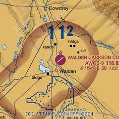
|
| Airport distance calculator |
|---|
|
|
| Sunrise and sunset |
|---|
|
Times for 08-May-2026
| | Local
(UTC-6) | | Zulu
(UTC) |
|---|
| Morning civil twilight | | 05:26 | | 11:26 |
| Sunrise | | 05:56 | | 11:56 |
| Sunset | | 20:07 | | 02:07 |
| Evening civil twilight | | 20:38 | | 02:38 |
|
| Current date and time |
|---|
| Zulu (UTC) | 08-May-2026 18:30:01 |
|---|
| Local (UTC-6) | 08-May-2026 12:30:01 |
|---|
|
| METAR |
|---|
| K33V | 081815Z AUTO 26005KT 10SM SCT090 12/00 A3013 RMK AO1
|
|
| TAF |
|---|
KLAR
44nm NE | 081720Z 0818/0918 33014G25KT P6SM SCT060 BKN120 FM090200 24010KT P6SM SCT120 FM090600 24010KT P6SM BKN080 FM091500 30012G24KT P6SM SCT080
|
KHDN
46nm W | 081807Z 0818/0918 27012G16KT P6SM SKC FM081900 28010G18KT P6SM FEW050 SCT250 FM090000 27006KT P6SM FEW250
|
|
| NOTAMs |
|---|
NOTAMs are issued by the DoD/FAA and will open in a separate window not controlled by AirNav.
|
|


