FAA INFORMATION EFFECTIVE 14 MAY 2026
Location
| FAA Identifier: | GNB |
| Lat/Long: | 40-05-24.2000N 105-54-59.9000W
40-05.403333N 105-54.998333W
40.0900556,-105.9166389
(estimated) |
| Elevation: | 8207.1 ft. / 2501.5 m (surveyed) |
| Variation: | 08E (2025) |
| From city: | 1 mile NE of GRANBY, CO |
| Time zone: | UTC -6 (UTC -7 during Standard Time) |
| Zip code: | 80446 |
Airport Operations
| Airport use: | Open to the public |
| Activation date: | 12/1945 |
| Control tower: | no |
| ARTCC: | DENVER CENTER |
| FSS: | DENVER FLIGHT SERVICE STATION |
| NOTAMs facility: | DEN (NOTAM-D service available) |
| Attendance: | UNATNDD |
| Wind indicator: | lighted |
| Segmented circle: | yes |
| Lights: | ACTVT REIL RWY 09 & 27; LIRL RWY 09/27 - CTAF. |
| Beacon: | white-green (lighted land airport)
Operates sunset to sunrise. |
Airport Communications
| CTAF/UNICOM: | 123.0 |
| WX AWOS-3PT: | 119.925 (970-887-1803) |
- APCH/DEP CTL SVC PRVDD BY DENVER ARTCC (ZDV) ON FREQS 128.65/282.2 (KREMMLING RCAG).
Nearby radio navigation aids
| VOR radial/distance | | VOR name | | Freq | | Var |
|---|
| RLGr064/24.7 | | KREMMLING VOR/DME | | 113.80 | | 14E |
| BJCr276/37.3 | | JEFFCO VOR/DME | | 115.40 | | 11E |
Airport Services
| Fuel available: | 100LL JET-A
100LL:FUEL AVBL 24 HR SELF SVC. |
| Parking: | tiedowns |
| Airframe service: | NONE |
| Powerplant service: | NONE |
| Bottled oxygen: | NONE |
| Bulk oxygen: | NONE |
Runway Information
Runway 9/27
| Dimensions: | 5001 x 75 ft. / 1524 x 23 m |
| Surface: | asphalt, in fair condition |
| Weight bearing capacity: | | Single wheel: | 15.0 | | Double wheel: | 15.0 |
|
| Runway edge lights: | low intensity |
| RUNWAY 9 | | RUNWAY 27 |
| Latitude: | 40-05.489635N | | 40-05.316728N |
| Longitude: | 105-55.523063W | | 105-54.475103W |
| Elevation: | 8160.1 ft. | | 8207.1 ft. |
| Traffic pattern: | left | | right |
| Runway heading: | 094 magnetic, 102 true | | 274 magnetic, 282 true |
| Markings: | nonprecision, in fair condition | | nonprecision, in fair condition |
| Visual slope indicator: | 2-light PAPI on left (3.00 degrees glide path) | | |
| Runway end identifier lights: | yes | | yes |
| Touchdown point: | yes, no lights | | yes, no lights |
| Obstructions: | none | | 16 ft. fence, 325 ft. from runway, 128 ft. right of centerline, 7:1 slope to clear |
Airport Ownership and Management from official FAA records
| Ownership: | Publicly-owned |
| Owner: | GRAND COUNTY
P.O. BOX 264, P.O. BOX 264
HOT SULPHUR SPRINGS, CO 80451
Phone 970-725-3347 |
| Manager: | SHAWN MAHORNEY
P O BOX 264
HOT SULPHUR SPRINGS, CO 80451
Phone 970-887-2123
ARPT CONTACT; JOSHUA SCHROEDER - JSCHROEDER@CO.GRAND.CO.US, 970-887-2123. |
Additional Remarks
| - | RCMD TKOF TO EAST ONLY BY EXPERIENCED PILOTS; HIGH GROUND RISES QUICKLY TO THE EAST. |
| - | RWY 27 HAS +525 FT TERRAIN 6000 FT FM THLD 1400 LEFT OF CNTRLN, +52 FT TERRAIN 1200 FT FM THLD ON EXTNDD CNTRLN, +40 FT POWERLINE 965 FT FM THLD 260 LEFT OF CNTRLN. |
| - | FOR CD CTC DENVER ARTCC AT 303-651-4257. |
| - | RWY 09 HAS +563 FT TERRAIN 21277 FT FM THLD 371 FT LEFT OF CNTRLN. |
| - | COLD TEMPERATURE AIRPORT. ALTITUDE CORRECTION REQUIRED AT OR BELOW -24C. |
Instrument Procedures
NOTE: All procedures below are presented as PDF files. If you need a reader for these files, you should download the free Adobe Reader.NOT FOR NAVIGATION. Please procure official charts for flight.
FAA instrument procedures published for use from 14 May 2026 at 0901Z to 11 June 2026 at 0900Z.
IAPs - Instrument Approach Procedures |
|---|
| RNAV (GPS)-C | |
download (344KB) |
| NOTE: Special Alternate Minimums apply | |
download (141KB) |
|
|---|
| JANKE ONE (OBSTACLE) (RNAV) | |
download (130KB) |
| NOTE: Special Take-Off Minimums/Departure Procedures apply | |
download (292KB) |
Other nearby airports with instrument procedures:
20V - Mc Elroy Airfield (21 nm W)
KLMO - Vance Brand Airport (35 nm E)
KBJC - Rocky Mountain Metro Airport (38 nm E)
KEIK - Erie Municipal Airport (40 nm E)
33V - Walden-Jackson County Airport (43 nm N)
|
|

Road maps at:
MapQuest
Bing
Google
| Aerial photo |
|---|
WARNING: Photo may not be current or correct
 Photo by Melissa Sircar
Photo taken 02-Jul-2011
looking east.
Photo by Melissa Sircar
Photo taken 02-Jul-2011
looking east.
Do you have a better or more recent aerial photo of Granby-Grand County Airport that you would like to share? If so, please send us your photo.
|
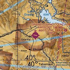
| Sectional chart |
|---|
|
| Airport distance calculator |
|---|
|
|
| Sunrise and sunset |
|---|
|
Times for 02-Jun-2026
| | Local
(UTC-6) | | Zulu
(UTC) |
|---|
| Morning civil twilight | | 05:05 | | 11:05 |
| Sunrise | | 05:37 | | 11:37 |
| Sunset | | 20:26 | | 02:26 |
| Evening civil twilight | | 20:58 | | 02:58 |
|
| Current date and time |
|---|
| Zulu (UTC) | 02-Jun-2026 15:31:58 |
|---|
| Local (UTC-6) | 02-Jun-2026 09:31:58 |
|---|
|
| METAR |
|---|
| KGNB | 021515Z AUTO 00000KT 10SM CLR 14/03 A3039 RMK AO2 T01440030
|
K0CO
19nm S | 021455Z AUTO 13009G15KT 10SM BKN095 05/00 A3063 RMK AO2
|
|
| NOTAMs |
|---|
NOTAMs are issued by the DoD/FAA and will open in a separate window not controlled by AirNav.
|
|

