FAA INFORMATION EFFECTIVE 19 MARCH 2026
Location
| FAA Identifier: | HOT |
| Lat/Long: | 34-28-40.9000N 093-05-46.4000W
34-28.681667N 093-05.773333W
34.4780278,-93.0962222
(estimated) |
| Elevation: | 540.3 ft. / 164.7 m (surveyed) |
| Variation: | 01E (2020) |
| From city: | 3 miles SW of HOT SPRINGS, AR |
| Time zone: | UTC -5 (UTC -6 during Standard Time) |
| Zip code: | 71913 |
Airport Operations
| Airport use: | Open to the public |
| Activation date: | 04/1940 |
| Control tower: | no |
| ARTCC: | MEMPHIS CENTER |
| FSS: | JONESBORO FLIGHT SERVICE STATION |
| NOTAMs facility: | HOT (NOTAM-D service available) |
| Attendance: | 0500-2200 |
| Wind indicator: | lighted |
| Segmented circle: | yes |
| Lights: | ACTVT HIRL RY 05/23; MIRL RY 13/31; MALSR RY 05; PAPI RY 23 & REIL RY 13 - CTAF. |
| Beacon: | white-green (lighted land airport)
Operates sunset to sunrise. |
| Fire and rescue: | ARFF index A |
Airport Communications
| CTAF/UNICOM: | 123.0 |
| WX ASOS: | 119.925 (501-624-7633) |
- APCH/DEP SVC PRVDD BY MEMPHIS ARTCC ON FREQS 128.475/377.15 (HOT SPRINGS RCAG).
Nearby radio navigation aids
| VOR radial/distance | | VOR name | | Freq | | Var |
|---|
| HOT at field | | HOT SPRINGS VOR/DME | | 110.00 | | 04E |
| NDB name | | Hdg/Dist | | Freq | | Var | | ID |
|---|
| HOSSY | | 053/5.7 | | 385 | | 01E | | HO | .... --- |
Airport Services
| Fuel available: | 100LL JET-A
100LL:FOR FUEL AFT HRS CALL 501-617-0324. |
| Parking: | hangars and tiedowns |
| Airframe service: | MAJOR |
| Powerplant service: | MAJOR |
| Bottled oxygen: | NONE |
| Bulk oxygen: | NONE |
Runway Information
Runway 5/23
| Dimensions: | 6595 x 150 ft. / 2010 x 46 m |
| Surface: | asphalt/grooved, in good condition |
| Weight bearing capacity: | | Single wheel: | 75.0 | | Double wheel: | 125.0 | | Double tandem: | 210.0 | | Dual double tandem: | 400.0 |
|
| Runway edge lights: | high intensity |
| RUNWAY 5 | | RUNWAY 23 |
| Latitude: | 34-28.381252N | | 34-29.016142N |
| Longitude: | 093-06.375818W | | 093-05.310055W |
| Elevation: | 501.6 ft. | | 540.3 ft. |
| Traffic pattern: | right | | left |
| Runway heading: | 053 magnetic, 054 true | | 233 magnetic, 234 true |
| Declared distances: | TORA:6595 TODA:6595 ASDA:6595 LDA:6595 | | TORA:6595 TODA:6595 ASDA:6235 LDA:6235 |
| Markings: | precision, in good condition | | nonprecision, in good condition |
| Visual slope indicator: | | | 4-light PAPI on left (3.00 degrees glide path)
RWY 23 PAPI UNUSBL BYD 6 DEGS RIGHT OF CNTRLN. |
| Approach lights: | MALSR: 1,400 foot medium intensity approach lighting system with runway alignment indicator lights | | |
| Touchdown point: | yes, no lights | | yes, no lights |
| Instrument approach: | ILS/DME | | |
| Obstructions: | none | | 78 ft. pole, lighted, 1800 ft. from runway, 650 ft. right of centerline, 20:1 slope to clear |
Runway 13/31
| Dimensions: | 4098 x 100 ft. / 1249 x 30 m |
| Surface: | asphalt, in good condition |
| Weight bearing capacity: | | Single wheel: | 28.0 | | Double wheel: | 36.0 | | Double tandem: | 63.0 |
|
| Runway edge lights: | medium intensity |
| RUNWAY 13 | | RUNWAY 31 |
| Latitude: | 34-28.888825N | | 34-28.417367N |
| Longitude: | 093-05.955317W | | 093-05.371108W |
| Elevation: | 519.8 ft. | | 505.3 ft. |
| Traffic pattern: | right | | left |
| Runway heading: | 133 magnetic, 134 true | | 313 magnetic, 314 true |
| Declared distances: | TORA:3210 TODA:4098 ASDA:4098 LDA:4098 | | TORA:4098 TODA:4098 ASDA:4098 LDA:3210 |
| Markings: | basic, in good condition | | basic, in good condition |
| Runway end identifier lights: | yes | | |
| Touchdown point: | yes, no lights | | yes, no lights |
| Obstructions: | 40 ft. trees, 600 ft. from runway, 150 ft. left of centerline, 10:1 slope to clear | | 121 ft. pole, lighted, 3200 ft. from runway, 300 ft. right of centerline, 24:1 slope to clear |
Airport Ownership and Management from official FAA records
| Ownership: | Publicly-owned |
| Owner: | CITY OF HOT SPRINGS
PO BOX 700
HOT SPRINGS, AR 71902
Phone 501-321-6810 |
| Manager: | DON ROWLETT
525 AIRPORT ROAD
HOT SPRINGS, AR 71913
Phone 501-321-6750 |
Additional Remarks
| A39-05/23 | PCR VALUE: 370/F/B/X/U |
| A39-13/31 | PCR VALUE: 28/F/B/Y/U |
| - | FOR CD CTC MEMPHIS ARTCC AT 901-368-8453. |
Instrument Procedures
NOTE: All procedures below are presented as PDF files. If you need a reader for these files, you should download the free Adobe Reader.NOT FOR NAVIGATION. Please procure official charts for flight.
FAA instrument procedures published for use from 19 March 2026 at 0901Z to 16 April 2026 at 0900Z.
IAPs - Instrument Approach Procedures |
|---|
| ILS OR LOC RWY 05 | |
download (282KB) |
| RNAV (GPS) RWY 05 | |
download (233KB) |
| VOR RWY 05 | |
download (302KB) |
| NOTE: Special Alternate Minimums apply | |
download (123KB) |
| NOTE: Special Take-Off Minimums/Departure Procedures apply | |
download (391KB) |
Other nearby airports with instrument procedures:
M78 - Malvern Municipal Airport (19 nm SE)
KADF - Dexter B Florence Memorial Field Airport (23 nm S)
KSUZ - Saline County Regional Airport (31 nm E)
9M8 - Sheridan-Grant County Regional Airport (38 nm E)
32A - Danville Municipal Airport (40 nm NW)
|
|

Road maps at:
MapQuest
Bing
Google
| Aerial photo |
|---|
WARNING: Photo may not be current or correct
 Photo courtesy of the Arkansas Department of Aeronautics
Taken in the Spring of 2007
Photo courtesy of the Arkansas Department of Aeronautics
Taken in the Spring of 2007
Do you have a better or more recent aerial photo of Memorial Field Airport that you would like to share? If so, please send us your photo.
|
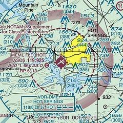
| Sectional chart |
|---|
|
| Airport distance calculator |
|---|
|
|
| Sunrise and sunset |
|---|
|
Times for 01-Apr-2026
| | Local
(UTC-5) | | Zulu
(UTC) |
|---|
| Morning civil twilight | | 06:35 | | 11:35 |
| Sunrise | | 07:01 | | 12:01 |
| Sunset | | 19:32 | | 00:32 |
| Evening civil twilight | | 19:57 | | 00:57 |
|
| Current date and time |
|---|
| Zulu (UTC) | 01-Apr-2026 07:22:08 |
|---|
| Local (UTC-5) | 01-Apr-2026 02:22:08 |
|---|
|
| METAR |
|---|
| KHOT | 010653Z AUTO 23007KT 10SM CLR 22/15 A3000 RMK AO2 SLP153 T02220150
|
|
| TAF |
|---|
| KHOT | 010520Z 0106/0206 VRB05KT P6SM BKN250 FM011400 20007KT P6SM SCT015 BKN050 TEMPO 0114/0117 6SM BR OVC015 FM011800 20012G20KT P6SM BKN050 FM020000 16008KT P6SM OVC250
|
|
| NOTAMs |
|---|
NOTAMs are issued by the DoD/FAA and will open in a separate window not controlled by AirNav.
|
|

