FAA INFORMATION EFFECTIVE 09 JULY 2026
Location
| FAA Identifier: | SUZ |
| Lat/Long: | 34-35-25.4000N 092-28-46.0000W
34-35.423333N 092-28.766667W
34.5903889,-92.4794444
(estimated) |
| Elevation: | 389.4 ft. / 119 m (estimated) |
| Variation: | 01E (2010) |
| From city: | 5 miles E of BENTON, AR |
| Time zone: | UTC -5 (UTC -6 during Standard Time) |
| Zip code: | 72022 |
Airport Operations
| Airport use: | Open to the public |
| Activation date: | 12/2006 |
| Control tower: | no |
| ARTCC: | MEMPHIS CENTER |
| FSS: | JONESBORO FLIGHT SERVICE STATION |
| NOTAMs facility: | JBR (NOTAM-D service available) |
| Attendance: | MON-FRI 0800-1630
SELF SERVE 100LL & JET A AVBL 24/7, FOR SVC AFTER HOURS CALL 501-672-9809 CALL OUT FEE |
| Wind indicator: | lighted |
| Segmented circle: | yes |
| Lights: | ACTVT REIL RWYS 02 & 20; MIRL RWY 02/20 - CTAF. |
| Beacon: | white-green (lighted land airport)
Operates sunset to sunrise. |
Airport Communications
| CTAF/UNICOM: | 122.8 |
| WX AWOS-3: | 132.125 (501-847-3883) |
| LITTLE ROCK APPROACH: | 119.5 |
| LITTLE ROCK DEPARTURE: | 119.5 |
| WX ASOS at LIT (15 nm NE): | PHONE 501-376-0247 |
| WX AWOS-3PT at ORK (18 nm NE): | 123.775 (501-906-6529) |
Nearby radio navigation aids
| VOR radial/distance | | VOR name | | Freq | | Var |
|---|
| LITr231/20.8 | | LITTLE ROCK VORTAC | | 115.10 | | 00W |
| HOTr073/30.9 | | HOT SPRINGS VOR/DME | | 110.00 | | 04E |
| PBFr303/34.3 | | PINE BLUFF VOR/DME | | 116.00 | | 04E |
Airport Services
| Fuel available: | 100LL JET-A+
100LL:SELF SVC FUEL AVBL 24 HRS WITH CREDIT CARD. |
| Parking: | tiedowns |
| Airframe service: | MINOR |
| Powerplant service: | MAJOR |
Runway Information
Runway 2/20
| Dimensions: | 5002 x 100 ft. / 1525 x 30 m |
| Surface: | asphalt, in excellent condition |
| Weight bearing capacity: | | Single wheel: | 54.0 | | Double wheel: | 65.0 | | Double tandem: | 111.0 |
|
| Runway edge lights: | medium intensity |
| RUNWAY 2 | | RUNWAY 20 |
| Latitude: | 34-35.036550N | | 34-35.811415N |
| Longitude: | 092-28.936597W | | 092-28.595762W |
| Elevation: | 389.4 ft. | | 387.5 ft. |
| Traffic pattern: | right | | left |
| Runway heading: | 019 magnetic, 020 true | | 199 magnetic, 200 true |
| Markings: | nonprecision, in good condition | | nonprecision, in good condition |
| Visual slope indicator: | 4-light PAPI on left (3.00 degrees glide path) | | 4-light PAPI on left (3.00 degrees glide path) |
| Runway end identifier lights: | yes | | yes |
| Touchdown point: | yes, no lights | | yes, no lights |
| Instrument approach: | ILS/DME | | |
| Obstructions: | 38 ft. trees, 1650 ft. from runway, 38:1 slope to clear | | 30 ft. tree, 980 ft. from runway, 575 ft. right of centerline, 26:1 slope to clear |
Airport Ownership and Management from official FAA records
| Ownership: | Publicly-owned |
| Owner: | SALINE COUNTY
200 N MAIN ST
BENTON, AR 72015
Phone 501-303-5690 |
| Manager: | AJ AMBORT
1100 HILL FARM ROAD
BRYANT, AR 72022
Phone (501) 672-9809 |
Additional Remarks
| - | COURTESY CAR AVBL. AFT HRS, CTC AMGR FOR TRML BLDG ENTRY CODE. |
| - | FOR CD CTC LITTLE ROCK APCH 501-379-2908 OR LITTLE ROCK ATCT 501-379-2911. |
Instrument Procedures
NOTE: All procedures below are presented as PDF files. If you need a reader for these files, you should download the free Adobe Reader.NOT FOR NAVIGATION. Please procure official charts for flight.
FAA instrument procedures published for use from 09 July 2026 at 0901Z to 06 August 2026 at 0900Z.
IAPs - Instrument Approach Procedures |
|---|
| ILS OR LOC RWY 02 | |
download (253KB) |
| RNAV (GPS) RWY 02 | |
download (232KB) |
| RNAV (GPS) RWY 20 | |
download (191KB) |
| NOTE: Special Alternate Minimums apply | |
download (144KB) |
| NOTE: Special Take-Off Minimums/Departure Procedures apply | |
download (190KB) |
Other nearby airports with instrument procedures:
KLIT - Bill and Hillary Clinton National Airport/Adams Field (15 nm NE)
9M8 - Sheridan-Grant County Regional Airport (17 nm S)
KORK - North Little Rock Municipal Airport (18 nm NE)
M78 - Malvern Municipal Airport (21 nm SW)
KLRF - Little Rock Air Force Base (26 nm NE)
|
|

Road maps at:
MapQuest
Bing
Google
| Aerial photo |
|---|
WARNING: Photo may not be current or correct
 Photo taken 28-Jan-2019
looking west-northwest.
Photo taken 28-Jan-2019
looking west-northwest.
Do you have a better or more recent aerial photo of Saline County Regional Airport that you would like to share? If so, please send us your photo.
|
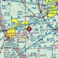
| Sectional chart |
|---|
|
| Airport distance calculator |
|---|
|
|
| Sunrise and sunset |
|---|
|
Times for 26-Jul-2026
| | Local
(UTC-5) | | Zulu
(UTC) |
|---|
| Morning civil twilight | | 05:49 | | 10:49 |
| Sunrise | | 06:17 | | 11:17 |
| Sunset | | 20:16 | | 01:16 |
| Evening civil twilight | | 20:44 | | 01:44 |
|
| Current date and time |
|---|
| Zulu (UTC) | 26-Jul-2026 16:01:18 |
|---|
| Local (UTC-5) | 26-Jul-2026 11:01:18 |
|---|
|
| METAR |
|---|
| KSUZ | 261515Z AUTO VRB05KT 6SM HZ CLR 32/25 A3002 RMK A01
|
KLIT
15nm NE | 261553Z 25008KT 10SM CLR 34/23 A3001 RMK AO2 SLP159 T03440228
|
KORK
18nm NE | 261515Z AUTO 30007KT 10SM CLR 32/22 A3001 RMK AO2
|
|
| TAF |
|---|
KLIT
15nm NE | 261120Z 2612/2712 25006KT P6SM SKC FM261400 27008KT P6SM SCT080 SCT120 FM270000 19005KT P6SM BKN250 FM270600 23004KT P6SM BKN250
|
|
| NOTAMs |
|---|
NOTAMs are issued by the DoD/FAA and will open in a separate window not controlled by AirNav.
|
|

