FAA INFORMATION EFFECTIVE 14 MAY 2026
Location
| FAA Identifier: | HQM |
| Lat/Long: | 46-58-16.3000N 123-56-11.6000W
46-58.271667N 123-56.193333W
46.9711944,-123.9365556
(estimated) |
| Elevation: | 17.8 ft. / 5.4 m (surveyed) |
| Variation: | 19E (1995) |
| From city: | 2 miles W of HOQUIAM, WA |
| Time zone: | UTC -7 (UTC -8 during Standard Time) |
| Zip code: | 98550 |
Airport Operations
| Airport use: | Open to the public |
| Activation date: | 04/1944 |
| Control tower: | no |
| ARTCC: | SEATTLE CENTER |
| FSS: | SEATTLE FLIGHT SERVICE STATION |
| NOTAMs facility: | HQM (NOTAM-D service available) |
| Attendance: | UNATNDD |
| Wind indicator: | lighted |
| Segmented circle: | yes |
| Lights: | ACTVT HIRL RY 06/24, PAPI RWY 06/24, MALSR RY 24 & REIL RY 06 - CTAF. |
| Beacon: | white-green (lighted land airport)
Operates sunset to sunrise. |
| International operations: | customs landing rights airport |
Airport Communications
| CTAF/UNICOM: | 122.7 |
| WX ASOS: | 135.775 (360-538-7021) |
- APCH/DEP CTL SVC PRVDD BY SEATTLE ARTCC (ZSE) ON FREQS 128.3/269.0 (HOQUIAM RCAG).
Nearby radio navigation aids
| VOR radial/distance | | VOR name | | Freq | | Var |
|---|
| HQMr062/8.8 | | HOQUIAM VORTAC | | 117.70 | | 19E |
Airport Services
| Fuel available: | 100LL JET-A
100LL:100LL AND JET A AVBL 24 HRS A DAY WITH MAJOR CREDIT CARD. |
| Parking: | tiedowns |
| Airframe service: | NONE |
| Powerplant service: | NONE |
| Bottled oxygen: | NONE |
| Bulk oxygen: | NONE |
Runway Information
Runway 6/24
| Dimensions: | 5000 x 150 ft. / 1524 x 46 m |
| Surface: | asphalt, in good condition |
| Weight bearing capacity: | | Single wheel: | 30.0 | | Double wheel: | 40.0 | | Double tandem: | 80.0 |
|
| Runway edge lights: | high intensity |
| RUNWAY 6 | | RUNWAY 24 |
| Latitude: | 46-58.199200N | | 46-58.344338N |
| Longitude: | 123-56.785215W | | 123-55.602435W |
| Elevation: | 17.5 ft. | | 15.1 ft. |
| Traffic pattern: | right | | left |
| Runway heading: | 060 magnetic, 079 true | | 240 magnetic, 259 true |
| Markings: | nonprecision, in fair condition | | precision, in fair condition |
| Visual slope indicator: | 4-light PAPI on right (3.00 degrees glide path) | | 4-light PAPI on left (3.50 degrees glide path) |
| Approach lights: | | | MALSR: 1,400 foot medium intensity approach lighting system with runway alignment indicator lights |
| Runway end identifier lights: | yes | | |
| Touchdown point: | yes, no lights | | yes, no lights |
| Instrument approach: | | | ILS/DME |
Airport Ownership and Management from official FAA records
| Ownership: | Publicly-owned |
| Owner: | PORT OF GRAYS HARBOR
BOX 660, 111 S WOODING STREET
ABERDEEN, WA 98520
Phone 360-533-9528 |
| Manager: | SHANNON ANDERSON
BOX 660, 111 S WOODING STREET
ABERDEEN, WA 98520
Phone 360-533-9544
AMGR CELL 360-310-0201. |
Additional Remarks
| - | FLOCKS OF WATERFOWL ON AND IN VCNTY ARPT. CAUTION ADZD. |
| - | SERVICE ROAD SOUTH OF RY IN PRIMARY SURFACE. |
| - | ULTRALIGHTS PROHIBITED WITHOUT WRITTEN PERMISSON FROM ARPT MGR. |
| - | 103 FT CRANE 0.2 NM SW OF AER RY 24. |
| - | FOR CD IF UNA TO CTC ON FSS FREQ, CTC SEATTLE ARTCC AT 253-351-3694. |
Instrument Procedures
NOTE: All procedures below are presented as PDF files. If you need a reader for these files, you should download the free Adobe Reader.NOT FOR NAVIGATION. Please procure official charts for flight.
FAA instrument procedures published for use from 14 May 2026 at 0901Z to 11 June 2026 at 0900Z.
IAPs - Instrument Approach Procedures |
|---|
| ILS OR LOC RWY 24 | |
download (289KB) |
| RNAV (GPS) RWY 06 | |
download (231KB) |
| RNAV (GPS) RWY 24 | |
download (256KB) |
| VOR RWY 06 | |
download (214KB) |
| NOTE: Special Alternate Minimums apply | |
download (212KB) |
| NOTE: Special Take-Off Minimums/Departure Procedures apply | |
download (559KB) |
Other nearby airports with instrument procedures:
KSHN - Sanderson Field Airport (36 nm NE)
KOLM - Olympia Regional Airport (42 nm E)
KCLS - Chehalis-Centralia Airport (43 nm SE)
KAST - Astoria Regional Airport (49 nm S)
KTDO - Ed Carlson Memorial Field/South Lewis County Airport (55 nm SE)
|
|

Road maps at:
MapQuest
Bing
Google
| Aerial photo |
|---|
WARNING: Photo may not be current or correct
 Photo by Greg Novotny
Photo taken 01-Jun-2020
looking southwest.
Photo by Greg Novotny
Photo taken 01-Jun-2020
looking southwest.
Do you have a better or more recent aerial photo of Bowerman Field Airport that you would like to share? If so, please send us your photo.
|
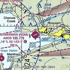
| Sectional chart |
|---|
|
| Airport distance calculator |
|---|
|
|
| Sunrise and sunset |
|---|
|
Times for 02-Jun-2026
| | Local
(UTC-7) | | Zulu
(UTC) |
|---|
| Morning civil twilight | | 04:46 | | 11:46 |
| Sunrise | | 05:25 | | 12:25 |
| Sunset | | 21:02 | | 04:02 |
| Evening civil twilight | | 21:41 | | 04:41 |
|
| Current date and time |
|---|
| Zulu (UTC) | 02-Jun-2026 20:53:04 |
|---|
| Local (UTC-7) | 02-Jun-2026 13:53:04 |
|---|
|
| METAR |
|---|
| KHQM | 021953Z AUTO 11004KT 10SM CLR 27/06 A2999 RMK AO2 SLP157 T02670056
|
|
| TAF |
|---|
| KHQM | 021742Z 0218/0318 11010KT P6SM SKC FM022100 25010KT P6SM SKC FM030300 23008KT P6SM BKN100 FM030600 24011KT P6SM SCT003 OVC007 FM031100 23008KT P6SM -SHRA OVC015 FM031400 20007KT P6SM -SHRA OVC015
|
|
| NOTAMs |
|---|
NOTAMs are issued by the DoD/FAA and will open in a separate window not controlled by AirNav.
|
|

