FAA INFORMATION EFFECTIVE 09 JULY 2026
Location
| FAA Identifier: | IKW |
| Lat/Long: | 43-39-46.5320N 084-15-40.7260W
43-39.775533N 084-15.678767W
43.6629256,-84.2613128
(estimated) |
| Elevation: | 634.7 ft. / 193.5 m (surveyed) |
| Variation: | 06W (2000) |
| From city: | 3 miles NW of MIDLAND, MI |
| Time zone: | UTC -4 (UTC -5 during Standard Time) |
| Zip code: | 48642 |
Airport Operations
| Airport use: | Open to the public |
| Activation date: | 09/1948 |
| Control tower: | no |
| ARTCC: | CLEVELAND CENTER |
| FSS: | LANSING FLIGHT SERVICE STATION |
| NOTAMs facility: | IKW (NOTAM-D service available) |
| Attendance: | MON-FRI 0900-1700, ALL SAT-SUN 0800-1600
UNATNDD MAJOR HOLS. |
| Wind indicator: | lighted |
| Segmented circle: | yes |
| Lights: | ACTVT REIL RWY 06, 24, 18, & 36; PAPI RWY 06 & 24; MIRL RWY 06/24 & 18/36 - CTAF. |
| Beacon: | white-green (lighted land airport)
Operates sunset to sunrise. |
Airport Communications
| CTAF/UNICOM: | 122.8 |
| WX AWOS-3P: | 119.525 (989-835-5841) |
| GREAT LAKES APPROACH: | 126.45 |
| GREAT LAKES DEPARTURE: | 126.45 |
| WX ASOS at MBS (11 nm SE): | PHONE 989-695-2488 |
- APCH/DEP SVC PRVDD BY CLEVELAND ARTCC (ZOB) ON FREQS 127.7/290.425 (FREELAND RCAG) WHEN GREAT LAKES APCH CTL CLSD.
Nearby radio navigation aids
| VOR radial/distance | | VOR name | | Freq | | Var |
|---|
| MBSr318/11.2 | | SAGINAW VOR/DME | | 114.35 | | 03W |
| NDB name | | Hdg/Dist | | Freq | | Var | | ID |
|---|
| OLSTE | | 351/12.6 | | 257 | | 07W | | MB | -- -... |
Airport Services
| Fuel available: | 100LL JET-A+
100LL:100LL & JET A+ AVBL SELF SVC; JET A+ AVBL FULL SVC BY PRIOR ARNGMT. |
| Parking: | hangars and tiedowns |
| Airframe service: | NONE |
| Powerplant service: | NONE |
| Bottled oxygen: | NONE |
| Bulk oxygen: | NONE |
Runway Information
Runway 6/24
| Dimensions: | 3801 x 75 ft. / 1159 x 23 m |
| Surface: | asphalt, in good condition |
| Weight bearing capacity: | |
| Runway edge lights: | medium intensity |
| RUNWAY 6 | | RUNWAY 24 |
| Latitude: | 43-39.612753N | | 43-39.925065N |
| Longitude: | 084-15.920062W | | 084-15.173450W |
| Elevation: | 621.2 ft. | | 634.7 ft. |
| Traffic pattern: | left | | left |
| Runway heading: | 066 magnetic, 060 true | | 246 magnetic, 240 true |
| Markings: | nonprecision, in fair condition | | nonprecision, in fair condition |
| Visual slope indicator: | 2-light PAPI on left (3.00 degrees glide path) | | 2-light PAPI on left (3.00 degrees glide path) |
| Runway end identifier lights: | yes | | yes |
| Touchdown point: | yes, no lights | | yes, no lights |
| Obstructions: | 84 ft. tree, 814 ft. from runway, 370 ft. right of centerline, 7:1 slope to clear | | 76 ft. tree, 1105 ft. from runway, 414 ft. left of centerline, 11:1 slope to clear |
Runway 18/36
| Dimensions: | 3001 x 75 ft. / 915 x 23 m |
| Surface: | asphalt, in good condition |
| Weight bearing capacity: | |
| Runway edge lights: | medium intensity |
| RUNWAY 18 | | RUNWAY 36 |
| Latitude: | 43-40.030873N | | 43-39.536913N |
| Longitude: | 084-15.845512W | | 084-15.846350W |
| Elevation: | 627.8 ft. | | 621.1 ft. |
| Traffic pattern: | left | | left |
| Runway heading: | 186 magnetic, 180 true | | 006 magnetic, 000 true |
| Markings: | nonprecision, in fair condition | | nonprecision, in fair condition |
| Runway end identifier lights: | yes | | yes |
| Touchdown point: | yes, no lights | | yes, no lights |
| Obstructions: | 79 ft. tree, 1305 ft. from runway, 269 ft. left of centerline, 13:1 slope to clear | | 41 ft. tree, 929 ft. from runway, 137 ft. left of centerline, 17:1 slope to clear |
Airport Ownership and Management from official FAA records
| Ownership: | Publicly-owned |
| Owner: | CITY OF MIDLAND
333 W ELLSWORTH ST
MIDLAND, MI 48640-5132
Phone 989-837-3300 |
| Manager: | SARAH PAGANO
6603 BARSTOW DR
MIDLAND, MI 48642-7783
Phone 989-835-3231
CELL 989-492-0252. |
Additional Remarks
| - | DEER & LRG BIRDS ON & INVOF ARPT. |
| - | OCNL ULTRALIGHT ACT. |
| - | NOISE SENSITIVE AREA SOUTH OF ARPT, USE PREFERRED RWY 06/24. |
| - | FOR CD CTC GREAT LAKES APCH AT 269-459-3345, WHEN APCH CLSD CTC CLEVELAND ARTCC AT 440-774-0224/0490. |
| - | FLD CONDS UNMON WKDAYS 1800-0800 & WKENDS 1600-0800. |
| - | DOOR CODE: 5-3-2-1. |
Instrument Procedures
NOTE: All procedures below are presented as PDF files. If you need a reader for these files, you should download the free Adobe Reader.NOT FOR NAVIGATION. Please procure official charts for flight.
FAA instrument procedures published for use from 09 July 2026 at 0901Z to 06 August 2026 at 0900Z.
IAPs - Instrument Approach Procedures |
|---|
| RNAV (GPS) RWY 06 **CHANGED** | |
download (232KB) |
| RNAV (GPS) RWY 24 **CHANGED** | |
download (266KB) |
| VOR-A **CHANGED** | |
download (181KB) |
| NOTE: Special Alternate Minimums apply | |
download (24KB) |
| NOTE: Special Take-Off Minimums/Departure Procedures apply | |
download (358KB) |
Other nearby airports with instrument procedures:
KMBS - MBS International Airport (11 nm SE)
3CM - James Clements Municipal Airport (17 nm SE)
KGDW - Gladwin Zettel Memorial Airport (21 nm NW)
KMOP - Mount Pleasant Municipal Airport (21 nm W)
KHYX - Saginaw County/H W Browne Airport (22 nm SE)
|
|

Road maps at:
MapQuest
Bing
Google
| Aerial photo |
|---|
WARNING: Photo may not be current or correct

Do you have a better or more recent aerial photo of Jack Barstow Airport that you would like to share? If so, please send us your photo.
|
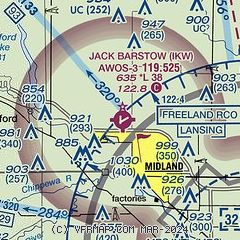
| Sectional chart |
|---|
|
| Airport distance calculator |
|---|
|
|
| Sunrise and sunset |
|---|
|
Times for 29-Jul-2026
| | Local
(UTC-4) | | Zulu
(UTC) |
|---|
| Morning civil twilight | | 05:51 | | 09:51 |
| Sunrise | | 06:24 | | 10:24 |
| Sunset | | 21:03 | | 01:03 |
| Evening civil twilight | | 21:36 | | 01:36 |
|
| Current date and time |
|---|
| Zulu (UTC) | 30-Jul-2026 02:21:32 |
|---|
| Local (UTC-4) | 29-Jul-2026 22:21:32 |
|---|
|
| METAR |
|---|
| KIKW | 300155Z AUTO 33003KT 10SM CLR 19/16 A2997 RMK AO2
|
KMBS
11nm SE | 300153Z 33007KT 10SM CLR 23/15 A2998 RMK AO2 SLP148 T02280150
|
|
| TAF |
|---|
KMBS
11nm SE | 291720Z 2918/3018 06010KT P6SM FEW060 FM300200 31005KT P6SM SKC
|
|
| NOTAMs |
|---|
NOTAMs are issued by the DoD/FAA and will open in a separate window not controlled by AirNav.
|
|

