FAA INFORMATION EFFECTIVE 14 MAY 2026
Location
| FAA Identifier: | INW |
| Lat/Long: | 35-01-18.8750N 110-43-21.0568W
35-01.314583N 110-43.350947W
35.0219097,-110.7225158
(estimated) |
| Elevation: | 4941.1 ft. / 1506.0 m (surveyed) |
| Variation: | 14E (1965) |
| From city: | 1 mile W of WINSLOW, AZ |
| Time zone: | UTC -7 (year round; does not observe DST) |
| Zip code: | 86047 |
Airport Operations
| Airport use: | Open to the public |
| Activation date: | 04/1940 |
| Control tower: | no |
| ARTCC: | ALBUQUERQUE CENTER |
| FSS: | PRESCOTT FLIGHT SERVICE STATION |
| NOTAMs facility: | INW (NOTAM-D service available) |
| Attendance: | MON-FRI 0700-1800, ALL SAT-SUN 0800-1700
AFT HR SVC - 928-587-2630. |
| Wind indicator: | lighted |
| Segmented circle: | yes
SEGMETED CIRCLE MISSING RWY 11 R TFC ARMS. |
| Lights: | ACTVT REIL RWY 11 & 22; MIRL RWY 04/22 & 11/29 - CTAF. VASI RWY 11 & 29 OPR CONSLY. |
| Beacon: | white-green (lighted land airport)
Operates sunset to sunrise. |
| Landing fee: | no, COML LNDG & OVNGT TIEDOWN FEE. |
Airport Communications
| CTAF/UNICOM: | 122.8 |
| WX ASOS: | 118.875 (928-224-5817) |
- APCH/DEP SVC PRVDD BY ALBUQUERQUE ARTCC (ZAB) ON FREQ 127.675/306.2 (WINSLOW RCAG).
Nearby radio navigation aids
| VOR radial/distance | | VOR name | | Freq | | Var |
|---|
| INWr110/4.3 | | WINSLOW VORTAC | | 112.60 | | 14E |
Airport Services
| Fuel available: | 100LL JET-A |
| Parking: | hangars and tiedowns |
Runway Information
Runway 4/22
| Dimensions: | 7499 x 150 ft. / 2286 x 46 m |
| Surface: | asphalt, in good condition |
| Weight bearing capacity: | | Single wheel: | 50.0 | | Double wheel: | 80.0 | | Double tandem: | 125.0 |
|
| Runway edge lights: | medium intensity |
| RUNWAY 4 | | RUNWAY 22 |
| Latitude: | 35-00.856000N | | 35-01.499867N |
| Longitude: | 110-44.272667W | | 110-42.990367W |
| Elevation: | 4941.1 ft. | | 4881.1 ft. |
| Traffic pattern: | left | | left |
| Runway heading: | 045 magnetic, 059 true | | 225 magnetic, 239 true |
| Displaced threshold: | no | | 1262 ft. |
| Declared distances: | LDA:7499 | | LDA:6236 |
| Markings: | nonprecision, in fair condition | | nonprecision, in fair condition |
| Visual slope indicator: | | | 4-box VASI on left (3.00 degrees glide path) |
| Runway end identifier lights: | no | | yes |
| Touchdown point: | yes, no lights | | yes, no lights |
| Obstructions: | none | | 18 ft. tree, 219 ft. from runway, 1:1 slope to clear
15 FT DITCH 15 FT FM RWY END ACRS THR. +12 FT TREES 10 FT FM THR 80 FT L OF CNTRLN. |
Runway 11/29
| Dimensions: | 7100 x 150 ft. / 2164 x 46 m |
| Surface: | asphalt, in fair condition
EDGES BOTH SIDES ROUGH WITH CRACKS & VEGETATION; CENTER PTN HAS LRG CRACKS & 4 IN HOLES. |
| Weight bearing capacity: | | Single wheel: | 60.0 | | Double wheel: | 70.0 | | Double tandem: | 110.0 |
|
| Runway edge lights: | medium intensity |
| Runway edge markings: | FADED. |
| RUNWAY 11 | | RUNWAY 29 |
| Latitude: | 35-01.748398N | | 35-01.169332N |
| Longitude: | 110-43.672648W | | 110-42.436708W |
| Elevation: | 4899.3 ft. | | 4870.0 ft. |
| Traffic pattern: | right | | left |
| Runway heading: | 106 magnetic, 120 true | | 286 magnetic, 300 true |
| Displaced threshold: | no | | 344 ft. |
| Declared distances: | LDA:7100 | | LDA:6756 |
| Markings: | nonprecision, in poor condition | | nonprecision, in poor condition |
| Visual slope indicator: | 4-box VASI on left (3.00 degrees glide path) | | 4-box VASI on left (3.00 degrees glide path) |
| Runway end identifier lights: | yes | | no |
| Touchdown point: | yes, no lights | | yes, no lights |
| Obstructions: | none
+4 FT BRUSH 0-200 FT FM THR 75-250 FT L & R OF CNTRLN. | | 8 ft. fence, 201 ft. from runway, 75 ft. right of centerline
8 FT FENCE 200 FT FM RWY END ACRS THR. 3 FT BRUSH 0-200 FT FM RWY END ACRS THR. |
Airport Ownership and Management from official FAA records
| Ownership: | Publicly-owned |
| Owner: | CITY OF WINSLOW
21 WILLIAMSON AVE
WINSLOW, AZ 86047
Phone 928-289-2422 |
| Manager: | TIM WESTOVER
21 WILLIAMSON AVE
WINSLOW, AZ 86047
Phone 928-289-2422
ORVILLE WISEMAN - 928-289-0100. |
Additional Remarks
| - | SW CORNER FOREST SVC RAMP CLSD. |
| - | FOR CD IF UNA TO CTC ON FSS FREQ, CTC ALBUQUERQUE ARTCC AT 505-856-4561. |
Instrument Procedures
NOTE: All procedures below are presented as PDF files. If you need a reader for these files, you should download the free Adobe Reader.NOT FOR NAVIGATION. Please procure official charts for flight.
FAA instrument procedures published for use from 14 May 2026 at 0901Z to 11 June 2026 at 0900Z.
IAPs - Instrument Approach Procedures |
|---|
| VOR OR GPS RWY 11 | |
download (200KB) |
| NOTE: Special Alternate Minimums apply | |
download (145KB) |
| NOTE: Special Take-Off Minimums/Departure Procedures apply | |
download |
Other nearby airports with instrument procedures:
KTYL - Taylor Airport (45 nm SE)
KFLG - Flagstaff Pulliam Airport (47 nm W)
KSEZ - Sedona Airport (53 nm W)
KPAN - Payson Airport (55 nm SW)
KSOW - Show Low Regional Airport (58 nm SE)
|
|

Road maps at:
MapQuest
Bing
Google
| Aerial photo |
|---|
WARNING: Photo may not be current or correct

Do you have a better or more recent aerial photo of Winslow-Lindbergh Regional Airport that you would like to share? If so, please send us your photo.
|
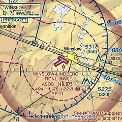
| Sectional chart |
|---|
|
CAUTION: Diagram may not be current

| Airport distance calculator |
|---|
|
|
| Sunrise and sunset |
|---|
|
Times for 01-Jun-2026
| | Local
(UTC-7) | | Zulu
(UTC) |
|---|
| Morning civil twilight | | 04:42 | | 11:42 |
| Sunrise | | 05:11 | | 12:11 |
| Sunset | | 19:30 | | 02:30 |
| Evening civil twilight | | 20:00 | | 03:00 |
|
| Current date and time |
|---|
| Zulu (UTC) | 01-Jun-2026 07:59:35 |
|---|
| Local (UTC-7) | 01-Jun-2026 00:59:35 |
|---|
|
| METAR |
|---|
| KINW | 010656Z AUTO 22009KT 10SM CLR 18/M04 A3004 RMK AO2 SLP105 T01781044 403060072 $
|
|
| TAF |
|---|
| KINW | 010520Z 0106/0206 23008G15KT P6SM SKC FM011000 12005KT P6SM SKC FM011500 VRB06KT P6SM FEW250 FM020100 23008G16KT P6SM SCT250
|
|
| NOTAMs |
|---|
NOTAMs are issued by the DoD/FAA and will open in a separate window not controlled by AirNav.
|
|


