FAA INFORMATION EFFECTIVE 22 JANUARY 2026
Location
| FAA Identifier: | SEZ |
| Lat/Long: | 34-50-54.9210N 111-47-18.4110W
34-50.915350N 111-47.306850W
34.8485892,-111.7884475
(estimated) |
| Elevation: | 4830.5 ft. / 1472.3 m (surveyed) |
| Variation: | 13E (1985) |
| From city: | 2 miles SW of SEDONA, AZ |
| Time zone: | UTC -7 (year round; does not observe DST) |
| Zip code: | 86336 |
Airport Operations
| Airport use: | Open to the public |
| Activation date: | 05/1956 |
| Control tower: | no |
| ARTCC: | ALBUQUERQUE CENTER |
| FSS: | PRESCOTT FLIGHT SERVICE STATION |
| NOTAMs facility: | SEZ (NOTAM-D service available) |
| Attendance: | MAY-SEP 0700-1800, OCT-APR 0700-2000 |
| Pattern altitude: | TPA FOR PROPELLER ACFT 1173 AGL, JET ACFT 2173 AGL. |
| Wind indicator: | lighted |
| Segmented circle: | yes |
| Lights: | ACTVT REIL RWY 03 & 21; PAPI RWY 03 & 21; MIRL RWY 03/21 - CTAF. |
| Beacon: | white-green (lighted land airport)
Operates sunset to sunrise. |
| Landing fee: | yes |
Airport Communications
| CTAF/UNICOM: | 123.0 |
| WX AWOS-3PT: | 118.525 (928-282-1993) |
| PHOENIX APPROACH: | 126.375 |
| PHOENIX DEPARTURE: | 126.375 |
| WX AWOS-3 at P52 (14 nm SW): | 119.925 (928-634-0916) |
| WX ASOS at FLG (18 nm N): | 125.8 (928-216-3910) |
- COMMUNICATIONS PRVDD BY PRESCOTT RADIO ON FREQ 122.3 (COTTONWOOD RCO).
Nearby radio navigation aids
| VOR radial/distance | | VOR name | | Freq | | Var |
|---|
| FLGr183/18.8 | | FLAGSTAFF VOR/DME | | 113.85 | | 14E |
| DRKr062/35.2 | | DRAKE VORTAC | | 114.10 | | 14E |
Airport Services
| Fuel available: | 100LL JET-A
A:10 PCT SHF.
100LL:AFT HR CALL OUT FEE. |
| Parking: | tiedowns |
| Airframe service: | MINOR |
| Powerplant service: | MINOR |
Runway Information
Runway 3/21
| Dimensions: | 5132 x 100 ft. / 1564 x 30 m |
| Surface: | asphalt, in good condition |
| Weight bearing capacity: | | Single wheel: | 15.0 | | Double wheel: | 30.0 |
|
| Runway edge lights: | medium intensity |
| Operational restrictions: | RWY 03 CALM WIND RWY FOR LNDG; RWY 21 FOR TKOFF. |
| RUNWAY 3 | | RUNWAY 21 |
| Latitude: | 34-50.620352N | | 34-51.210343N |
| Longitude: | 111-47.674313W | | 111-46.939327W |
| Elevation: | 4736.3 ft. | | 4830.3 ft. |
| Traffic pattern: | left | | left |
| Runway heading: | 032 magnetic, 045 true | | 212 magnetic, 225 true |
| Markings: | nonprecision, in good condition | | basic, in good condition |
| Visual slope indicator: | 4-light PAPI on left (3.00 degrees glide path) | | 4-light PAPI on left (3.50 degrees glide path)
PAPI UNUSBL BYD 2.0 NM. |
| Runway end identifier lights: | yes | | yes |
| Touchdown point: | yes, no lights | | yes, no lights |
| Obstructions: | none
1 FT FENCE POST 125 FT FM THR 75 FT L OF CNTRLN LGTD SS-SR. | | 8 ft. fence, 201 ft. from runway, 70 ft. left of centerline
8 FT FENCE 100-200 FT FM THR 90-125 FT L OF CNTRLN LGTD SS-SR. |
Helipad H1
| Dimensions: | 50 x 50 ft. / 15 x 15 m |
| Surface: | concrete, in good condition |
| Runway edge lights: | FLD |
| Latitude: | 34-50.818500N | | |
| Longitude: | 111-47.549500W | | |
| Elevation: | 4757.0 ft. | | |
| Traffic pattern: | left | | left |
Airport Ownership and Management from official FAA records
| Ownership: | Publicly-owned |
| Owner: | YAVAPAI COUNTY
1015 FAIR ST.
PRESCOTT, AZ 86305
Phone (928) 771-3200 |
| Manager: | EDWARD A. ROSE
235 AIR TERMINAL DRIVE
SEDONA, AZ 86336
Phone 928-282-4487
EMERG 928-300-3304. |
Additional Remarks
| - | ARPT ON 500 FT MESA; WS, TURB, UP & DOWN DRAFTS NEAR MESA EDGE. |
| - | BIRDS & WILDLIFE ON & INVOF ARPT. |
| - | FOR CD CTC PHOENIX APCH AT 602-306-2565. |
| - | OVNGT TSNT FEE. |
| - | HOP FM HELI S & W OF RWY; HOP RSTRD TO HELI ADJ TO TWY INTXN A7 SW MAIN TRML BLDG. |
| - | NOISE ABATEMENT PROC IN EFCT; SCENIC FLT BLW 6500 FT MSL NA. |
Instrument Procedures
NOTE: All procedures below are presented as PDF files. If you need a reader for these files, you should download the free Adobe Reader.NOT FOR NAVIGATION. Please procure official charts for flight.
FAA instrument procedures published for use from 22 January 2026 at 0901Z to 19 February 2026 at 0900z.
IAPs - Instrument Approach Procedures |
|---|
| RNAV (GPS) RWY 03 | |
download (237KB) |
| NOTE: Special Alternate Minimums apply | |
download (141KB) |
|
|---|
| BYTER ONE (OBSTACLE) (RNAV) | |
download (181KB) |
| NOTE: Special Take-Off Minimums/Departure Procedures apply | |
download (382KB) |
Other nearby airports with instrument procedures:
P52 - Cottonwood Airport (14 nm SW)
KFLG - Flagstaff Pulliam Airport (18 nm N)
KPRC - Prescott Regional/Ernest A Love Field Airport (33 nm W)
KCMR - H A Clark Memorial Field Airport (34 nm NW)
KPAN - Payson Airport (42 nm SE)
|
|

Road maps at:
MapQuest
Bing
Google
| Aerial photo |
|---|
WARNING: Photo may not be current or correct
 Photo by Andreas Lauschke
Photo taken 07-Dec-2024
looking northeast.
Photo by Andreas Lauschke
Photo taken 07-Dec-2024
looking northeast.
Do you have a better or more recent aerial photo of Sedona Airport that you would like to share? If so, please send us your photo.
|
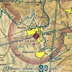
| Sectional chart |
|---|
|
| Airport distance calculator |
|---|
|
|
| Sunrise and sunset |
|---|
|
Times for 16-Feb-2026
| | Local
(UTC-7) | | Zulu
(UTC) |
|---|
| Morning civil twilight | | 06:47 | | 13:47 |
| Sunrise | | 07:13 | | 14:13 |
| Sunset | | 18:10 | | 01:10 |
| Evening civil twilight | | 18:36 | | 01:36 |
|
| Current date and time |
|---|
| Zulu (UTC) | 16-Feb-2026 09:01:02 |
|---|
| Local (UTC-7) | 16-Feb-2026 02:01:02 |
|---|
|
| METAR |
|---|
| KSEZ | 160835Z AUTO 00000KT 10SM CLR 11/00 A2999 RMK AO2
|
KFLG
18nm N | 160757Z AUTO 22004KT 10SM CLR 02/M02 A3002 RMK AO2 SLP118 T00221022 $
|
|
| TAF |
|---|
| KSEZ | 160530Z 1606/1706 VRB06KT P6SM BKN250 FM161800 16015G25KT P6SM SCT150 BKN250 FM170100 17021G33KT P6SM VCSH SCT020 BKN050 PROB30 1703/1706 5SM -SHRA OVC020
|
KFLG
18nm N | 160530Z 1606/1706 22006KT P6SM BKN250 FM161600 22014G25KT P6SM SCT150 BKN250 FM161900 21025G38KT P6SM SCT100 BKN200 FM170100 21026G40KT P6SM VCSH SCT015 BKN050 PROB30 1702/1706 3SM -SHSN OVC015
|
|
| NOTAMs |
|---|
NOTAMs are issued by the DoD/FAA and will open in a separate window not controlled by AirNav.
|
|


