FAA INFORMATION EFFECTIVE 27 NOVEMBER 2025
Location
| FAA Identifier: | IPT |
| Lat/Long: | 41-14-30.0000N 076-55-18.5000W
41-14.500000N 076-55.308333W
41.2416667,-76.9218056
(estimated) |
| Elevation: | 528.1 ft. / 161.0 m (surveyed) |
| Variation: | 10W (1980) |
| From city: | 4 miles E of WILLIAMSPORT, PA |
| Time zone: | UTC -5 (UTC -4 during Daylight Saving Time) |
| Zip code: | 17754 |
Airport Operations
| Airport use: | Open to the public |
| Activation date: | 04/1938 |
| Control tower: | yes |
| ARTCC: | NEW YORK CENTER |
| FSS: | WILLIAMSPORT FLIGHT SERVICE STATION |
| NOTAMs facility: | IPT (NOTAM-D service available) |
| Attendance: | MON-FRI 0430-2000, ALL SAT-SUN 0700-2000 |
| Wind indicator: | lighted |
| Segmented circle: | yes |
| Lights: | DUSK-DAWN. WHEN ATCT CLSD ACTVT MALSR RWY 27; REIL RWY 09; HIRL RWY 09/27; MIRL RWY 12/30; AND TWY LGTS - CTAF. PAPI RWYS 09, 12 & 30 OPER CONSLY. MIRL RWY 12/30, CLICK THREE TIMES FOR MEDIUM INTST. |
| Beacon: | white-green (lighted land airport)
Operates sunset to sunrise. |
| Landing fee: | yes |
| Fire and rescue: | ARFF index A |
| Airline operations: | PPR 12 HRS FOR UNSKED ACR OPNS WITH MORE THAN 30 PSGR SEATS CALL AMGR. INDEX A COVERAGE AVBL 0700-1700 AND BTN 1700-0700 UPON REQ CALL AMGR. INDEX B COVERAGE AVBL UPON REQ CALL AMGR. |
Airport Communications
| CTAF: | 119.1 |
| UNICOM: | 122.95 |
| WX ASOS: | 125.225 (570-360-5258) |
| WILLIAMSPORT GROUND: | 121.9 [0630-2230] |
| WILLIAMSPORT TOWER: | 119.1 257.8 [0630-2230] |
| EMERG: | 121.5 243.0 |
- APCH/DEP SVC PRVDD BY NEW YORK ARTCC ON FREQ 124.9 (WILLIAMSPORT RCAG).
- WHEN ATCT CLSD NEW YORK ARTCC PROVIDES CLNC DEL ON FREQ 124.9.
- COMMUNICATIONS PRVDD BY WILLIAMSPORT RADIO ON FREQ 122.2 (WILLIAMSPORT RCO).
Nearby radio navigation aids
| VOR radial/distance | | VOR name | | Freq | | Var |
|---|
| FQMr238/8.8 | | WILLIAMSPORT VOR/DME | | 114.40 | | 09W |
| MIPr327/17.5 | | MILTON VORTAC | | 109.20 | | 09W |
| SEGr004/27.1 | | SELINSGROVE VOR/DME | | 110.40 | | 08W |
| SFKr149/35.2 | | STONYFORK VOR/DME | | 108.60 | | 08W |
Airport Services
| Fuel available: | 100LL JET-A
100LL:FUEL & SVCS AVBL 0700-2200 DLY; AFTER HRS BY PRIOR CDN CALL 570-368-2651. |
| Parking: | hangars and tiedowns |
| Airframe service: | MAJOR |
| Powerplant service: | MAJOR |
| Bottled oxygen: | NONE |
| Bulk oxygen: | HIGH |
Runway Information
Runway 9/27
| Dimensions: | 6825 x 150 ft. / 2080 x 46 m |
| Surface: | asphalt/grooved, in good condition |
| Weight bearing capacity: | | Single wheel: | 65.0 | | Double wheel: | 100.0 | | Double tandem: | 190.0 |
|
| Runway edge lights: | high intensity |
| RUNWAY 9 | | RUNWAY 27 |
| Latitude: | 41-14.306208N | | 41-14.559860N |
| Longitude: | 076-56.139005W | | 076-54.688622W |
| Elevation: | 513.8 ft. | | 525.2 ft. |
| Traffic pattern: | left | | right |
| Runway heading: | 087 magnetic, 077 true | | 267 magnetic, 257 true |
| Displaced threshold: | no | | 255 ft. |
| Declared distances: | TORA:6825 TODA:6825 ASDA:6073 LDA:6073 | | TORA:6825 TODA:6825 ASDA:6318 LDA:6063 |
| Markings: | precision, in fair condition | | precision, in fair condition |
| Visual slope indicator: | 4-light PAPI on left (3.00 degrees glide path)
RWY 09 PAPI BAFFLED UNUSBL BYD 2 DEGS R OF CRS. | | |
| Approach lights: | | | MALSR: 1,400 foot medium intensity approach lighting system with runway alignment indicator lights |
| Runway end identifier lights: | yes | | |
| Touchdown point: | yes, no lights | | yes, no lights |
| Instrument approach: | | | ILS/DME |
| Obstructions: | 62 ft. trees, 657 ft. from runway, 441 ft. left of centerline, 7:1 slope to clear
16:1 TO DSPLCD THLD. | | 77 ft. trees, 955 ft. from runway, 552 ft. left of centerline, 9:1 slope to clear |
Runway 12/30
| Dimensions: | 4273 x 150 ft. / 1302 x 46 m |
| Surface: | asphalt, in good condition |
| Weight bearing capacity: | | Single wheel: | 200.0 | | Double wheel: | 200.0 | | Double tandem: | 400.0 |
|
| Runway edge lights: | medium intensity |
| RUNWAY 12 | | RUNWAY 30 |
| Latitude: | 41-14.702353N | | 41-14.508483N |
| Longitude: | 076-55.589802W | | 076-54.693610W |
| Elevation: | 523.0 ft. | | 525.6 ft. |
| Traffic pattern: | left | | right |
| Runway heading: | 116 magnetic, 106 true | | 296 magnetic, 286 true |
| Declared distances: | TORA:4273 TODA:4273 ASDA:4273 LDA:4273 | | TORA:4273 TODA:4273 ASDA:4273 LDA:4273 |
| Markings: | nonprecision, in fair condition | | nonprecision, in fair condition |
| Visual slope indicator: | 2-light PAPI on left (3.75 degrees glide path) | | 2-light PAPI on left (4.00 degrees glide path)
RWY 30 PAPI BAFFLED UNUSBL BYD 7 DEGS L OF CRS. |
| Touchdown point: | yes, no lights | | yes, no lights |
| Obstructions: | 97 ft. trees, 2002 ft. from runway, 511 ft. left of centerline, 18:1 slope to clear | | 32 ft. trees, 334 ft. from runway, 263 ft. left of centerline, 4:1 slope to clear |
Airport Ownership and Management from official FAA records
| Ownership: | Publicly-owned |
| Owner: | WILLIAMSPORT MUNI ARPT AUTH
724 AIRPORT RD
MONTOURSVILLE, PA 17754
Phone 570-368-2444 |
| Manager: | ERIC MCKITISH
724 AIRPORT RD
MONTOURSVILLE, PA 17754
Phone 570-368-2444 |
Additional Remarks
| A39-12/30 | PCR VALUE: 2230/F/C/X/T |
| A39-09/27 | PCR VALUE: 690/F/A/X/T |
| - | DEER & BIRDS ON & INVOF ARPT SPCLY AER 27 & AER 30 |
| - | TWY 'J' CLSD TO ACFT WITH WING SPAN OVER 78 FT. |
| - | FOR LANDSIDE ACCESS FM ARPT AFTER HRS USE COMPUTERIZED GATE SYSTEM AT EAST END OR FBO APRON. |
| - | UNLGTD CRANE 90 FT AGL .5 MI SE AER 30 PERMLY. |
| - | COLD TEMPERATURE AIRPORT. ALTITUDE CORRECTION REQUIRED AT OR BELOW -13C. |
| - | FOR CD IF UNA TO CTC ON FSS FREQ, CTC NEW YORK ARTCC AT 631-468-1425. |
| - | RWY & TWY CONDS NOT MNT DLY 1700-0700. |
Instrument Procedures
NOTE: All procedures below are presented as PDF files. If you need a reader for these files, you should download the free Adobe Reader.NOT FOR NAVIGATION. Please procure official charts for flight.
FAA instrument procedures published for use from 27 November 2025 at 0901Z to 25 December 2025 at 0900Z.
IAPs - Instrument Approach Procedures |
|---|
| ILS OR LOC RWY 27 | |
download (258KB) |
| RNAV (GPS) RWY 09 | |
download (230KB) |
| RNAV (GPS) RWY 12 | |
download (226KB) |
| RNAV (GPS) RWY 27 | |
download (260KB) |
| RNAV (GPS) RWY 30 | |
download (208KB) |
| NOTE: Special Alternate Minimums apply | |
download (67KB) |
| NOTE: Special Take-Off Minimums/Departure Procedures apply | |
download (260KB) |
Other nearby airports with instrument procedures:
8N8 - Danville Airport (22 nm SE)
KLHV - William T Piper Memorial Airport (23 nm W)
KSEG - Penn Valley Airport (25 nm S)
N13 - Bloomsburg Municipal Airport (26 nm SE)
N79 - Northumberland County Airport (29 nm SE)
|
|

Road maps at:
MapQuest
Bing
Google
| Aerial photo |
|---|
WARNING: Photo may not be current or correct
 Photo by Joseph J. Trombino
Photo taken 30-Apr-2018
looking west.
Photo by Joseph J. Trombino
Photo taken 30-Apr-2018
looking west.
Do you have a better or more recent aerial photo of Williamsport Regional Airport that you would like to share? If so, please send us your photo.
|
| Sectional chart |
|---|
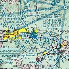
|
 Download PDF
of official airport diagram from the FAA
| Airport distance calculator |
|---|
|
|
| Sunrise and sunset |
|---|
|
Times for 05-Dec-2025
| | Local
(UTC-5) | | Zulu
(UTC) |
|---|
| Morning civil twilight | | 06:48 | | 11:48 |
| Sunrise | | 07:19 | | 12:19 |
| Sunset | | 16:38 | | 21:38 |
| Evening civil twilight | | 17:09 | | 22:09 |
|
| Current date and time |
|---|
| Zulu (UTC) | 06-Dec-2025 02:17:51 |
|---|
| Local (UTC-5) | 05-Dec-2025 21:17:51 |
|---|
|
| METAR |
|---|
| KIPT | 060154Z 08004KT 10SM OVC045 M04/M09 A3001 RMK AO2 SLP170 T10441094
|
|
| TAF |
|---|
| KIPT | 051740Z 0518/0618 09007KT P6SM OVC040 FM051900 10006KT P6SM OVC035 FM052200 11003KT P6SM OVC025 FM060200 00000KT P6SM FEW008 OVC012 FM061600 24005KT P6SM OVC050
|
|
| NOTAMs |
|---|
NOTAMs are issued by the DoD/FAA and will open in a separate window not controlled by AirNav.
|
|


