FAA INFORMATION EFFECTIVE 25 DECEMBER 2025
Location
| FAA Identifier: | IRK |
| Lat/Long: | 40-05-36.5000N 092-32-41.7000W
40-05.608333N 092-32.695000W
40.0934722,-92.5449167
(estimated) |
| Elevation: | 966.3 ft. / 294.5 m (surveyed) |
| Variation: | 03E (1990) |
| From city: | 6 miles SE of KIRKSVILLE, MO |
| Time zone: | UTC -6 (UTC -5 during Daylight Saving Time) |
| Zip code: | 63501 |
Airport Operations
| Airport use: | Open to the public |
| Activation date: | 05/1941 |
| Control tower: | no |
| ARTCC: | KANSAS CITY CENTER |
| FSS: | COLUMBIA FLIGHT SERVICE STATION |
| NOTAMs facility: | IRK (NOTAM-D service available) |
| Attendance: | 0530-2000 |
| Wind indicator: | lighted |
| Segmented circle: | yes |
| Lights: | ACTVT HIRL RY 18/36; VASI RYS 18 & 36; REIL RY 18 & MALSR RY 36 - CTAF. |
| Beacon: | white-green (lighted land airport)
Operates sunset to sunrise. |
| Fire and rescue: | ARFF index A |
Airport Communications
| CTAF/UNICOM: | 122.8 |
| WX ASOS: | 121.125 (660-202-8736) |
- COMMUNICATIONS PRVDD BY COLUMBIA RADIO ON FREQ 122.2 (KIRKSVILLE RCO).
- APCH/DEP SVC PRVDD BY KANSAS CITY ARTCC ON FREQS 132.6/370.9 (KIRKSVILLE RCAG).
Nearby radio navigation aids
| VOR radial/distance | | VOR name | | Freq | | Var |
|---|
| IRKr133/3.3 | | KIRKSVILLE VORTAC | | 114.60 | | 06E |
Airport Services
| Fuel available: | 100LL JET-A |
| Parking: | hangars and tiedowns |
| Airframe service: | MAJOR |
| Powerplant service: | MAJOR |
| Bottled oxygen: | NONE |
| Bulk oxygen: | NONE |
Runway Information
Runway 18/36
| Dimensions: | 6005 x 100 ft. / 1830 x 30 m |
| Surface: | concrete, in fair condition |
| Weight bearing capacity: | | PCN 10 /R/D/W/T | | Single wheel: | 30.0 | | Double wheel: | 48.0 | | Double tandem: | 85.0 |
|
| Runway edge lights: | high intensity |
| RUNWAY 18 | | RUNWAY 36 |
| Latitude: | 40-06.043948N | | 40-05.055055N |
| Longitude: | 092-32.652028W | | 092-32.662972W |
| Elevation: | 966.2 ft. | | 963.7 ft. |
| Traffic pattern: | left | | left |
| Runway heading: | 177 magnetic, 180 true | | 357 magnetic, 000 true |
| Declared distances: | TORA:6005 TODA:6005 ASDA:6005 LDA:6005 | | TORA:6005 TODA:6005 ASDA:6005 LDA:6005 |
| Markings: | nonprecision, in fair condition | | precision, in fair condition |
| Visual slope indicator: | 4-box VASI on left (3.00 degrees glide path) | | 4-box VASI on left (3.00 degrees glide path) |
| Approach lights: | | | MALSR: 1,400 foot medium intensity approach lighting system with runway alignment indicator lights |
| Runway end identifier lights: | yes | | |
| Touchdown point: | yes, no lights | | yes, no lights |
| Instrument approach: | | | ILS/DME |
Runway 9/27
| Dimensions: | 1370 x 100 ft. / 418 x 30 m |
| Surface: | turf, in good condition |
| Runway edge markings: | 09/27 MARKED WITH YELLOW CONES. |
| Operational restrictions: | RWY 09/27 NOT AVBL FOR PART 121/PART 380 OPS WITH SKED PAX CARRYING OPS MORE THAN 9 PAX SEATS AND NON-SKED PAX CARRYING OPS MORE THAN 30 PAX SEATS. |
| RUNWAY 9 | | RUNWAY 27 |
| Latitude: | 40-05.868265N | | 40-05.865512N |
| Longitude: | 092-33.004853W | | 092-32.711072W |
| Elevation: | 959.0 ft. | | 964.2 ft. |
| Traffic pattern: | left | | left |
| Runway heading: | 088 magnetic, 091 true | | 268 magnetic, 271 true |
| Touchdown point: | yes, no lights | | yes, no lights |
| Obstructions: | 72 ft. trees, 1440 ft. from runway, 20:1 slope to clear | | 47 ft. trees, 1240 ft. from runway, 26:1 slope to clear |
Airport Ownership and Management from official FAA records
| Ownership: | Publicly-owned |
| Owner: | CITY OF KIRKSVILLE
CITY HALL, 201 SOUTH FRANKLIN
KIRKSVILLE, MO 63501
Phone 660-627-1225 |
| Manager: | JEFFERY LAFOUNTAIN
27161 DAVID HALL TRAIL
KIRKSVILLE, MO 63501
Phone 660-665-5020
AIRPORT DIRECTOR |
Additional Remarks
| - | FOR CD IF UNA TO CTC ON FSS FREQ, CTC KANSAS CITY ARTCC AT 913-254-8508. |
Instrument Procedures
NOTE: All procedures below are presented as PDF files. If you need a reader for these files, you should download the free Adobe Reader.NOT FOR NAVIGATION. Please procure official charts for flight.
FAA instrument procedures published for use from 25 December 2025 at 0901z to 22 January 2026 at 0900z.
IAPs - Instrument Approach Procedures |
|---|
| ILS OR LOC RWY 36 | |
download (195KB) |
| RNAV (GPS) RWY 18 | |
download (200KB) |
| RNAV (GPS) RWY 36 | |
download (204KB) |
| VOR-A | |
download (164KB) |
| NOTE: Special Alternate Minimums apply | |
download (124KB) |
| NOTE: Special Take-Off Minimums/Departure Procedures apply | |
download (158KB) |
Other nearby airports with instrument procedures:
K89 - Macon-Fower Memorial Airport (22 nm S)
03D - Memphis Memorial Airport (26 nm NE)
MO8 - North Central Missouri Regional Airport (29 nm SW)
KMBY - Omar N Bradley Airport (38 nm S)
4K6 - Bloomfield Municipal Airport (39 nm N)
|
|

Road maps at:
MapQuest
Bing
Google
| Aerial photo |
|---|
WARNING: Photo may not be current or correct
 Taken in October 2005
Do you have a better or more recent aerial photo of Kirksville Regional Airport that you would like to share? If so, please send us your photo.
|
| Sectional chart |
|---|
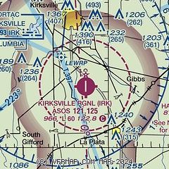
|
 Download PDF
of official airport diagram from the FAA
| Airport distance calculator |
|---|
|
|
| Sunrise and sunset |
|---|
|
Times for 06-Jan-2026
| | Local
(UTC-6) | | Zulu
(UTC) |
|---|
| Morning civil twilight | | 07:03 | | 13:03 |
| Sunrise | | 07:34 | | 13:34 |
| Sunset | | 16:59 | | 22:59 |
| Evening civil twilight | | 17:29 | | 23:29 |
|
| Current date and time |
|---|
| Zulu (UTC) | 06-Jan-2026 19:43:10 |
|---|
| Local (UTC-6) | 06-Jan-2026 13:43:10 |
|---|
|
| METAR |
|---|
| KIRK | 061855Z AUTO 26012KT 8SM OVC005 04/04 A2972 RMK AO2 SLP074 T00440039 $
|
|
| NOTAMs |
|---|
NOTAMs are issued by the DoD/FAA and will open in a separate window not controlled by AirNav.
|
|


