FAA INFORMATION EFFECTIVE 17 APRIL 2025
Location
| FAA Identifier: | 4K6 |
| Lat/Long: | 40-43-55.5800N 092-25-41.7680W
40-43.926333N 092-25.696133W
40.7321056,-92.4282689
(estimated) |
| Elevation: | 888 ft. / 270.7 m (surveyed) |
| Variation: | 02E (2000) |
| From city: | 2 miles SW of BLOOMFIELD, IA |
| Time zone: | UTC -5 (UTC -6 during Standard Time) |
| Zip code: | 52537 |
Airport Operations
| Airport use: | Open to the public |
| Activation date: | 09/1961 |
| Control tower: | no |
| ARTCC: | CHICAGO CENTER |
| FSS: | FORT DODGE FLIGHT SERVICE STATION |
| NOTAMs facility: | FOD (NOTAM-D service available) |
| Attendance: | MON-FRI 0830-1730, ALL SAT 0900-1200 |
| Wind indicator: | lighted |
| Segmented circle: | no |
| Lights: | ACTVT MIRL RY 18/36 - CTAF. |
| Beacon: | white-green (lighted land airport)
Operates sunset to sunrise. |
Airport Communications
- APCH/DEP SVC PRVDD BY CHICAGO ARTCC ON FREQS 118.15/335.575 (OTTUMWA RCAG).
Nearby radio navigation aids
| VOR radial/distance | | VOR name | | Freq | | Var |
|---|
| IRKr006/36.6 | | KIRKSVILLE VORTAC | | 114.60 | | 06E |
Airport Services
| Fuel available: | 100LL |
| Parking: | hangars and tiedowns |
| Airframe service: | MAJOR |
| Powerplant service: | MAJOR |
| Bottled oxygen: | NONE |
| Bulk oxygen: | NONE |
Runway Information
Runway 18/36
| Dimensions: | 3401 x 60 ft. / 1037 x 18 m |
| Surface: | concrete, in good condition |
| Weight bearing capacity: | | PCN 6 /R/C/W/T | | Single wheel: | 28.0 | | Double wheel: | 20.0 |
|
| Runway edge lights: | medium intensity |
| RUNWAY 18 | | RUNWAY 36 |
| Latitude: | 40-44.205800N | | 40-43.645733N |
| Longitude: | 092-25.700167W | | 092-25.693200W |
| Elevation: | 883.0 ft. | | 888.0 ft. |
| Traffic pattern: | left | | left |
| Runway heading: | 177 magnetic, 179 true | | 357 magnetic, 359 true |
| Markings: | nonprecision, in good condition | | nonprecision, in good condition |
| Visual slope indicator: | 2-light PAPI on left (3.00 degrees glide path) | | 2-light PAPI on left (3.00 degrees glide path) |
| Touchdown point: | yes, no lights | | yes, no lights |
| Obstructions: | 58 ft. tree, 801 ft. from runway, 182 ft. right of centerline, 10:1 slope to clear | | 22 ft. trees, 732 ft. from runway, 114 ft. right of centerline, 24:1 slope to clear |
Airport Ownership and Management from official FAA records
| Ownership: | Publicly-owned |
| Owner: | CITY OF BLOOMFIELD
111 W FRANKLIN ST
BLOOMFIELD, IA 52537
Phone 641-664-2260 |
| Manager: | CHARLES A. SPARGUR
MUNI ARPT 20956 230TH ST
BLOOMFIELD, IA 52537
Phone 641-664-1255
TONY |
Additional Remarks
| - | FOR SVC AFTER HRS CALL 641-208-6709. |
| - | FOR CD CTC CHICAGO ARTCC AT 630-906-8921. |
Instrument Procedures
NOTE: All procedures below are presented as PDF files. If you need a reader for these files, you should download the free Adobe Reader.NOT FOR NAVIGATION. Please procure official charts for flight.
FAA instrument procedures published for use from 17 April 2025 at 0901Z to 15 May 2025 at 0900z.
IAPs - Instrument Approach Procedures |
|---|
| RNAV (GPS) RWY 36 | |
download (185KB) |
| NOTE: Special Take-Off Minimums/Departure Procedures apply | |
download (426KB) |
Other nearby airports with instrument procedures:
03D - Memphis Memorial Airport (19 nm SE)
KTVK - Centerville Municipal Airport (22 nm W)
4C8 - Albia Municipal Airport (22 nm NW)
KOTM - Ottumwa Regional Airport (23 nm N)
KFFL - Fairfield Municipal Airport (28 nm NE)
|
|

Road maps at:
MapQuest
Bing
Google
| Aerial photo |
|---|

|
| Sectional chart |
|---|
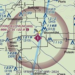
|
| Airport distance calculator |
|---|
|
|
| Sunrise and sunset |
|---|
|
Times for 04-May-2025
| | Local
(UTC-5) | | Zulu
(UTC) |
|---|
| Morning civil twilight | | 05:35 | | 10:35 |
| Sunrise | | 06:05 | | 11:05 |
| Sunset | | 20:08 | | 01:08 |
| Evening civil twilight | | 20:38 | | 01:38 |
|
| Current date and time |
|---|
| Zulu (UTC) | 04-May-2025 12:51:21 |
|---|
| Local (UTC-5) | 04-May-2025 07:51:21 |
|---|
|
| METAR |
|---|
KTVK
22nm W | 041235Z AUTO 31006KT 10SM CLR 09/07 A3006 RMK AO2
|
KOTM
22nm N | 041153Z AUTO 30005KT 6SM BR CLR 06/06 A3003 RMK AO2 SLP171 T00610056 10061 20028 53007
|
KFFL
28nm NE | 041235Z AUTO 33007KT 10SM CLR 09/09 A3004 RMK A01
|
KOOA
30nm N | 041235Z AUTO 32006KT 10SM CLR 09/07 A3006 RMK AO2 T00880074
|
KIRK
38nm S | 041155Z AUTO 32005KT 10SM CLR 06/05 A3004 RMK AO2 SLP177 T00560050 10072 20028 53005 $
|
|
| TAF |
|---|
KOTM
22nm N | 041130Z 0412/0512 29003KT 5SM BR SKC FM041300 33005KT P6SM SCT220 FM041800 02007KT P6SM FEW060 SCT220
|
|
| NOTAMs |
|---|
NOTAMs are issued by the DoD/FAA and will open in a separate window not controlled by AirNav.
|
|


