FAA INFORMATION EFFECTIVE 22 JANUARY 2026
Location
| FAA Identifier: | IWD |
| Lat/Long: | 46-31-38.9330N 090-07-53.0200W
46-31.648883N 090-07.883667W
46.5274814,-90.1313944
(estimated) |
| Elevation: | 1230.3 ft. / 375.0 m (surveyed) |
| Variation: | 00E (1985) |
| From city: | 7 miles NE of IRONWOOD, MI |
| Time zone: | UTC -6 (UTC -5 during Daylight Saving Time) |
| Zip code: | 49938 |
Airport Operations
| Airport use: | Open to the public |
| Activation date: | 04/1940 |
| Control tower: | no |
| ARTCC: | MINNEAPOLIS CENTER |
| FSS: | GREEN BAY FLIGHT SERVICE STATION |
| NOTAMs facility: | IWD (NOTAM-D service available) |
| Attendance: | 0500-2100 |
| Wind indicator: | lighted |
| Segmented circle: | yes |
| Lights: | ACTVT MALSR RWY 27; REIL RWY 09; PAPI RWY 09; HIRL RWY 09/27 - CTAF. |
| Beacon: | white-green (lighted land airport)
Operates sunset to sunrise. |
| Landing fee: | yes, WAIVED WITH FUEL PURCHASE. |
| Fire and rescue: | ARFF index A |
| Airline operations: | ARPT CLSD TO UNSKED ACR OPS GTR THAN 30 PAX SEATS EXC 48 HR PPR CALL AMGR. |
Airport Communications
| CTAF/UNICOM: | 122.8 |
| WX AWOS-3PT: | 125.175 (906-932-4039) |
- APCH/DEP SVC PRVDD BY MINNEAPOLIS ARTCC ON FREQ 133.55 (IRONWOOD RCAG).
- COMMUNICATIONS PRVDD BY GREEN BAY RADIO ON FREQ 122.3 (IRONWOOD RCO).
Nearby radio navigation aids
| VOR radial/distance | | VOR name | | Freq | | Var |
|---|
| IWD at field | | IRONWOOD VOR/DME | | 108.80 | | 01E |
Airport Services
| Fuel available: | 100LL JET-A |
| Parking: | hangars and tiedowns |
| Bottled oxygen: | NONE |
| Bulk oxygen: | NONE |
Runway Information
Runway 9/27
| Dimensions: | 6502 x 100 ft. / 1982 x 30 m |
| Surface: | asphalt/grooved, in excellent condition |
| Weight bearing capacity: | | Single wheel: | 85.0 | | Double wheel: | 150.0 | | Double tandem: | 280.0 |
|
| Runway edge lights: | high intensity |
| RUNWAY 9 | | RUNWAY 27 |
| Latitude: | 46-31.650760N | | 46-31.646928N |
| Longitude: | 090-08.658542W | | 090-07.108798W |
| Elevation: | 1222.9 ft. | | 1230.1 ft. |
| Traffic pattern: | left | | left |
| Runway heading: | 090 | | 270 |
| Declared distances: | TORA:6501 TODA:6501 ASDA:6501 LDA:6501 | | TORA:6501 TODA:6501 ASDA:6501 LDA:6501 |
| Markings: | precision, in good condition | | precision, in good condition |
| Visual slope indicator: | 4-light PAPI on left (3.00 degrees glide path) | | |
| Approach lights: | | | MALSR: 1,400 foot medium intensity approach lighting system with runway alignment indicator lights |
| Runway end identifier lights: | yes | | |
| Touchdown point: | yes, no lights | | yes, no lights |
| Instrument approach: | | | ILS |
| Obstructions: | 97 ft. trees, 2817 ft. from runway, 587 ft. right of centerline, 26:1 slope to clear | | 104 ft. trees, 4578 ft. from runway, 480 ft. left of centerline, 42:1 slope to clear |
Airport Ownership and Management from official FAA records
| Ownership: | Publicly-owned |
| Owner: | GOGEBIC COUNTY
GOGEBIC CO COURTHOUSE, 200 N MOORE ST
BESSEMER, MI 49911-1052
Phone 906-932-3121 |
| Manager: | JEREMY BUSCH
E5560 AIRPORT RD
IRONWOOD, MI 49938-9202
Phone 906-932-3121 |
Additional Remarks
| A39-09/27 | PCR VALUE: 110/F/B/X/T |
| - | VARIOUS WILDLIFE ON & INVOF ARPT. |
| - | ARPT SIGNS MAY BE SNOW COVD DRG WINTER MONTHS. |
| - | BE ALERT FOR PAEW DRG SNOW REMOVAL. |
| - | ARFF PSNL MNT CTAF DRG ALL SKEDD ACR OPS. |
| - | ARPT PSNL MNT CTAF DRG ALL SKEDD ACR OPS TO PRVD SFC COND RPRTS DRG WINTER WX. |
| - | COLD TEMPERATURE AIRPORT. ALTITUDE CORRECTION REQUIRED AT OR BELOW -26C. |
| - | SFC CONDS UNMON 2100-0500. |
| - | FOR CD IF UNA TO CTC ON FSS FREQ, CTC MINNEAPOLIS ARTCC AT 651-463-5588. |
Instrument Procedures
NOTE: All procedures below are presented as PDF files. If you need a reader for these files, you should download the free Adobe Reader.NOT FOR NAVIGATION. Please procure official charts for flight.
FAA instrument procedures published for use from 22 January 2026 at 0901Z to 19 February 2026 at 0900z.
IAPs - Instrument Approach Procedures |
|---|
| ILS OR LOC RWY 27 | |
download (213KB) |
| RNAV (GPS) RWY 09 | |
download (230KB) |
| RNAV (GPS) RWY 27 | |
download (321KB) |
| VOR RWY 09 | |
download (196KB) |
| NOTE: Special Alternate Minimums apply | |
download (134KB) |
| NOTE: Special Take-Off Minimums/Departure Procedures apply | |
download (346KB) |
Other nearby airports with instrument procedures:
D25 - Manitowish Waters Airport (27 nm SE)
4R5 - Major Gilbert Field Airport (30 nm NW)
KASX - John F Kennedy Memorial Airport (33 nm W)
KPKF - Park Falls Municipal Airport (36 nm S)
KOGM - Ontonagon County Airport/Schuster Field (37 nm NE)
|
|

Road maps at:
MapQuest
Bing
Google
| Aerial photo |
|---|
WARNING: Photo may not be current or correct
 Photo by Mark Robinson
www.wemakepilots.com
Photo taken 13-Jul-2020
looking east.
Do you have a better or more recent aerial photo of Gogebic/Iron County Airport that you would like to share? If so, please send us your photo.
|
| Sectional chart |
|---|
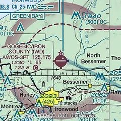
|
| Airport distance calculator |
|---|
|
|
| Sunrise and sunset |
|---|
|
Times for 18-Feb-2026
| | Local
(UTC-6) | | Zulu
(UTC) |
|---|
| Morning civil twilight | | 06:29 | | 12:29 |
| Sunrise | | 07:00 | | 13:00 |
| Sunset | | 17:29 | | 23:29 |
| Evening civil twilight | | 18:00 | | 24:00 |
|
| Current date and time |
|---|
| Zulu (UTC) | 18-Feb-2026 07:55:44 |
|---|
| Local (UTC-6) | 18-Feb-2026 01:55:44 |
|---|
|
| METAR |
|---|
| KIWD | 180714Z AUTO 10023G29KT 9SM -SN BKN010 OVC014 M01/M02 A2956 RMK AO2 PK WND 10029/0713 CIG 007V013 PRESFR P0000 FZRANO
|
|
| TAF |
|---|
| KIWD | 180520Z 1806/1906 12019G23KT P6SM -RASN SCT020 BKN025 OVC080 WS020/11050KT FM180800 10019G32KT 3SM FZRA SHSN OVC020 WS020/12055KT TEMPO 1808/1812 2SM -SHSN OVC015 FM181200 11018G30KT 2SM -SHSNPL OVC012 WS020/12055KT PROB30 1814/1816 3/4SM -SHSN OVC001 FM181600 11014G23KT 4SM BR BKN009 PROB30 1816/1818 2SM -SHRASN OVC004 FM190000 12007KT 4SM -SHSN BKN011
|
|
| NOTAMs |
|---|
NOTAMs are issued by the DoD/FAA and will open in a separate window not controlled by AirNav.
|
|

