FAA INFORMATION EFFECTIVE 14 MAY 2026
Location
| FAA Identifier: | JBR |
| Lat/Long: | 35-49-54.1600N 090-38-47.1190W
35-49.902667N 090-38.785317W
35.8317111,-90.6464219
(estimated) |
| Elevation: | 262.1 ft. / 79.9 m (surveyed) |
| Variation: | 00W (2015) |
| From city: | 3 miles E of JONESBORO, AR |
| Time zone: | UTC -5 (UTC -6 during Standard Time) |
| Zip code: | 72401 |
Airport Operations
| Airport use: | Open to the public |
| Activation date: | 04/1940 |
| Control tower: | no |
| ARTCC: | MEMPHIS CENTER |
| FSS: | JONESBORO FLIGHT SERVICE STATION |
| NOTAMs facility: | JBR (NOTAM-D service available) |
| Attendance: | 0600-2100
FOR SVC AFT HRS, CALL 870-935-1770. |
| Wind indicator: | lighted |
| Segmented circle: | yes |
| Lights: | ACTVT ODALS RWY 23; VASI RWY 23; MIRL RWY 05/23 & RWY 13/31; TWY LGTS - CTAF. |
| Beacon: | white-green (lighted land airport)
Operates sunset to sunrise. |
Airport Communications
| CTAF/UNICOM: | 123.0 |
| WX ASOS: | 118.525 (870-932-4010) |
- APCH/DEP SVC PRVDD BY MEMPHIS ARTCC ON FREQS 120.075/289.4 (WALNUT RIDGE RCAG).
Nearby radio navigation aids
| VOR radial/distance | | VOR name | | Freq | | Var |
|---|
| JBRr227/3.8 | | JONESBORO VOR/DME | | 115.85 | | 00W |
| ARGr134/22.4 | | WALNUT RIDGE VORTAC | | 114.50 | | 04E |
| GQEr340/30.2 | | GILMORE VOR/DME | | 113.00 | | 04E |
Airport Services
| Fuel available: | 100LL JET-A |
| Parking: | hangars and tiedowns |
| Airframe service: | MAJOR |
| Powerplant service: | MAJOR |
| Bottled oxygen: | NONE |
| Bulk oxygen: | NONE |
Runway Information
Runway 5/23
| Dimensions: | 6200 x 150 ft. / 1890 x 46 m |
| Surface: | asphalt/grooved, in good condition |
| Weight bearing capacity: | | Single wheel: | 100.0 | | Double wheel: | 160.0 | | Double tandem: | 200.0 |
|
| Runway edge lights: | medium intensity |
| RUNWAY 5 | | RUNWAY 23 |
| Latitude: | 35-49.728572N | | 35-50.382358N |
| Longitude: | 090-39.074418W | | 090-38.109982W |
| Elevation: | 256.0 ft. | | 258.5 ft. |
| Traffic pattern: | left | | left |
| Runway heading: | 050 magnetic, 050 true | | 230 magnetic, 230 true |
| Markings: | nonprecision, in good condition | | precision, in good condition |
| Visual slope indicator: | | | 4-box VASI on left (3.00 degrees glide path) |
| Approach lights: | | | ODALS: omnidirectional approach lighting system |
| Runway end identifier lights: | no | | no |
| Touchdown point: | yes, no lights | | yes, no lights |
| Instrument approach: | | | ILS |
Runway 13/31
| Dimensions: | 4099 x 150 ft. / 1249 x 46 m |
| Surface: | asphalt/grooved, in good condition |
| Weight bearing capacity: | | Single wheel: | 50.0 | | Double wheel: | 60.0 | | Double tandem: | 95.0 |
|
| Runway edge lights: | medium intensity |
| RUNWAY 13 | | RUNWAY 31 |
| Latitude: | 35-49.908783N | | 35-49.434252N |
| Longitude: | 090-39.372600W | | 090-38.782115W |
| Elevation: | 262.1 ft. | | 251.5 ft. |
| Traffic pattern: | left | | left |
| Runway heading: | 135 magnetic, 135 true | | 315 magnetic, 315 true |
| Markings: | nonprecision, in fair condition | | nonprecision, in fair condition |
| Runway end identifier lights: | | | no |
| Touchdown point: | yes, no lights | | yes, no lights |
| Obstructions: | 18 ft. road, 490 ft. from runway, 16:1 slope to clear | | 35 ft. tree, 1500 ft. from runway, 180 ft. right of centerline, 37:1 slope to clear |
Airport Ownership and Management from official FAA records
| Ownership: | Publicly-owned |
| Owner: | CITY OF JONESBORO
PO BOX 1845
JONESBORO, AR 72403
Phone 870-932-1052 |
| Manager: | GEORGE JACKSON
P.O. BOX 1293
JONESBORO, AR 72403
Phone 870-761-4149 |
Additional Remarks
| A39-05/23 | PCR VALUE: 420/F/C/X/T |
| - | FOR CD CTC MEMPHIS ARTCC AT 901-368-8453/8449. |
Instrument Procedures
NOTE: All procedures below are presented as PDF files. If you need a reader for these files, you should download the free Adobe Reader.NOT FOR NAVIGATION. Please procure official charts for flight.
FAA instrument procedures published for use from 14 May 2026 at 0901Z to 11 June 2026 at 0900Z.
IAPs - Instrument Approach Procedures |
|---|
| ILS OR LOC RWY 23 | |
download (326KB) |
| RNAV (GPS) RWY 05 | |
download (249KB) |
| RNAV (GPS) RWY 23 | |
download (284KB) |
| RNAV (GPS) RWY 31 | |
download (207KB) |
| NOTE: Special Alternate Minimums apply | |
download (145KB) |
| NOTE: Special Take-Off Minimums/Departure Procedures apply | |
download (131KB) |
Other nearby airports with instrument procedures:
KPGR - Kirk Field Airport (15 nm NE)
KARG - Walnut Ridge Regional Airport (22 nm NW)
KMXA - Manila Municipal Airport (24 nm E)
M19 - Newport Regional Airport (28 nm SW)
M70 - Pocahontas Municipal Airport (29 nm NW)
|
|

Road maps at:
MapQuest
Bing
Google
| Aerial photo |
|---|
WARNING: Photo may not be current or correct
 Photo courtesy of the Arkansas Department of Aeronautics
Taken in the Spring of 2007
Photo courtesy of the Arkansas Department of Aeronautics
Taken in the Spring of 2007
Do you have a better or more recent aerial photo of Jonesboro Municipal Airport that you would like to share? If so, please send us your photo.
|
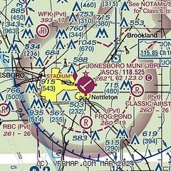
| Sectional chart |
|---|
|
CAUTION: Diagram may not be current

| Airport distance calculator |
|---|
|
|
| Sunrise and sunset |
|---|
|
Times for 03-Jun-2026
| | Local
(UTC-5) | | Zulu
(UTC) |
|---|
| Morning civil twilight | | 05:18 | | 10:18 |
| Sunrise | | 05:48 | | 10:48 |
| Sunset | | 20:13 | | 01:13 |
| Evening civil twilight | | 20:43 | | 01:43 |
|
| Current date and time |
|---|
| Zulu (UTC) | 03-Jun-2026 12:59:13 |
|---|
| Local (UTC-5) | 03-Jun-2026 07:59:13 |
|---|
|
| TAF |
|---|
| KJBR | 031120Z 0312/0412 04005KT P6SM BKN250 FM031600 09008KT P6SM FEW050 SCT250 FM040100 12003KT P6SM SKC AMD NOT SKED
|
|
| NOTAMs |
|---|
NOTAMs are issued by the DoD/FAA and will open in a separate window not controlled by AirNav.
|
|


