FAA INFORMATION EFFECTIVE 22 JANUARY 2026
Location
| FAA Identifier: | ARG |
| Lat/Long: | 36-07-28.8000N 090-55-30.4000W
36-07.480000N 090-55.506667W
36.1246667,-90.9251111
(estimated) |
| Elevation: | 279 ft. / 85.0 m (surveyed) |
| Variation: | 01E (2000) |
| From city: | 4 miles NE of WALNUT RIDGE, AR |
| Time zone: | UTC -6 (UTC -5 during Daylight Saving Time) |
| Zip code: | 72476 |
Airport Operations
| Airport use: | Open to the public |
| Activation date: | 10/1943 |
| Control tower: | no |
| ARTCC: | MEMPHIS CENTER |
| FSS: | JONESBORO FLIGHT SERVICE STATION |
| NOTAMs facility: | ARG (NOTAM-D service available) |
| Attendance: | MON-SUN 0800-1700
IF ARPT ATTENDANT NOT AVBL, CALL 870-886-5432. FEE CHRG UNLESS PRIOR ARRANGEMENTS MADE. |
| Wind indicator: | lighted |
| Segmented circle: | yes |
| Lights: | ACTVT MALSF RWY 04; ODALS RWY 18; REIL RWY 18; MIRL RWY 04/22, RWY 18/36 - CTAF. |
| Beacon: | white-green (lighted land airport)
Operates sunset to sunrise. |
Airport Communications
| CTAF/UNICOM: | 122.8 |
| WX AWOS-3PT: | 126.525 (870-886-2537) |
- APCH/DEP SVC PRVDD BY MEMPHIS ARTCC ON FREQS 120.075/289.4 (WALNUT RIDGE RCAG).
Nearby radio navigation aids
| VOR radial/distance | | VOR name | | Freq | | Var |
|---|
| ARGr054/1.6 | | WALNUT RIDGE VORTAC | | 114.50 | | 04E |
| JBRr313/22.2 | | JONESBORO VOR/DME | | 115.85 | | 00W |
Airport Services
| Fuel available: | 100LL JET-A
A:JET A SELF SVC FUEL AVBL 24 HRS WITH CC/FULL SVC AVBL 0800-1700.
100LL:SELF SVC FUEL AVBL 24 HRS WITH CC/FULL SVC AVBL 0800-1700. |
| Parking: | hangars and tiedowns |
| Airframe service: | MAJOR |
| Powerplant service: | MAJOR |
| Bottled oxygen: | NONE |
| Bulk oxygen: | NONE |
Runway Information
Runway 4/22
| Dimensions: | 6001 x 150 ft. / 1829 x 46 m |
| Surface: | asphalt, in good condition |
| Weight bearing capacity: | | Single wheel: | 40.0 | | Double wheel: | 60.0 | | Double tandem: | 110.0 |
|
| Runway edge lights: | medium intensity |
| RUNWAY 4 | | RUNWAY 22 |
| Latitude: | 36-06.813822N | | 36-07.512575N |
| Longitude: | 090-56.019792W | | 090-55.157108W |
| Elevation: | 279.1 ft. | | 272.9 ft. |
| Traffic pattern: | left | | left |
| Runway heading: | 044 magnetic, 045 true | | 224 magnetic, 225 true |
| Markings: | nonprecision, in good condition | | nonprecision, in good condition |
| Visual slope indicator: | | | 4-light PAPI on left (3.00 degrees glide path) |
| Approach lights: | MALSF: 1,400 foot medium intensity approach lighting system with sequenced flashers | | |
| Touchdown point: | yes, no lights | | yes, no lights |
Runway 13/31
| Dimensions: | 5003 x 150 ft. / 1525 x 46 m |
| Surface: | concrete, in fair condition |
| Weight bearing capacity: | | Single wheel: | 40.0 | | Double wheel: | 60.0 | | Double tandem: | 110.0 |
|
| RUNWAY 13 | | RUNWAY 31 |
| Latitude: | 36-08.078557N | | 36-07.495207N |
| Longitude: | 090-55.875382W | | 090-55.157023W |
| Elevation: | 272.2 ft. | | 272.8 ft. |
| Traffic pattern: | left | | left |
| Runway heading: | 134 magnetic, 135 true | | 314 magnetic, 315 true |
| Markings: | basic, in good condition | | basic, in good condition |
| Touchdown point: | yes, no lights | | yes, no lights |
| Obstructions: | 15 ft. road, 600 ft. from runway, 26:1 slope to clear | | 1 ft. berm, 220 ft. from runway, 20:1 slope to clear |
Runway 18/36
| Dimensions: | 5001 x 150 ft. / 1524 x 46 m |
| Surface: | concrete, in fair condition |
| Weight bearing capacity: | | Single wheel: | 40.0 | | Double wheel: | 60.0 | | Double tandem: | 110.0 |
|
| Runway edge lights: | medium intensity |
| RUNWAY 18 | | RUNWAY 36 |
| Latitude: | 36-07.964087N | | 36-07.139857N |
| Longitude: | 090-55.396178W | | 090-55.396835W |
| Elevation: | 273.3 ft. | | 272.2 ft. |
| Traffic pattern: | left | | left |
| Runway heading: | 179 magnetic, 180 true | | 359 magnetic, 000 true |
| Markings: | precision, in good condition | | precision, in good condition |
| Approach lights: | ODALS: omnidirectional approach lighting system | | |
| Runway end identifier lights: | yes | | |
| Touchdown point: | yes, no lights | | yes, no lights |
| Instrument approach: | LOCALIZER | | |
| Obstructions: | 15 ft. road, 1000 ft. from runway | | none |
Airport Ownership and Management from official FAA records
| Ownership: | Publicly-owned |
| Owner: | CITY OF WALNUT RIDGE
300 WEST MAIN STREET
WALNUT RIDGE, AR 72476
Phone 870-886-6638 |
| Manager: | STACY HOGGARD
11 SKY WATCH
WALNUT RIDGE, AR 72476
Phone 870-886-5432 |
Additional Remarks
| - | GOVERNMENT CONTRACT FUEL AVBL. |
| - | AGRICULTURAL OPS ON AND INVOF ARPT APR THRU SEP. |
| - | MIGRATORY BIRDS INVOF ARPT OCT THRU JAN. |
| - | FOR CD CTC MEMPHIS ARTCC AT 901-368-8453/8449. |
Instrument Procedures
NOTE: All procedures below are presented as PDF files. If you need a reader for these files, you should download the free Adobe Reader.NOT FOR NAVIGATION. Please procure official charts for flight.
FAA instrument procedures published for use from 22 January 2026 at 0901Z to 19 February 2026 at 0900z.
IAPs - Instrument Approach Procedures |
|---|
| RNAV (GPS) RWY 04 | |
download (212KB) |
| RNAV (GPS) RWY 18 | |
download (241KB) |
| RNAV (GPS) RWY 22 | |
download (221KB) |
| RNAV (GPS) RWY 36 | |
download (238KB) |
| LOC RWY 18 | |
download (186KB) |
| NOTE: Special Alternate Minimums apply | |
download (121KB) |
| NOTE: Special Take-Off Minimums/Departure Procedures apply | |
download (131KB) |
Other nearby airports with instrument procedures:
M70 - Pocahontas Municipal Airport (7 nm N)
KPGR - Kirk Field Airport (20 nm E)
4M9 - Corning Municipal Airport (21 nm NE)
KJBR - Jonesboro Municipal Airport (22 nm SE)
M19 - Newport Regional Airport (32 nm SW)
|
|

Road maps at:
MapQuest
Bing
Google
| Aerial photo |
|---|
WARNING: Photo may not be current or correct
 Photo courtesy of AirNav, LLC
Photo taken 11-Sep-2012
looking north.
Photo courtesy of AirNav, LLC
Photo taken 11-Sep-2012
looking north.
Do you have a better or more recent aerial photo of Walnut Ridge Regional Airport that you would like to share? If so, please send us your photo.
|
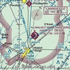
| Sectional chart |
|---|
|
| Airport distance calculator |
|---|
|
|
| Sunrise and sunset |
|---|
|
Times for 23-Jan-2026
| | Local
(UTC-6) | | Zulu
(UTC) |
|---|
| Morning civil twilight | | 06:44 | | 12:44 |
| Sunrise | | 07:12 | | 13:12 |
| Sunset | | 17:20 | | 23:20 |
| Evening civil twilight | | 17:47 | | 23:47 |
|
| Current date and time |
|---|
| Zulu (UTC) | 24-Jan-2026 02:03:27 |
|---|
| Local (UTC-6) | 23-Jan-2026 20:03:27 |
|---|
|
| METAR |
|---|
| KARG | 240156Z AUTO 04017KT 10SM OVC075 M07/M20 A3056 RMK AO2 SLP354 T10721200 FZRANO $
|
|
| TAF |
|---|
KJBR
22nm SE | 231727Z 2318/2418 03020G29KT P6SM BKN050 BKN150 FM240000 04017G24KT P6SM OVC050 FM240800 04015G25KT 4SM PLSN BKN020 OVC040 FM241500 04014G23KT 2SM PLSN OVC015
|
|
| NOTAMs |
|---|
NOTAMs are issued by the DoD/FAA and will open in a separate window not controlled by AirNav.
|
|


