FAA INFORMATION EFFECTIVE 19 FEBRUARY 2026
Location
| FAA Identifier: | 4M9 |
| Lat/Long: | 36-24-15.2330N 090-38-52.5350W
36-24.253883N 090-38.875583W
36.4042314,-90.6479264
(estimated) |
| Elevation: | 293.2 ft. / 89.4 m (surveyed) |
| Variation: | 01E (1995) |
| From city: | 3 miles W of CORNING, AR |
| Time zone: | UTC -6 (UTC -5 during Daylight Saving Time) |
| Zip code: | 72422 |
Airport Operations
| Airport use: | Open to the public |
| Activation date: | 12/1970 |
| Control tower: | no |
| ARTCC: | MEMPHIS CENTER |
| FSS: | JONESBORO FLIGHT SERVICE STATION |
| NOTAMs facility: | JBR (NOTAM-D service available) |
| Attendance: | MON-FRI 0700-1900, ALL SAT 0800-1200, ALL SUN UNATTNDD |
| Wind indicator: | lighted |
| Segmented circle: | no |
| Lights: | ACTVT REIL RWY 18 & 36; PAPI RWY 18 & 36; MIRL RWY 18/36; AND TWY LGTS - CTAF. |
| Beacon: | white-green (lighted land airport)
Operates sunset to sunrise. |
Airport Communications
| CTAF/UNICOM: | 123.0 |
| WX AWOS-3T: | 118.325 (870-857-9702) |
- APCH/DEP SVC PRVDD BY MEMPHIS ARTCC ON FREQS 120.075/289.4 (WALNUT RIDGE RCAG).
Nearby radio navigation aids
| VOR radial/distance | | VOR name | | Freq | | Var |
|---|
| ARGr036/23.0 | | WALNUT RIDGE VORTAC | | 114.50 | | 04E |
| JBRr355/31.9 | | JONESBORO VOR/DME | | 115.85 | | 00W |
Airport Services
| Fuel available: | 100LL JET-A
100LL:SELF SVC 100LL & JET A AVBL 24 HRS WITH CREDIT CARD. |
| Parking: | tiedowns |
| Airframe service: | MAJOR |
| Powerplant service: | MAJOR |
| Bulk oxygen: | NONE |
Runway Information
Runway 18/36
| Dimensions: | 4299 x 60 ft. / 1310 x 18 m |
| Surface: | asphalt, in good condition |
| Weight bearing capacity: | |
| Runway edge lights: | medium intensity |
| RUNWAY 18 | | RUNWAY 36 |
| Latitude: | 36-24.608100N | | 36-23.899683N |
| Longitude: | 090-38.871367W | | 090-38.879800W |
| Elevation: | 292.4 ft. | | 291.8 ft. |
| Traffic pattern: | left | | left |
| Runway heading: | 180 magnetic, 181 true | | 000 magnetic, 001 true |
| Markings: | nonprecision, in good condition | | nonprecision, in good condition |
| Visual slope indicator: | 2-light PAPI on left (3.00 degrees glide path) | | 2-light PAPI on left (3.00 degrees glide path) |
| Runway end identifier lights: | yes | | yes |
| Touchdown point: | yes, no lights | | yes, no lights |
| Obstructions: | 20 ft. pole, 675 ft. from runway, 200 ft. left of centerline, 23:1 slope to clear | | 11 ft. road, 510 ft. from runway, 28:1 slope to clear |
Airport Ownership and Management from official FAA records
| Ownership: | Publicly-owned |
| Owner: | CITY OF CORNING
308 WEST MAIN
CORNING, AR 72422
Phone 870-857-6716 |
| Manager: | MATT WOOLARD
P.O. BOX 451
CORNING, AR 72422
Phone 870-323-0304 |
Additional Remarks
| - | FOR CD CTC MEMPHIS ARTCC AT 901-368-8453/8449. |
Instrument Procedures
NOTE: All procedures below are presented as PDF files. If you need a reader for these files, you should download the free Adobe Reader.NOT FOR NAVIGATION. Please procure official charts for flight.
FAA instrument procedures published for use from 19 February 2026 at 0901Z to 19 March 2026 at 0900Z.
IAPs - Instrument Approach Procedures |
|---|
| RNAV (GPS) RWY 18 | |
download (178KB) |
| RNAV (GPS) RWY 36 | |
download (178KB) |
| NOTE: Special Alternate Minimums apply | |
download (121KB) |
| NOTE: Special Take-Off Minimums/Departure Procedures apply | |
download (131KB) |
Other nearby airports with instrument procedures:
M70 - Pocahontas Municipal Airport (18 nm SW)
KARG - Walnut Ridge Regional Airport (21 nm SW)
KPGR - Kirk Field Airport (22 nm S)
KPOF - Poplar Bluff Regional Business Airport (27 nm NE)
KTKX - Kennett Memorial Airport (31 nm E)
|
|

Road maps at:
MapQuest
Bing
Google
| Aerial photo |
|---|
WARNING: Photo may not be current or correct
 Photo courtesy of the Arkansas Department of Aeronautics
Taken in the Spring of 2007
Photo courtesy of the Arkansas Department of Aeronautics
Taken in the Spring of 2007
Do you have a better or more recent aerial photo of Corning Municipal Airport that you would like to share? If so, please send us your photo.
|
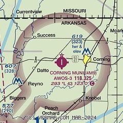
| Sectional chart |
|---|
|
| Airport distance calculator |
|---|
|
|
| Sunrise and sunset |
|---|
|
Times for 21-Feb-2026
| | Local
(UTC-6) | | Zulu
(UTC) |
|---|
| Morning civil twilight | | 06:18 | | 12:18 |
| Sunrise | | 06:44 | | 12:44 |
| Sunset | | 17:48 | | 23:48 |
| Evening civil twilight | | 18:14 | | 00:14 |
|
| Current date and time |
|---|
| Zulu (UTC) | 21-Feb-2026 06:30:27 |
|---|
| Local (UTC-6) | 21-Feb-2026 00:30:27 |
|---|
|
| METAR |
|---|
| K4M9 | 210615Z AUTO 16005KT 2 1/2SM BR FEW032 SCT042 OVC060 07/07 A3006 RMK A01
|
|
| TAF |
|---|
KJBR
34nm S | 210520Z 2106/2206 02006KT P6SM OVC060 PROB30 2106/2109 -SHRA FM211200 03010KT P6SM OVC060 FM211800 02012KT P6SM OVC045 FM212200 36008KT P6SM BKN050 FM220100 33008KT P6SM SCT050
|
|
| NOTAMs |
|---|
NOTAMs are issued by the DoD/FAA and will open in a separate window not controlled by AirNav.
|
|

